Policy S/RSC/BRC: Babraham Research Campus
1. A site wide Masterplan will be prepared by the landowners and/or promoters in conjunction with the Council and in consultation with the local community and other stakeholders. The Masterplan should be broadly aligned with the indicative Spatial Framework shown at Figure 75 and will need to identify the broad distribution of land uses, infrastructure delivery and phasing and will be used as a basis for the consideration of subsequent planning applications. The Masterplan should be agreed by the Council prior to the approval of any planning applications (and may be subsequently updated by the landowners and/or promoters and agreed by the Local Planning Authorities).
2. Given the scale and long term construction of the development, a site wide Design Code must be submitted alongside the Masterplan. This will set the overarching design and placemaking objectives and principles, ensuring that each phase of future development positively contributes towards the high quality outcomes expected.
Objectives and place identity
3. Babraham Research Campus will continue to be a world leading bioscience research and innovation campus, co-locating start up, growing and established bioscience companies. Located at the heart of the Cambridge Southern Cluster life-science ecosystem, the campus will continue to play a key role in bringing together academia and commercial bioscience. It will continue to develop into a place where people can live and work, set within an extensive network of green and blue infrastructure which supports both biodiversity and the health and wellbeing of employees and the wider community.
Uses
4. Babraham Research Campus, including land removed from the Green Belt, is allocated for mixed use development comprising:
a. Within the employment-led development area, approximately 48,000 square metres gross internal area (GIA) additional research and development (Class (E(g)(ii)) floorspace; and
b. Within the residential-led development area:
i. Approximately 83 additional Campus worker and affordable homes to support the needs of the Campus; and
ii. Appropriate supporting ancillary uses and infrastructure, including up to approximately 850 square metres gross internal area of nursery space (class (E(f)), and 500 square metres of flexible amenity space (Class F2 (a), (b), and Class E (a), (b), (d)).
5. Development will be required to meet the National Planning Policy Framework Golden Rules for land released from Green Belt, including providing 50% affordable housing on residential schemes.
a. Delivery of uses in the Strategic Enhancement Area (SEA), including:
i. Compensating for the loss of Green Belt by enhancing the land in the SEA with green infrastructure and accessible open and green space;
ii. Mitigate any adverse impacts of new development on the setting of the Cambridge Green Belt and wider landscape;
iii. Sustainable drainage systems (SuDS) such as swales, wetlands and reed beds; and
iv. Creating new habitats for wildlife and, habitat compensation through the provision of same or better quality habitat conditions.
The development of Babraham Research Campus must do the following:
Context
6. Through the preparation of a Landscape Visual Impact Assessment and more detailed Heritage Impact Assessment, inform specific mitigations and protect, and where appropriate, enhance the significance of heritage assets and their setting, including the Grade I Listed St Peter’s Church, Grade II* Listed Babraham Hall and nearby off-site heritage assets.
7. Protect the legibility, appearance, and rural character of the Babraham Conservation area and the Lodge building which should be retained, a non-designated heritage asset.
8. Limit development of new buildings to areas of existing development, undeveloped areas of land in the far north of the site, and The Close residential area. Gardens surrounding the Grade I Church and Grade II Babraham Hall must be excluded from development.
9. Retain, preserve and enhance key short and long-range views from, into and within the site, including facing west and east from Babraham Hall along The Avenue, and internal views of heritage assets and the formal gardens / open spaces to the south of the River Granta, by:
a. Ensuring development sits below the existing tree-line;
b. Incorporating landscape and tree buffers, including forest scale trees and under storey planting where appropriate;
c. Responding sensitively to the setting of heritage assets within the site when redeveloping existing buildings; and
d. Preparing a Views Analysis to inform specific mitigations.
10. Retain and, where possible, supplement the existing tree coverage and landscape buffers, across the site, including forest scale trees and under storey planting where appropriate, to limit the visual impact of development on heritage assets, views and landscape setting.
11. In accordance with the indicative Spatial Framework for the site, require a wide landscape buffer (minimum 20 metres) in/adjacent to any development in the north-west of site in order to satisfactorily mitigate any adverse impacts of new development on the setting of the Cambridge Green Belt and wider landscape character including views to the north from Gog Magog Hills and Roman Road, whilst creating an attractive gateway into the campus from the north.
12. Apply the sequential approach to flood risk within the site, ensuring any development is subject to appropriate mitigation and does not increase flood risk elsewhere.
13. Only water compatible development should be located within Flood Zone 3 and a site specific FRA will need to further assess the potential for groundwater flooding to inform the need for appropriate mitigation measures. The SEA is an appropriate location for flood risk mitigation.
14. Given the known significant potential for archaeological remains in this area, development proposals must be accompanied by an appropriate archaeological assessment, which includes information on the significance of the heritage asset, including the extent, character and condition of the archaeological resource and the likely impact of the development on the archaeological remains.
Built form
15. Ensure the built area of the campus is contained within the site allocation boundary shown on the policies map and the indicative Spatial Framework Diagram. Context
16. Be comprehensively planned and delivered to ensure development proposals are fully integrated with the wider Campus and to preserve and enhance the setting of identified heritage assets. This must involve:
a. Preparing a site-wide Masterplan, which must be submitted for approval by the Local Planning Authority as part of the first application for planning permission; and
b. Preparing a site-wide Design Codes for each phase of the development to ensure a high quality of development, which must be submitted and approved before the first reserved matters planning application is determined.
Nature
17. Maintain and enhance the wider landscape within the Campus, including the corridor of the River Granta.
18. Deliver compensatory improvements to the environmental quality and accessibility of remaining Green Belt land in the Strategic Enhancement Area (S/SEA/BRC), in line with a Green Belt Enhancement Strategy for the area prepared by the applicant. This should:
a. Include measures such as walking loops, new wetlands, restoration of ponds, and other associated green infrastructure projects;
b. Incorporate the enhancement of existing hedgerows and woodland that form the boundaries of the site, particularly to the east and west; and
c. Ensure measures integrate with the green and blue infrastructure network across the site and in the wider area.
Movement
19. Ensure proposals improve movement within the Campus and deliver connections to high-quality sustainable transport, by:
a. Securing improvements to pedestrian and cycle and equestrian routes connecting to nearby villages, railway stations and the proposed Cambridge South East Transport (CSET) travel hub;
b. Supporting the provision of high-quality access to existing forms of public transport, including routes to nearby bus-stops and the provision of an on-site Mobility Hub; and
c. Contributing to and securing high quality local public transport routes to nearby railway stations, employment campuses and Cambridge City Centre, including via the Cambridge South East Transport schemes (CSET).
20. Where required, contribute financially to strategic public transport and active travel schemes and highways mitigation in the south-east corridor, appropriate to the scale and nature of the development.
21. A trip budget based on detailed evidence must be agreed with the Local Highways Authority prior to submission of the outline application, together with a strategic and local transport mitigation plan. A monitor and manage approach will be taken to ensure that the development remains within the agreed trip budget for the site throughout its delivery.
22. To support delivery of the agreed campus-wide masterplan, a strategic and local transport mitigation plan must be prepared by the developer in consultation with the Local Highways Authority and Local Planning Authority.
The employment-led development must, additionally, do the following:
Uses
23. Support research and development (Class E(g)ii)) floorspace and supporting uses. Future development proposals will need to deliver spaces for start-ups and the Babraham Institute, and these units should be located close to the centre of the site.
Built form
24. Be limited to the employment-led development area identified in the indicative Spatial Framework.
25. Encourage opportunities for collaboration between future occupants, including delivering communal facilities on the ground floors, including communal space within the centre of the Campus designed for meeting, socialising and holding events
26. Be of high quality and innovative design which reflects the cutting-edge science which takes place within them whilst enhancing the heritage assets, preserving the rural character and sense of openness of the sites’ context.
27. Deliver active ground floor uses and frontages wherever possible.
28. Respond positively to the site’s immediate context, in particular heritage assets Grade I Listed St Peter’s Church, Grade II Listed Babraham Hall, and their setting, wider landscape character and identified key views, through the selection of massing, material palettes and overall design of new research and development buildings.
Public space
29. Include enhanced meeting places as part of the public realm and open spaces.
The residential-led development must, additionally, do the following:
Uses
30. Be limited to addressing the needs for campus worker housing, with the mix of typologies and tenures (including affordable housing) informed by an accommodation needs assessment for the campus, the Greater Cambridge Housing Strategy, and discussions with the Local Planning Authority.
31. Provide ancillary uses to meet the daily needs of residents, including a new, expanded Nursery and a new amenity building capable of accommodating flexible space to address Campus and local needs, e.g. small shop and gym , which must be open to the wider public and not undermine the viability of existing services in the village.
Built form
32. Be located in the residential-led development area identified in the indicative Spatial Framework.
33. Deliver active ground floor uses wherever possible.
34. Take a comprehensive, landscape-led approach to the design through the preparation of a Masterplan, which must be prepared by the applicant and submitted as part of the planning application for this part of the site. This must ensure development:
a. Maintains the low-density character of the site;
b. Secures building design which is sympathetic to the sensitive village-edge location; and
c. Focuses development as near to the Babraham High Street as possible.
Lifespan
35. In addition to the requirements on the validation checklist, the following will be required at the submission of an outline or major planning application:
a. Phasing and delivery plan, including indicative costings and potential delivery through Section 106 agreements or CIL;
b. A Parking strategy;
c. An Integrated water management plan;
d. A Waste management plan;
e. A Site Specific Flood Risk Assessment; and
f. A strategic and local transport mitigation plan (in consultation with the Local Highways Authority and Local Planning Authority).
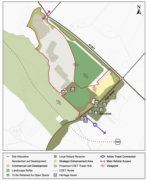
Figure 75: Indicative Spatial Framework for Policy S/RSC/BRC: Babraham Research Campus
Supporting information
3.4.19. Babraham Research Campus focuses on early-stage bioscience enterprise. Over 60 companies, 2,000 employees and 300 academic researchers are currently located on the site, which sits within the parkland setting of Babraham Hall. This policy will guide future development at the Campus to support the continued success of this nationally important facility.
3.4.20. The Local Plan proposes to remove the existing built areas and an area for new development from the Green Belt shown at Figure 76 to support the future needs of the Campus.
3.4.21. The policy and indicative Spatial Framework identify three areas within the Campus, each with specific policy requirements:
- An employment-led development area that will deliver additional research
- and development floorspace and ancillary uses;
- A residential-led development area, which would enable the redevelopment of The Close for additional residential units, retail floorspace, additional nursery floorspace, and land for amenity uses; and
- A Strategic Enhancement Area (S/SEA/BRC), located to the south of the River Granta, which is not proposed for development but for green infrastructure and ecological enhancements. The Strategic Enhancement Area also aims to ensure sufficient separation between neighbouring settlements and maintains a soft, green landscape to protect a development’s rural setting. These areas may also be used to deliver other associated uses, including drainage, habitat compensation and informal open space.
Overarching requirements
3.4.22. By removing the site from the Green Belt and setting clear requirements about the scale and type of development, this policy will co-ordinate future development proposals to ensure they deliver high-quality buildings and significant benefits for the local and national economy. Requiring all future development proposals to protect and enhance heritage assets will ensure their historical significance will be preserved for future generations. Allocating development in suitable areas of the Campus, maintaining key views and retaining and enhancing the existing tree coverage will mean that heritage assets and their setting are protected. Additionally, careful consideration of building heights, form and massing will mean that new development sensitively relates to its rich surroundings.
3.4.23. The policy stipulates that development proposals should maintain and enhance the wider landscape, including the River Granta, and provide substantial compensatory improvements to the environmental quality and accessibility to the Strategic Enhancement Area. These measures are important because they will support South Cambridgeshire District Council’s aim to improve biodiversity in the region. The Cambridge Green Belt Study (2021) identifies that the Campus makes a relatively limited contribution to Green Belt purposes, and the harm of its release would be low. The study highlighted that harm could be ameliorated by the enhancement of existing hedgerows and woodland that forms the boundaries of the site, particularly to the east and west. This would also help ensure that development enhances existing landscape features, including parkland features, and is in keeping with the wider wooded character of the Campus.
3.4.24. Support for continued growth of nationally important research campus meeting evidenced needs for additional space, provides justification for the exceptional circumstances required to release this land from the Green Belt, including providing policy support for key worker housing in this location. As a residential development on land formerly in the Green Belt this would be subject to national planning policy’s ‘golden rules’, which would include 50% affordable housing.
3.4.25. The area adjoining the River Granta falls within flood zones. Masterplanning will need to respond to the appropriately, responding to requirements set out in the Local Plan.
3.4.26. By ensuring all development proposals improve movement within the Campus, the policy will help to improve the experience of people who currently use the Campus. Improving routes that connect the Campus with sustainable forms of public transportation, will mean that the policy helps to support the need to reduce carbon emissions in the local and wider area. Similarly, through providing contributions to public transportation schemes, future development will provide monetary contributions to deliver this wider aim. In addition to the above, the Greater Cambridge Infrastructure Delivery Plan (IDP) (2026) has identified that the site, will require: a financial contribution towards 24.7 square metres at existing local GP practices, the provision of 15 square metres community space, 14 square metres library space to be delivered as a community library, and a range of outdoor sports pitches to support the delivery of the site during the plan period and beyond. The exact quantum and phasing of infrastructure will need to be kept under review as the development comes forward, including phases beyond the plan period. This should be informed by on-going engagement with statutory bodies and undertakers.
Employment led development
3.4.27. Delivering research and development floorspace and supporting uses on this site will help a world-leading research campus to expand upon its current success. The policy requires world class facilities, including communal spaces, to foster collaboration and the sharing of ideas between employees. Similarly, delivering active ground floor uses will support the aim of making the Campus a vibrant area for people to work and visit.
3.4.28. Through carefully designing any future development, especially in relation to sensitive massing and materials, new development will contribute positively to the character of the site and surrounding area, and avoid negative visual impacts upon Cambridge’s Green Belt, Babraham Conservation Area and neighbouring properties. Similarly, by managing the height of new buildings, the development will not have a domineering effect upon its surroundings and instead will complement the wider context.
Residential led development
3.4.29. Requiring a landscape-masterplan to guide the regeneration of The Close will mean that new residential units sensitively complement their surroundings and do not have a negative impact upon nearby heritage assets or the village. The policy requires future housing to be informed by an accommodation needs assessment, ensuring that the provision of affordable housing is supported by rigorous analysis. Delivering supporting uses to meet the daily needs of residents will mean that the site will help to improve the quality of life for residents, nearby villagers, and general users of the Campus. Similarly, requesting that proposals deliver active ground floor uses will mean that the new residential development has a sense of vitality.
3.4.30. The residential development area proposed in a sensitive location, close to the Babraham Conservation Area and forming part of the setting of listed buildings. Development will therefore need to be carefully designed to optimise the use of land whilst protecting and, where possible, enhancing these assets and their setting.
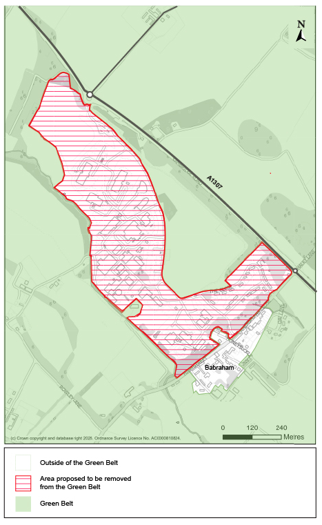
Figure 76: Map of Green Belt release to enable delivery of Babraham Research Campus
Tell us what you think
For further guidance on how to submit comments, please see the Representation Guidance Note.
All comments must be received by 25 September 2026 at 5pm.