Policy S/CE: Cambridge East
1. A new city district of approximately 8,000 homes delivered from 2032, subject to the necessary water infrastructure being available, significant employment floorspace in use classes E(g) and approximately 20,000 square metres gross internal area (GIA) of B2/B8 employment floorspace, with a range of supporting services and facilities, including retail, community, cultural, faith, leisure, education and sports and open space uses. The built area of the expansion will be contained within the Site Allocation boundary identified on the Policies Map.
2. A site-wide masterplan will be prepared by the landowners and/or promoters in conjunction with the Council and in consultation with the local community and other stakeholders. The masterplan should be broadly aligned with the indicative Spatial Framework shown at Figure 53 and will need to identify the broad distribution of land uses, infrastructure delivery and phasing. The masterplan will be used as a basis for the consideration of subsequent planning applications. A masterplan should be agreed by the Local Planning Authority prior to the approval of any planning applications (and may be subsequently updated by the landowners and/or promoters subject to agreement with the Local Planning Authority).
3. Given the scale and long-term construction of the development, a site-wide “Place Book” shall be prepared to establish the vision, place-making objectives and quality expectations for the new community and provide the foundation for a site-wide masterplan and design codes. Design codes will ensure that each phase of development positively contributes towards the high-quality placemaking outcomes expected.
Objectives and place identity
4. Cambridge East will be a vibrant, inclusive new city district that reflects the spirit of Cambridge while helping to shape its future. Rooted in a unique setting, Cambridge East will offer welcoming, walkable neighbourhoods which support an intergenerational community to live well, work purposefully, learn, and thrive.
5. A vibrant urban quarter will form the heart of this well-connected mixed-use district, bringing together cultural and commercial space, including research and development, to foster economic opportunity, collaboration and innovation. Green streets, public spaces and a new Cambridge Common will connect communities, promote wellbeing and support nature recovery. Excellent sustainable transport links will ensure seamless access to the City and beyond.
6. Guided by design excellence, environmental responsibility, and long-term stewardship, Cambridge East will set new standards for sustainable, high-quality placemaking.
Cambridge Airport
Uses
7. Cambridge East is allocated for mixed-use development, as shown on the Policies Map and indicative Spatial Framework, comprising:
a. Approximately 8,000 homes (to deliver 3,950 dwellings to 2045 subject to the necessary water infrastructure being available) of a range of sizes, types and tenures to meet the identified diverse housing needs and to support a mixed and balanced intergenerational community, specifically, including:
i. A total of 24 permanent Gypsy and Traveller pitches (within two sites of 12 pitches, each on approximately 1 hectare of land) located within but on the edge of the development, or outside but in close proximity to the site, meeting requirements of Policy H/GT; and
ii. 10% of the approximately 8,000 homes as specialist accommodation (within use classes C2 or C3), particularly for older people or those with disabilities.
b. Significant employment floorspace in use classes E(g), including offices and research and development as a key part of a new mixed use district centre and at other key locations where they are supported by good accessibility, recognising the site’s potential to provide a new key location for businesses within Greater Cambridge’s knowledge economy, as well as a minimum of 20,000 square metres (gross internal area) B2/B8 employment floorspace with good access to the road network to provide for mid-tech and general industrial uses;
c. Each phase must deliver a mix of uses to co-locate residential uses with amenities:
d. Provision of sports and leisure facilities, including as a minimum:
i. A 50 metre x 10 lane regional swimming pool preferably located opposite the Ice Rink;
ii. An indoor sports hall co-located with the swimming pool as part of a new leisure hub or regional indoor sports centre; and
iii. Outdoor pitches provision including a range of pitches including football, youth football, rugby, hockey and cricket pitches plus changing facilities;
e. Provision of a regional cultural hub that will complement and not compete with Cambridge city centre. This will include but not be limited to provision of a creative hub comprising a mix creative work, production and leisure spaces, and a community arts centre; and
f. A range of supporting services and facilities to meet the day-to-day needs of those living, working, visiting, travelling through and attending education there, including cultural, leisure, nursery, primary and secondary schools, health, community and library space, faith and retail uses. These uses will be delivered at a series of walkable and wheelable neighbourhood centres.
The development of Cambridge East must do the following:
Context
8. Establish a strong landscape-led framework to guide the structure of development and shape the relationship between the new city district, the existing urban edge and the wider landscape, supporting its identity and a well-considered transition between existing and proposed built form, settlement edges and the wider landscape. thrive.
9. Create a well-considered eastern approach to Cambridge that:
a. Is sensitive to local townscape, landscape, strategic views, dynamic views and heritage assets, including the rural setting of the village of Teversham, the Teversham Conservation Area and the wider countryside to the east; and
b. Integrates well with established and new neighbouring communities, including Marleigh and Springstead Village.
10. Establish a strategy for the conservation and enjoyment of the historic environment which:
a. Celebrates and integrates heritage assets, including at least the control and office building and its setting, and any other historically significant buildings;
b. Responds positively to heritage character;
c. Creates a well-composed setting and landscape around heritage assets;
d. Manages building scale sensitively; and
e. Delivers viable and sustainable uses consistent with their conservation.
Built Form
11. Adopt a distinctive approach to urban design which:
a. Promotes the highest standards of sustainability and liveability;
b. Reflects Cambridge’s identity by respecting the city’s design traditions while embracing modernity; and
c. Embraces innovative approaches to foster an inclusive, vibrant and diverse community of all ages, creating a strong sense of place and belonging.
12. Through the masterplan for the site, agree an appropriate scale, layout and density of development that:
a. Supports liveability and accessibility in a compact, walkable and sustainable urban form, maximising the opportunity provided by the site;
b. Provides appropriate connections between neighbourhoods, public spaces, cultural and educational facilities, promoting active travel and public transport use; and
c. Creates and, where appropriate, reinforces local character and architectural quality, providing smooth, well-designed transitions in scale to respect and complement the surrounding context.
13. Through the masterplan for the site, agree appropriate variation in building form, scale, height, massing, and density to shape a distinctive city district by:
a. Providing taller buildings in appropriate locations to mark key spaces, enhance wayfinding and complement the Cambridge skyline;
b. Utilising innovative approaches to development typologies to define character areas;
c. Responding to key views and approaches to the site; and
d. Using appropriate density profiles to support accessibility to mobility hubs, the district centre and local centres.
14. Use the highest quality materials and detailing to ensure durability, environmental performance and design excellence, supporting climate resilience.
Public space
15. Deliver an eastwards extension to Coldham’s Common using the Green Belt corridor, which must:
a. Be multifunctional and vary in form and character along its length;
b. Ensure that active travel and recreational uses are sensitively designed to maintain a semi-rural landscape with a mosaic of habitats, including neutral grassland, native scrub, hedgerows, woodland, and wetland, in the tradition of the Cambridge Commons;
c. Open to a greater width at the Teversham end, maintaining a clear gap between Cambridge and Teversham, protecting the village’s identity and character, heritage assets and rural outlook and setting by providing an informal countryside character; and
d. Connect to strategic green infrastructure beyond the site.
Nature
16. Create a strong and varied framework of green infrastructure throughout the development that optimises biodiversity value and connects to existing habitats and green infrastructure in the surrounding area, including:
a. Establishing an integrated framework of open spaces, green corridors, and green infrastructure across the new city district, delivering a landscape resilient to climate change. This must:
i. Integrate with any required urban drainage measures;
ii. Embed nature friendly green spaces into development parcels as well as within the green corridor; and
iii. Appropriately balance ecological enhancements and protection with amenity uses, sports, recreation and play.
b. Enhancing ecological links to existing habitats beyond the site boundary, responding to the strategic priorities for this area of the Local Nature Recovery Strategy and Cambridge Nature Network; and
c. Connecting to and providing green infrastructure beyond the site that will meet the needs of all ages and abilities and mitigate recreational pressure arising from the development on more sensitive sites including Wilbraham Fen SSSI and Stow-Cum-Quy SSSI. This must:
i. Provide or support access to semi-natural accessible green space within and directly adjacent to the site, including enabling circular recreational routes of various lengths;
ii. Enable a seamless strategic green connection that sensitively embeds and integrates existing and new recreation routes between the site and the Wicken Fen Vision area; and
iii. Contribute towards the creation of strategic scale green infrastructure associated with the Wicken Fen Vision.
Movement
17. Ensure an exemplar approach to movement and transport within and through the site, transforming the wider connectivity of the eastern edge of Cambridge and promoting a low car living approach where ‘walking and wheeling’ are the first choice for most residents, workers and visitors from the outset, by:
a. Ensuring the design of the site;
i. Provides a series of well connected ‘walkable neighbourhoods’, each capable of meeting everyday needs locally, supported by clear and legible routes and effective wayfinding within and between neighbourhoods;
ii. Integrates direct, safe, and efficient bus and other public transport routes, ensuring that all development is located within reasonable walking distance of mobility hubs served by high quality public transport;
iii. Provides walking, wheeling and cycling connections throughout the site linking to wider routes enabling sustainable and active journeys to be made between Cambridge East and other key destinations;
iv. Provides vehicular access into distinct low traffic neighbourhoods which are not linked for general traffic; and
v. Promotes low car ownership including through restrained parking provision and innovative approaches such as leasing or sale of car parking to occupiers, and to car storage, including off-plot car barns and shared parking solutions.
b. Setting aside land for and directly delivering the following physical transport measures within the site:
i. Enhanced pedestrian, wheeling and cycle connectivity to wider strategic routes;
ii. Upgraded active travel infrastructure along Coldham’s Lane;
iii. A high-quality public transport route through the site that connects the relocated Newmarket Road Park and Ride with the city centre, serving Springstead Village and other mobility hubs at the district and neighbourhood centres within the site, and that is designed to be capable of integration with a new Cambridge East railway station;
iv. A network of mobility hubs at key interchanges; and
v. A network of delivery and consolidation hubs and a last mile delivery system.
c. Making financial contributions towards and, as appropriate, enabling the following transport measures external to the site:
i. Relocation of Newmarket Road Park and Ride to a site south of Newmarket Road and east of Airport Way;
ii. Cambridge Eastern Access Phase A;
iii. A package of bus service enhancements, or other public transport modes where appropriate, connecting the site with North East Cambridge, West Cambridge, Cambridge City Centre, Cambridge railway station and the Cambridge Biomedical Campus;
iv. A high-quality public transport scheme, linking the high-quality public transport route within the site to the city centre; and
v. Active travel enhancements to wider connections linking with key destinations including Cambridge railway station, Cambridge city centre and onwards to West Cambridge and wider destinations on radial high quality public transport corridors (HQPT); Cambridge Regional College, North East Cambridge and Cambridge North Station; Cambridge Biomedical Campus, Cambridge South Station and Cambridge Leisure site.
18. The agreed masterplan for the site must demonstrate how:
a. The distribution and mix of development achieves optimal transport outcomes, including high levels of site and city trip internalisation and high active and public transport mode shares; and
b. The quantum and mix of development can be delivered within the agreed trip budget. A definitive trip budget based on detailed evidence must be agreed with the Local Highways Authority prior to submission of the outline application. A monitor and manage approach will be taken to ensure that the development remains within the agreed trip budget for the site throughout its delivery.
19. To support delivery of the agreed masterplan, a strategic and local transport mitigation plan must be prepared by the developer for agreement with the Local Highways Authority and Local Planning Authority. This must include:
a. Active and public transport measures;
b. Vehicular transport measures, including site access arrangements;
c. A comprehensive parking strategy aligned with low-car living objectives;
d. Infrastructure costing and delivery phasing, demonstrating how the necessary transport measures identified above will be delivered at a time that enables optimal transport outcomes and remains within the agreed trip budget; and
a. Mechanisms for delivery, monitoring and review including potential delivery through Section 106 obligations, or CIL or other appropriate funding mechanisms.
Cambridge East Station
20. Masterplanning and development delivery must realise the strategic opportunity presented by Cambridge East railway station by ensuring that it:
a. Does not prejudice the delivery, operation or accessibility of the future station and associated rail infrastructure being promoted through a separate statutory consent process;
b. Establishes a movement network, land use pattern and development density capable of supporting and benefiting from the railway station;
c. Aligns the district centre and surrounding higher-density mixed use development to achieve high levels of accessibility to a potential station location;
d. Prioritises direct, safe and legible walking, wheeling, cycling and public transport connections between neighbourhoods, the district centre, and mobility hubs including the railway station; and
e. Enables early phases of development to function effectively in advance of station delivery whilst remaining capable of integration with future rail services.
Resources
21. Development must integrate Sustainable Urban Drainage Systems and flood mitigation measures as both functional and amenity features within the design of landscapes and open spaces, including daylighting culverts where feasible.
22. Development should not preclude operation and maintenance of sewer pumping stations located within or adjacent to the site.
23. Conditions are likely to be necessary to limit first occupations of new dwellings taking place until after the Grafham Transfer water supply intervention becomes operational or where alternative headroom is secured, in consultation with Cambridge Water and the Environment Agency, where the Local Planning Authority is satisfied that there is scope for earlier development.
Lifespan
24. In addition to the requirements of the validation checklist, the following will be required at the submission of an outline or major planning application:
a. An overall masterplan, setting out the final capacity and mix of uses on site and demonstrating how the proposed development meets the requirements set out in this policy;
b. A place book including strategic design codes and parameter plans, to fix key site requirements such as access and movement, land uses, green and blue infrastructure, scale and massing and densities. In part, this should be informed by a Landscape Visual Impact Appraisal and Heritage Impact Assessment;
c. Parameter plans, to fix key site requirements such as access and movement, land uses, green and blue infrastructure, scale and massing and densities. In part, this should be informed by a Landscape Visual Impact Appraisal and Heritage Impact Assessment;
d. A strategic and local transport mitigation plan; and
e. Other supporting strategies that will include but are not limited to:
i. A community development plan;
ii. A district centre strategy;
iii. A phasing and delivery strategy; and
iv. A stewardship strategy, which must set out short- and long-term arrangements for the management, maintenance, and governance of public spaces, community assets, and infrastructure. The strategy should be proportionate to the scale and complexity of the new city district, be clearly integrated with the overall phasing and delivery strategies and should incorporate processes and structures to ensure the active and informed involvement of residents.
25. The masterplan and strategic design code will be subject to community and other stakeholder engagement and critical review by the Cambridgeshire Quality Panel (or successor body) as part of their development and refinement.
26. Subsequent reserved matters applications for full planning permission will only be determined once the supporting strategies have been approved, and future applications will need to demonstrate compliance with these strategies and the outline approval. More focussed design codes for specific neighbourhoods should be prepared and submitted as part of the reserved matters applications, in line with any relevant conditions in the outline approval.
27. Depending on the development programme, the applicant may develop a reserved matters scheme alongside the outline as a means of testing the emerging parameter plans and design code.
28. Early delivery of infrastructure must be agreed with the Local Planning Authority having regard to the Infrastructure Delivery Plan, including:
a. Key public transport, walking and cycling routes to embed sustainable travel habits; and
b. Strategic green infrastructure provision, creating habitats, providing access to green space for new residents and extending the green network available to the city.
Marleigh and Springstead Village
29. The development of Marleigh and Springstead Village must:
a. Ensure development proposals are in accordance with the approved masterplan and design code; and
a. Undertake meaningful engagement with local people and stakeholders at the relevant Reserve Matters stages.
30. Marleigh will deliver (and not exceed the specified maximum floorspace) the following development:
a. Up to 1,300 residential homes;
b. Primary school (F1), potentially including community hall – 2.3 hectare primary school site;
c. Community hall of 200 square metres gross internal floorspace (excluding any parish office);
d. Foodstore (E) – Up to 1,500 square metres gross internal floorspace;
e. Petrol Filling station;
f. Flexible mixed-use units (E, F1, F2) – Up to 3,000 square metres gross internal floorspace;
g. Park pavilion comprising: café, public wc’s, park store, offices, and gym (E, F2 and sui generis) – 2,600 square metres of which 1,600 square metres offices gross internal floorspace;
h. Sports pavilion (F2) – 200 square metres gross internal floorspace;
i. Allotment clubhouse and amenities (F2) – 200 square metres gross internal floorspace; and
j. Replacement car dealerships (sui generis) – up to 4 hectares.
31. Springstead Village will deliver (and not exceed the specified maximum floorspace) the following development:
a. Up to 1,200 residential homes, including up to 90 bed spaces in a retirement living facility;
b. Primary school – 2.3 hectare site;
c. Secondary school – 6.9 hectare site;
d. Flexible mixed-use units – Classes E, F2, sui generis within local centre up to 1,850 square metres gross internal floorspace, including:
i. Food store (E) up to 500 square metres gross internal floorspace; and
ii. Community hall (E) up to 250 square metres gross internal floorspace.
32. In addition to development delivered via the permissions set out above, Springstead Village is allocated for approximately 350 additional dwellings within the red line boundary for the site.
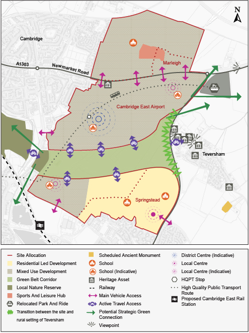
Figure 53: Indicative Spatial Framework for S/CE: Cambridge East.
Supporting information
3.2.3. This policy is required to enable the continued development of the site as a comprehensive new city district, to ensure the development of the airport site will integrate with Marleigh and Springstead Village, as originally envisaged in the Cambridge East AAP. The policy seeks to reflect the significance of the opportunity that this site offers to provide a sustainable new city district for East Cambridge that is transformative for the city.
3.2.4. Underpinning the future development will be a place book. It will establish a shared vision for the site and articulate the place-making principles, outcomes and quality expectations that will guide its planning, design and delivery. It will set out the characteristics, ambitions and defining qualities that are intended to shape the new settlement, whilst demonstrating how key themes such as movement, green and blue infrastructure, land use, community infrastructure, health and wellbeing, climate resilience, governance and stewardship should work together to create a sustainable, distinctive and well-connected place.
3.2.5. The place book will provide the foundation for subsequent spatial planning and design work, informing the preparation of a site wide masterplan, together with parameter plans, a strategic design code, place briefs and detailed design codes. These documents will translate the vision, principles and outcomes established through the place book into a coherent spatial structure and development framework capable of phased implementation whilst maintaining a consistent and high-quality sense of place throughout the lifetime of the development.
3.2.6. The indicative Spatial Framework for Cambridge East sets out an indicative high level illustration of the policy requirements that are location-specific within the site. Noting remaining uncertainties regarding the type, mix and siting of development, in particular that a masterplanning exercise has yet to be completed by the landowner, the framework is subject to change.
3.2.7. Cambridge East is an important location for meeting Greater Cambridge’s long-term housing needs, including those for specific groups such as older people, those with disabilities and travellers. For employment, the site is well located to be successful as a significant scale new cluster for office and laboratory space in the eastern part of the city, and has a key role to play in meeting Greater Cambridge’s significant need for industrial space, being well located to meet demand for mid-tech and general industrial uses.
3.2.8. The development should contribute to wider leisure and cultural provision in Cambridge. To diversify the offer for both leisure and culture and contribute to creating spaces for creative industries to grow. This should include developers engaging with local creative production groups to provide a mix of creative work, production and leisure spaces, including provision of a community arts centre. The development of this will be supported by a number of local stakeholders. The provision of the swimming pool at Cambridge East would be delivered by the Council with S106 contributions from developers at Cambridge East predominantly for a 4-lane 25 metre swimming pool contribution to the 10-lane regional swimming pool located at Cambridge East. This would also be part funded by S106 contributions from across Cambridgeshire and third party funding, such as Sport England.
3.2.9. In addition to the above, the Greater Cambridge Infrastructure Delivery Plan (IDP) (2026) has identified that the site will require: two new primary schools with integrated nurseries; two new secondary schools; a new healthcare facility, approximately 1,250 square metres community space, and 440 square metres library space to be delivered as a key library; a fire operational drop off point; and a sports hall (4 badminton court sizes), to support the delivery of the site during the plan period and beyond. The exact quantum and phasing of infrastructure will need to be kept under review as the development comes forward, including phases beyond the plan period. This should be informed by on-going engagement with statutory bodies and undertakers.
3.2.10. The policy sets out clear expectations for placemaking and the elements needed to deliver an exemplar development. Achieving a sensitive relationship between this site and its context will require careful consideration, recognising both the scale of opportunity, but also the need to respond to the existing townscape and landscape, including integrating well with Marleigh and Springstead Village, and being sensitive to retained historic assets on the site, the setting of Teversham Conservation Area, and with the wider townscape and landscape. Development should be of a density to support liveability while enforcing local character and architectural quality, ensuring taller buildings make a positive contribution to the Cambridge skyline in line with the Greater Cambridge Skyline and Tall Buildings Strategy.
3.2.11. Cambridge East has a long history of aviation which contributes significantly to the character and identity of the site. The Listed Control and Office Building is a designated heritage asset whose retention and appropriate setting should be conserved and enhanced through redevelopment. The site also contains a range of other potential designated or non-designated heritage assets associated with former airport uses. The significance and appropriate treatment of these assets will be informed by further heritage assessment and ongoing engagement with the Councils and Historic England. Development proposals should respond positively to the site’s aviation heritage and historic environment as part of the masterplanning process.
3.2.12. Reflecting and maintaining an important part of Cambridge’s identity, the site will ensure an extension of Coldham’s Common eastwards using the Green Belt corridor. The corridor’s Green Belt designation reflects its wider structural significance within Cambridge as forming one part of a green corridor into Cambridge – a key feature of the historic city. The current boundaries of the Green Belt corridor are retained for the purposes of this Local Plan. The current boundaries reflect a uniform width of the Green Belt corridor of 300 metres over its whole length. When the Cambridge East development is built out, it is not necessary or expected that the Green Belt corridor will be of that or any uniform width, indeed it is not considered appropriate for the corridor to take that form.
3.2.13. As envisaged in the Cambridge East AAP including the inspector's report, the ultimate boundaries of the Green Belt in this area are expected to be an output of a masterplanning exercise, which has yet to be completed. As such, the current boundaries of the Green Belt corridor will remain unchanged in this Local Plan but, following completion of the masterplan-planning exercise, precise boundaries to reflect the masterplan will be confirmed via a review of the Local Plan. In the event that the masterplanning exercise is completed and a planning application for development affecting the green corridor is made before the conclusion of a review of the Local Plan, any development within the corridor will be determined having regard to extant development plan and Green Belt policy.
3.2.14. If it is demonstrated via the masterplanning process that locating some development within the retained Green Belt corridor is necessary to achieve high quality placemaking, this may amount to a consideration that could in principle contribute to a finding of very special circumstances to justify grant of planning permission for that development. In such a case, it will be necessary to show, as part of any planning application, that the function of the Green Belt corridor is maintained or enhanced. Should the masterplan result in development encroaching on the current Green Belt corridor, there may be a requirement for additional widening of the corridor elsewhere in order to maintain the Green Belt function of the corridor. The physical boundaries of the Green Belt corridor should be considered and determined through the masterplanning exercise.
3.2.15. The recreational demands for green spaces arising from residents and workers at Cambridge East will be significant. Responding to this, the policy requires provision of green infrastructure throughout the site. In addition, to provide for recreational demands arising from residents and workers here – in particular to limit additional recreational pressure on the nearby Wilbraham Fen SSSI and Stow-cum-Quy SSSI - there is a need to provide recreational routes of different lengths for walking, wheeling and riding in all directions adjacent to development at Cambridge East. The green corridor will play a key role in meeting such needs but there is also a need to enable routes in other directions adjacent to the site. Beyond this, and noting the need to avoid directing significant numbers of visitors to Wilbraham Fen, the main opportunity to provide strategic scale off-site green space is to the north of the A14, associated with the Wicken Fen Vision. The National Trust is setting out clear plans to deliver green connections and space around Anglesey Abbey to deliver on this Vision in the coming years. The policy therefore requires development both to make a clear recreational connection towards that area, and to contribute financially towards the project, noting that the land in this area is beyond the control of the landowner at Cambridge East.
3.2.16. The policy sets out expectations to enable movement around the new city district and beyond to destinations such as Cambridge city centre, without overburdening the existing network and in a sustainable way. It is imperative that the mix of development supports an intergenerational community and achieves optimal transport outcomes including high levels of site and city trip internalisation and high active and public transport mode shares. The vehicular ‘trip budget’ referred to in the policy is a critical tool for achieving this. The indicative trip budget is approximately 1,500 trips in the AM peak and 1,800 trips in the PM peak. The trip budget will be refined as more detailed evidence is completed, and a strategic and local transport mitigation plan must be prepared to demonstrate the necessary measures for the development to achieve the resultant sustainable travel mode shares. Among other elements, this transport mitigation plan must include a parking strategy to demonstrate appropriate provision of cycle and car parking, including models of operation, such as rental of residential car parking to discourage private car ownership, and the accommodation of micromobility parking at key locations. It is noted that extant trip making from the site can be used to support a first phase of development. Monitoring will ensure full accountability and if necessary further mitigation, or refocussed mitigation which may be needed to ensure that overall compliance with the trip budget is achieved. The full detail of these mechanisms will be established in the s.106 obligations entered into on the grant of outline consent.
3.2.17. The Cambridge East allocation recognises the strategic opportunity presented by a potential Cambridge East railway station promoted through the East West Rail programme. The delivery of any new station and associated rail infrastructure will be subject to a separate statutory consent process outside the control of the Local Planning Authority. Accordingly, the allocation does not depend upon delivery of the station in order for development to proceed or function effectively.
3.2.18. Notwithstanding this, any future masterplan will need to respond positively to the potential future station by safeguarding its delivery, ensuring development does not prejudice future rail infrastructure, and establishing an urban structure capable of supporting rail connectivity should it come forward. The spatial strategy and movement framework in such a masterplan must retain sufficient flexibility to integrate a future station. Higher-density mixed-use development, including the district centre, should be capable of aligning with a potential station location to the south of the allocation, supporting transit-oriented development principles while ensuring early phases operate successfully in advance of any station delivery.
3.2.19. Such an approach will maximise long-term sustainable transport opportunities, improves accessibility across the eastern edge of Cambridge, and ensures the allocation remains effective and deliverable irrespective of the timing of the separate rail consent process.
3.2.20. The final phase of Marleigh was granted planning permission in July 2025 (23/04930/REM & 23/04936/FUL) taking to overall development to 1,391 dwellings, slightly more than granted in the consented 1,300 in the outline application (S/2682/13/OL). Springstead Village was granted outline planning permission for residential-led development with up to 1,200 dwellings (18/0481/OUT & S/1231/18/OL) in 2020. A reserved matters application for Phase 4 (23/03347/REM) was approved in April 2024. (Note: subsequent to the planning permissions being granted planning use classes have been updated; the updated use classes are referenced in the policy). Construction work has commenced on both sites, and some homes are occupied. In addition to the consented development at Springstead Village, engagement with the developer confirms that an additional 350 dwellings can be delivered within the existing red line boundary whilst still meeting the requirements of the permission.
3.2.21. These sites were able to progress as early phases of the full development that could come forward while the airport is still operational. Any future development proposals must be in accordance with the approved masterplan and design code. Proposals at Springstead Village (formerly known as Land North of Cherry Hinton) must also have regard to the Land North of Cherry Hinton Supplementary Planning Document, adopted in December 2018.
3.2.22. The Grafham Water Transfer is anticipated to be operational from 2032, supplying additional water to Greater Cambridge and easing resource pressures. The housing trajectory accompanying the plan anticipates housing completions from 2032.
Tell us what you think
For further guidance on how to submit comments, please see the Representation Guidance Note.
All comments must be received by 25 September 2026 at 5pm.