Policy S/GF: Land adjacent to A11 and A1307 at Grange Farm
1. A new settlement of approximately 4,500 homes delivered from 2034, subject to the necessary water infrastructure being available, approximately 35,000 square metres gross internal area (GIA) of employment floorspace, with a range of supporting services and facilities including retail, community, cultural, faith, leisure, education and sports and open space uses. The built area of the expansion will be contained within the site allocation boundary identified on the Policies Map.
2. A site wide masterplan will be prepared by the landowners and/or promoters in conjunction with the Council and in consultation with the local community and other stakeholders. The masterplan should be broadly aligned with the indicative Spatial Framework shown at Figure 68 and will need to identify the broad distribution of land uses, infrastructure delivery and phasing and will be used as a basis for the consideration of subsequent planning applications. The masterplan should be agreed by the Local Planning Authorities prior to the approval of any planning applications (and may be subsequently updated by the landowners and/or promoters and agreed by the LPAs).
3. Given the scale and long term construction of the development, a site wide place book shall be prepared to establish the vision, placemaking objectives and quality expectations for the new settlement and provide the foundation for the site wide masterplan and design codes. The design code will ensure that each phase of development positively contributes towards the high-quality placemaking outcomes expected.
Objectives and place identity
4. Grange Farm will be a thriving and sustainable new settlement, providing a distinctive mixed use development shaped by a comprehensive and innovative approach to delivering resilient placemaking. It will be delivered through a design led approach with nature and community at the heart of development.
5. Located within the Rural Southern Cluster, a globally important cluster of science innovation, Grange Farm will play a vital role in locating high quality new homes close to existing employment areas, connected through a holistic active travel and public transport network. At its core, it will be a vibrant place that provides for the day-to-day health, wellbeing, and quality of life needs of new residents, workers, surrounding communities and visitors, by positioning new local centres, schools, community uses, and other local services and amenities close to homes.
6. The new settlement will play a critical role in extending the Cambridge South East Transport (CSET) scheme, with a new segregated connection proposed which would also enable potential future extension of the proposed scheme to settlements further afield.
7. Development will need to respond to the surrounding character and context whilst maintaining a distinction with other surrounding settlements, in part through the preservation of the existing distinctive local characteristics of the built and natural environment.
8. The proposed Grange Farm site sits alongside the S/SEA/GF non-development areas adjacent to Grange Farm referred to as the Strategic Enhancement Area. The Strategic Enhancement Area sets out to ensure sufficient separation from neighbouring settlements and maintain a soft, green landscape to protect the development’s rural setting. These areas will also be used to deliver other associated uses, including new habitats, biodiversity and informal open space.
9. Grange Farm contains and is close to a number of nationally significant ecological and heritage assets, including the Worstead Street Roman Road Scheduled Monument and SSSI to the north, County Wildlife Sites, an extensive network of archaeological remains and features, various listed and non-designated heritage assets as well as the Great and Little Abington Conservation Area to the south. The future layout of the new town will consider these assets, identifying and implementing measures that mitigate impacts but also deliver enhancement wherever possible, including creating an extensive network of ecological corridors.
Uses
10. Land adjacent to A11 and A1307 at Grange Farm is allocated for mixed use development within the developable area of 198.2 hectares.
11. Development proposals must make a positive and meaningful contribution to the creation of a fully functional, self-contained new settlement. To achieve this, the site is allocated for mixed use development comprising:
a. Approximately 4,500 homes (to deliver 2,550 homes by 2045 subject to the necessary water infrastructure being available), including:
i. affordable housing, self and custom build homes and key worker housing to support surrounding employment sites;
ii. 10% of the total homes as specialist accommodation (within Classes C2 and C3), particularly for older people or those with disabilities.
b. A total of 12 Gypsy and Traveller pitches (within a site of approximately 1 hectare) provided on site or be located off site in compliance with Policy H/GT;
c. Approximately 20,000 square metres (GIA) Class B2 (General Industrial) floorspace and Class B8 (Storage or Distribution) through provision of a local last-mile logistics hub/warehousing;
d. Approximately 15,000 square metres (GIA) office (E(g)(i) floorspace to meet local needs generated by the new settlement;
e. A mix of retail, commercial, cultural and community facilities, indoor and outdoor leisure provision provided at new centres to meet the needs of the development;
f. Education facilities to meet the needs of the development including early years, primary and secondary schools, and for special educational needs, including three primary schools and a secondary school that are operational from the early phases of development;
g. Sports provision including a sports hall and football pitches, and financial contributions to an offsite swimming pool and other regional sports facilities;
h. Healthcare facilities to meet the needs of the development;
i. High quality open space and recreation provision, including parks, community gardens and food growing spaces;
j. Delivery of uses in the Strategic Enhancement Area, including:
i. Agricultural uses through sustainable management practices that provide for Biodiversity Net Gain, protect priority habitats and species, prevent erosion of the land and its quality, and provide other long term environmental benefits;
ii. Sustainable drainage systems (SuDS) such as swales, wetlands and reed beds;
iii. New habitats for wildlife and habitat compensation through the provision of same or better quality habitat conditions including grasslands, chalklands, and meadows;
iv. Informal open green space that provides recreational function and opportunity to access nature, biodiversity and foraging; and
v. Introduction of dark corridors where necessary to mitigate impacts on protected species.
The development of Land Adjacent to A11 and A1307 at Grange Farm must do the following:
Context
12. Embed exemplary principles for delivering high quality landscape, townscape, conservation and enhancement of heritage into all phases of masterplanning and design that will:
a. Ensure the development respects, protects and enhances the landscape within its rural setting, including surrounding chalk hills and woodlands;
b. Respond sensitively to the local townscape and heritage, incorporating appropriate buffers where appropriate and necessary, including the:
i. Worstead Street Roman Road Scheduled Monument to the north;
ii. Bronze Age Barrow Cemetery Scheduled Monument to the west, and north west of Grange Farm Cottage;
iii. Grade II listed Worsted Lodge Farmhouse immediately to the north-west and Grade II Listed 8 Cambridge Road immediately to the South;
iv. Non-designated heritage assets of Grange Farm;
v. Nearby Great and Little Abington Conservation Areas and associated Listed Buildings; and
vi. Known and unknown archaeological assets.
c. Establish a robust landscape framework that integrates the development with the Strategic Enhancement Area (S/SEA/GF) and the wider landscape context, informed through preparation of a Landscape Visual Impact assessment. This should include the enhancement and extension of the existing tree line along the southern edge of the landscape buffer to provide screening from the development area;
d. Given the area's potential for archaeological activity across the whole site, especially along the Roman Road and around the barrows, which are designated heritage assets, development proposals must be accompanied by an appropriate archaeological assessment which includes information on the significance of the heritage asset, including the extent, character and condition of the archaeological resource and the likely impact of the development on the archaeological remains and their character and setting. An archaeological Desk Based Assessment is required as a starting point; this should establish any further archaeological investigations required to establish a robust baseline from which to assess the impact of the proposed development on the designated and non-designated archaeological resource. These investigations and the Desk Based Assessment must inform the masterplan;
e. Undertake a Historic Landscape Characterisation and Landscape Character Assessment, and a more detailed Heritage Impact Assessment, to understand the impacts of development on landscape character, long range and local views and heritage assets and their setting, identifying appropriate mitigation and enhancement measures. The Council’s HIA and the results of these further assessments must inform the masterplanning for the site;
f. Improve the understanding and legibility of Worstead Street Scheduled Monument and links to other Roman networks through interpretation and public art; Maintaining appropriate separation between Grange Farm and surrounding existing settlements, including Little Abington and Babraham; and
g. Respond appropriately to the indicative edge boundary treatment to the north of the site as set out in the indicative Spatial Framework through a comprehensive evidence base demonstrating how any access infrastructure or development near to the northern edge towards the Roman Road, or SSSI will mitigate the impacts on the setting and significance of the heritage asset of the Roman Road, landscape and ecology.
Built form
13. Take a design-led approach that demonstrates how the development will:
a. Contribute to creating a thriving place, with access to key services and facilities that will support the community and surrounding villages from the outset;
b. Respond positively to key landscape, heritage, townscape and ecological features (identified elsewhere in this policy), and how these will be afforded appropriate protection and enhancement;
c. Deliver buildings that respond to the surrounding context and ensure heights of taller buildings do not adversely impact sensitive views, heritage assets and the setting or character of surrounding communities, particularly considering scale, density, massing and form at the northern area of the site, where densities should be limited to reduce impacts on the Worstead Road Roman Road;
d. Provide for an appropriate variety of typologies, scales, massing and densities across the site;
e. Identify landmark features and buildings that aid legibility and create a sense of identity within the new development;
f. Maintain the distinction between Grange Farm and neighbouring villages, in terms of character and physical separation;
g. Deliver exemplar design quality, reflecting the site’s prominent location and close association with nearby research campuses;
h. Be sensitive to the views to Gog Magogs from the highest points in the site and sensitively respond to the views to Ely Cathedral;
i. Protect the character of the Eastern boundary including retaining agricultural uses in this area;
j. Not build on or around the Listed Barrows to protect the barrows and their setting.
k. Deliver a network of new centres for the settlement, specifically:
i. A vibrant local centre supported by a critical mass which will act as a landmark for community and civic facilities and amenities and be the main focus for commercial and retail uses;
ii. Neighbourhood centres, serving day-to-day need for key services, education and community facilities in close proximity to homes; and
iii. Walkable town centres that are within a 15 minute walk of residential areas.
l. At these centres, buildings and main entrances provide an active frontage to the public realm and make a positive contribution to the street scene and wider placemaking objectives.
14. Deliver an appropriate mix of well-designed, high-quality residential neighbourhoods to meet a range of needs, incorporating:
a. A range of typologies, including terraced houses, semi-detached and mews housing, that support compact and walkable neighbourhoods;
b. An indicative average density of 30-40dph on the edge of the site to respond to the appropriate edge treatment with higher density development at an average range of 50-60dph in the centre. The lowest topographical points of the site should provide areas of higher densities;
c. Homes that are adaptable to support the needs of future generations; and
d. A range of other uses at neighbourhood centres, embedded within neighbourhoods, providing key facilities, services and flexible community amenity uses (for example a community centre that provides social benefit including sport and recreation), and cultural facilities, such as creative arts spaces, venues, within a short walking or wheeling distance of homes. Indoor and outdoor sports facilities, to meet the needs of the development, should be quantified and phased in accordance with an agreed Sports Strategy.
Public space
15. Establish a high quality public realm that encourages healthy lifestyles, physical activity and positively contributes to wellbeing, including legible and well-lit routes that enable safe walking and wheeling throughout the day and night.
16. Provide open space comprising formal children’s play space, informal children’s play space, informal open space, food growing, allotments and community orchards.
17. Integrate green and blue infrastructure into the design of the public realm including by providing places for people to interact, play and rest in nature.
18. Anchor the heart of development with high quality public realm focused around heritage and green infrastructure, that fosters a sense of community and co-locates active spaces such as parks, greens and outdoor spaces with local centres for people to gather formally and informally;
19. Create non-linear centres within the public realm to act as a focus for retail, community and civic uses for the town. This should be segmented into multiple blocks to allow for further expansion and should include a flexible cultural hub to anchor activity in the centre that should include:
a. Space to celebrate the archaeological assets of the site and the wider area;
b. Public spaces that should be capable of supporting regular markets including the provision of necessary market facilities for stallholders and visitors.
20. Deliver a network of clearly defined centres, providing for a range of co-located uses such as education provision, community spaces and/or facilities including faith spaces, food stores to meet day to day needs, cafés or public houses, green spaces and play areas embedded within the high quality public realm.
Nature
21. Preserve and enhance significant ecological heritage and the natural environment across the allocation, Strategic Enhancement Area (S/SEA/GF), and its surrounding context, that will:
a. Manage recreational pressure on areas of sensitive ecology and habitat including the impacts on the SSSI. This includes a buffer of chalk grassland for habitat creation. The design of the development should:
i. Prevent direct access onto the SSSI, including direct connections between the SSSI and the Roman Road PRoW. A strip of grassland should be used to create a buffer for the SSSI.
ii. Adopt a landscape-led design that supports the diverse ecological character and preserves the chalk hills and woodlands that are home to a species rich ecology;
iii. Maximise opportunities for ecological enhancement, such as through restoration of degraded habitats and reinforcements of ecological habitats and networks, including commuting, foraging and sheltering of species such as badgers, bats, hedgehogs and other mammals, birds, amphibians and invertebrates;
iv. Appropriately respond to the designated Scheduled Monument Roman Road and Alder Carr Site of Special Scientific Interest (SSSI) and its setting, River Granta and remnant lowland calcareous grassland of high floristic diversity to the northern boundary of the development, and non-statutory designations such as local wildlife sites within 2km distance of the development;
v. Ensure that appropriate measures are implemented to minimise recreational disturbance and pressures on ecology at the SSSI along the Worstead Roman Road which is a Public Right of Way and a European Long Distance Route;
vi. Support the long-term management and enhancement of the SSSI, including measures to support the restoration of the SSSI. This should include the long-term management of any new chalk grassland habitat;
vii. Create dark corridors (including along the SSSIs) to ensure nocturnal and crepuscular species are not disturbed, by providing minimal lighting near to the buffer of the development, and directional and movement sensitive lighting where appropriate;
viii. Preserve the existing range of watercourses and waterbodies of ecological significance and aquatic ecosystems, including the River Granta, a chalk stream that flows through Little and Great Abington;
b. Create a clearly defined green buffer between the neighbouring settlements which:
i. Preserves viewpoints from the northern, southern and eastern boundary of the site;
ii. Protects existing landscape features; and
iii. Extends and strengthens the existing treeline along the edge of the site; and the open character of the landscape buffer should be maintained.
22. To inform the design at all phases of development, the applicant must:
a. Carry out a full programme of ecological survey and monitoring, including detailed bat surveys, to guide a Biodiversity Implementation and Management Plan, providing appropriate mitigation and enhancement. This must include preparing site-specific ecological surveys to inform all phases of development, including strategic masterplanning, development of design detail (including dark corridors) and, where unavoidable impacts occur, appropriate mitigation. The species surveys should extend beyond the red line boundary to include the Roman Road SSSI and its surrounding habitat;
b. In considering connections between different designated and non-designated sites, prioritise retention of existing habitats and where protected species are shown to be present. Where retention is not possible, replacement habitat networks will need to connect designated sites and areas known to support protected species. The network – retained and extended – should, and be of sufficient quality to enable passage movement through the landscape unhindered, an important aspect of nature’s recovery and future resilience to climate change. These networks should be subject to appropriate positive management to maintain biodiversity value.
c. Retain and keep dark existing bat habitats. Any likely significant losses of, or damage to (including light pollution), habitats and the network should be avoided and considered through appropriate assessment.
d. Propose measures that will support the appropriate positive management of any ecological buffers, to maintain biodiversity value.
Movement
23. Deliver a comprehensive movement and connectivity network across the whole site that actively encourages and prioritises active travel and public transport providing connections across the site and to nearby villages and employment sites, and to key destinations within Cambridge, supported by residential, school and workplace travel planning. This outcome must be delivered by:
a. Ensuring the design of the site:
i. Prioritises walking, wheeling, cycling and public transport movements and provides a legible high quality street network;
ii. Focuses the movement network on the key areas of activity within the settlement, ensuring these are highly accessible by non-private modes;
iii. Integrates direct, safe, and efficient public transport routes, ensuring that all development is located within reasonable walking distance of mobility hubs served by high quality public transport;
iv. Promotes low car ownership, including through remote parking approaches such as rural car barns at the edge of parcels or plots;
v. Integrates secure, covered and conveniently located cycling parking throughout the settlement at mobility hubs, workplaces and public spaces.
b. Setting aside land for and/or directly delivering at least the following physical transport measures within the site:
i. Mobility Hubs / bus stops within 400m for all site occupants;
ii. A last mile logistics hub to enable delivery of goods from the distribution centre and supports the trip budget in reducing the number of trips through the development;
iii. Internal and local connections to the Linton Greenway, Byway 4/1 and Worsted Lodge access road.
c. Commensurate with the phasing of development, making financial contributions towards and, as appropriate, enabling the following transport measures:
i. High quality segregated active travel connections across the A1307 and A11 and along Newmarket Road to connect the site with Granta Park and the CSET Phase 2 Travel Hub and active travel path, to support the early phases of development;
ii. Improvements to wider walking and cycling infrastructure to Babraham, Babraham Research Campus, the Wellcome Genome Campus, Granta Park, Little and Great Abington, Linton, and Whittlesford Parkway Station, including addressing local severance from the A1307 and A11;
iii. The GCP Cambridge South East Transport (CSET) Phase 2 scheme which will provide a high quality public transport corridor and active travel route from the proposed A11 Travel Hub to the Cambridge Biomedical Campus, Cambridge city centre and the Linton and Sawston Greenways;
iv. Extension of the CSET Phase 2 public transport corridor and services directly into the site via a segregated link from the proposed Travel Hub across the A11 into the site, to support the early phases of development. This must be in place to support first occupation of the site, unless it can be demonstrated by the applicant through a detailed Transport Strategy and phasing plan (as agreed with the Local Planning Authority and, Local Highways that, to support first occupation, there is an alternative, temporary means of securing a frequent, reliable, prioritised public transport service providing fast, direct connections between the site and Cambridge Biomedical Campus, key nearby mobility hubs, and other key destinations in and around Cambridge. If a temporary approach is agreed, the agreed phasing plan must demonstrate an appropriate trigger for completion of the segregated link based on the development capacity supported by that temporary approach;
v. A package of bus service improvements providing links to Granta Park, Babraham Research Campus, Genome Campus, Cambridge Biomedical Campus, North East Cambridge, Cambridge railway stations (including Cambridge South and Whittlesford Parkway station), Linton and Haverhill;
vi. Bus priority measures along the A1307 between Haverhill and Cambridge, as required, including at Fourwentways junction;
vii. Necessary off-site highway mitigation and appropriate site access arrangements. Ensuring there is no direct access from the new settlement to the Worsted Road Roman Road, reflecting archaeological, heritage and ecological sensitivities.
24. The agreed masterplan for the site must demonstrate how:
a. the distribution and mix of development achieves optimal transport outcomes, maximising site internalisation and high active and public transport mode shares;
b. The quantum and mix of development can be delivered within the agreed trip budget. The Trip Budget will be refined as the site goes through the planning process and the final definitive trip budget must, based on detailed evidence, be agreed with the Local Highways Authority prior to submission of the outline application. A monitor and manage approach will be taken to ensure that the development remains within the agreed trip budget for the site throughout its delivery.
25. To support delivery of the agreed masterplan, a strategic and local transport mitigation plan must be prepared by the developer for agreement with the Local Highways Authority and Local Planning Authority. This must include:
a. Active and public transport measures;
b. Vehicular transport measures, including site access arrangements that avoid congestion on the A1307 during peak travel hours and appropriate local highway mitigation measures;
c. A comprehensive parking strategy aligned with low-car living objectives;
d. Infrastructure costing and delivery phasing, demonstrating how the necessary transport measures identified above will be delivered at a time that enables optimal transport outcomes and remains within the agreed trip budget;
e. Mechanisms for delivery, monitoring and review including potential delivery through Section 106 obligations, or CIL or other appropriate funding mechanisms.
Resources
26. As part of the design, consider innovative approaches to incorporating low-sustainable water management, including greywater recycling, rainwater harvesting, and sustainable drainage systems (SuDS), informed by preparation of an Integrated Water Management plan and Water Cycle Strategy.
27. Provide appropriate provision for and design of foul drainage and sewage disposal, to be explored and identified through a foul drainage strategy to be prepared by the applicant, in line with the Climate and Sustainability Innovation Delivery Plan.
28. A Site Specific Flood Risk Assessment is required to support the planning application and this must include modelling of Oakington Brook. No development should be located within 8 metres of Oakington Brook apart from permitted access.
29. Ecological survey and monitoring is required for specific sensitive locations outside of the site’s red line boundary that may be impacted by the development. This document should monitor the effectiveness of measures put in place to combat recreational disturbance on the SSSI, for example, and a commitment to implementing alternative solutions if the initial measures are ineffective.
30. Conditions are likely to be necessary to limit first occupations of new dwellings taking place until after the Grafham Transfer water supply intervention becomes operational or where alternative headroom is secured, in consultation with Cambridge Water and the Environment Agency, where the LPA is satisfied that there is scope for earlier development.
Lifespan
31. In addition to the requirements on the validation checklist, the following will be required at the submission of an outline or major planning application:
a. A comprehensive masterplan
b. A Place Book;
c. A cohesive stewardship strategy through early-phase community engagement including through conservation groups to deliver community-based enhancement stewardship as endorsed by Natural England;
d. A more detailed Heritage Impact Assessment;
e. A desk based Archaeological Assessment;
f. Landscape and Visualisation Assessment;
g. A Recreation Pressure Assessment for the SSSI;
h. A Conservation Management Plan for the heritage assets including the Roman Road;
i. A strategic and local transport mitigation plan (in consultation with the Local Highways Authority and Local Planning Authority); and
j. The approach to the long-term management, maintenance and stewardship of the new settlement, including its infrastructure, services, facilities and built and natural environment, must be identified at the outset through a Management and Maintenance Plan that sets out a comprehensive approach to the long-term management of the site as it evolves.
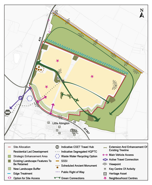
Figure 68: Indicative Spatial Framework for Policy S/GF: Land Adjacent to A11 and A1307 at Grange Farm.
Supporting information
3.3.48. This policy provides a consistent planning framework for managing new applications for development of this new settlement in the context of a new strategic allocation for site. The policy will ensure that new development is well integrated, whilst maintaining a separation from other nearby settlements, serves the needs of existing and future communities and mitigates the impact of development where required. Grange Farm will be developed during the period of the Local Plan and beyond.
3.3.49. The location of Grange Farm provides an opportunity to create a high quality and sustainable settlement that provides access to nearby employment centres such as Babraham Research Campus (S/BRC) to the north west, Granta Park to the south, and the Wellcome Genome Campus and Chesterford Research Park to the south west. Development will support these existing employment sites through provision of key worker housing, services and amenity provision and access to high quality green open spaces.
3.3.50. This policy is required to enable development of the site as a comprehensive new settlement, and provide a framework for consideration of future planning applications. Underpinning the future development will be a Place Book. It will establish a shared vision for the settlement and articulate the place-making principles, outcomes and quality expectations that will guide its planning, design and delivery. It will set out the characteristics, ambitions and defining qualities that are intended to shape the new settlement, whilst demonstrating how key themes such as movement, green and blue infrastructure, land use, community infrastructure, health and wellbeing, climate resilience, governance and stewardship should work together to create a sustainable, distinctive and well-connected place.
3.3.51. The place book will provide the foundation for subsequent spatial planning and design work, informing the preparation of a site wide Masterplan, together with parameter plans, a Strategic Design Code, Place Briefs and Detailed Design Codes. These documents will translate the vision, principles and outcomes established through the Place Book into a coherent spatial structure and development framework capable of phased implementation whilst maintaining a consistent and high-quality sense of place throughout the lifetime of the development.
3.3.52. The policy sets out clear expectations for placemaking and the elements needed to achieve this to a high standard whilst responding to significant historic landscape and heritage assets including the chalk hills and woodlands that are home to a species rich ecology.
3.3.53. The Strategic Enhancement Area is designed to form a buffer between the proposed and existing settlements to contribute to mitigating the impacts on landscape and heritage. There is a variety of high and low grade agricultural land that provides environmental benefits. The agricultural uses could be through grazing, crop production and cultivation of food and forestry and agro-forestry. The SEA could also accommodate infrastructure for the site with sufficient evidence to justify its deliverability and minimise impacts on heritage and SSSIs.
3.3.54. The indicative Spatial Framework identifies the indicative edge boundary treatment to the north of the site that highlights the importance of mitigating impacts on the setting and significance of the heritage asset of the Roman Road. The HIA sets out that development risks impacts on the Barrow Cemetery and Worstead Street Scheduled Monuments and the Worsted Lodge Grade II Listed Building to the north of the site. Development may also affect the rural setting of the Great and Little Abington Conservation Area and views to the north, and the Grade II Listed 8 Cambridge Road just south of the site. Mitigation is required to minimise or avoid these impacts. This includes managing development design to preserve the setting and character of the Worstead Street Scheduled Monument, the rural setting of Worsted Lodge, and the rural setting of the Barrow Cemetery Scheduled Monument. The setting of the non-designated Grange Farm building(s) will also require consideration. Additionally, development design should be managed to minimise urbanising effects on the Conservation Area and 8 Cambridge Road.
3.3.55. The site adjoins the Worstead Roman Road Scheduled Monument and SSSI. As a Scheduled Monument, there is the potential for the archaeological finds here to be of national significance. The Barrows in the South East of the site, which have the same weight as a Listed Asset from an archaeological perspective. The potential for significant archaeological remains on the site therefore triggers the requirement for a detailed site wide geophysical survey and Desk Based Archaeological Assessment (DBA) prior to the submission of a planning application to inform any future investigative works onsite in consultation with Historic England and Cambridgeshire County Council.
3.3.56. The DBA must be completed in line with the CIfA guidance and draws on a wider pool of information to pull together a detailed archaeological background of the site, and assessment of the significance of the assets. This evidence will inform the scope and requirements for further trenching, as agreed with County Archaeology and Historic England. The DBA and geophysical survey must inform the masterplan for the site. The indicative Spatial Framework for Grange Farm sets out an indicative high level illustration of the policy requirements that are location-specific within the site.
3.3.57. Currently, the site is bounded by the A11 to the west and the A1307 Cambridge Road to the south, which provides the existing access to the site, with a Roman Road (public right of way) to the northern boundary. To the west is access to the A1307, one of the main routes into the city of Cambridge, and the A11. The indicative Spatial Framework sets out the main vehicular access points at the south of the site and the potential option for further site access to the north west.
3.3.58. Any built form or infrastructure including the exploration of options for a northern access point should respond appropriately to the indicative edge boundary treatment through a comprehensive evidence base demonstrating how any access infrastructure or development near to the northern edge towards the Roman Road, or SSSI will mitigate the impacts on the heritage assets identified in the HIA, and the setting and significance of the Roman Road.
3.3.59. Housing should be of high quality design and be located nearby to centres across the settlement to enable access to amenities to support the day to day need of residents and visitors. Homes should provide a range of types and tenures and should include delivery of affordable housing, build to rent, and key worker housing. Homes should be built with a range of densities, with opportunities to densify around local and neighbourhood centres and create areas of lower densities nearby to perimeter of the settlement and areas of higher topography. This approach will support in creating critical mass whilst sensitively responding to the local context, character and topography of the site.
3.3.60. Community infrastructure should be implemented in early phases of development to ensure that the needs of the settlement are fulfilled. A range of social and leisure facilitates should be provided including community space, and facilities that are adaptable for different users including younger people, older people, and faith groups. Community spaces and centres should consider integrating library services within design to benefit the health and wellbeing of people living and visiting the settlement.
3.3.61. There is also opportunity to provide high quality cultural facilities, such as creative arts spaces, venues, and respond to the heritage and character of the area through public art. Indoor and outdoor sports facilities, play spaces and sports pavilions, will create access enable the community to access high quality provision on the site and meet the needs of the development. The design, layout and location of these spaces will be integral to their integration, and a comprehensive site-wide masterplan must identify where these will be located.
3.3.62. The Greater Cambridge Infrastructure Delivery Plan (IDP) (2026) has identified that the area will require the delivery of or financial contributions towards: a range of on-site, local and strategic transport infrastructure; reinforcements to existing primary substations, two New Primary Schools with Integrated Nurseries, one New Secondary Schools, 937.51 square metres of community space, 327.04 square metres of library floorspace, provision of a sports hall, financial contributions to a swimming pool offsite, a variety of outdoor sports facilities accessible green space to meet the demands from future residential and employment growth; and play space. The exact quantum and phasing of infrastructure will need to be kept under review as the development comes forward, including phases beyond the plan period. This should be informed by on-going engagement with statutory bodies and undertakers.
3.3.63. Walking, cycling, and public transport will be the primary modes of access, supported by a coherent and legible network of routes within the site. Development should enhance connectivity and integrate proposed the CSET scheme to reduce car dependency and improve access to public transport and active travel. Delivery of the CSET scheme will enable improved transport connectivity across the site and will reduce impact on the existing transport network in the area.
3.3.64. Implementation of an effective site-wide Travel Plan against the trip budget, that include measures such as site-wide micromobility, car-sharing, electric car clubs, and incentives to encourage travel by active and sustainable modes. An initial Trip Budget of 1,114 trips has been calculated for this site. The active travel should be prioritised to achieve this trip budget. A trip budget based on detailed evidence must be agreed with the Local Highways Authority prior to submission of the outline application. Monitoring will ensure full accountability and if necessary further mitigation, or refocussed mitigation which may be needed to ensure that overall compliance with the trip budget is achieved. The full detail of these mechanisms will be established in the s.106 obligations entered into on the grant of outline consent.
3.3.65. The Grafham Water Transfer is anticipated to be operational from 2032, supplying additional water to Greater Cambridge and easing resource pressures. The housing trajectory accompanying the plan anticipates housing completions from 2034.
Tell us what you think
For further guidance on how to submit comments, please see the Representation Guidance Note.
All comments must be received by 25 September 2026 at 5pm.