Policy S/CB: Cambourne
Objectives and place identity
1. Cambourne will continue to develop into a modern town that is well connected, sustainable, thriving and prosperous. Key to its continued success will be the integrated network of ecological and open spaces as well as a growing range of employment opportunities, services and facilities and active and public transport that will meet the day-to-day needs of the local community.
2. New development will be expected to positively contribute the housing, employment and community needs for the town, as well as local aspirations for a healthy, cohesive and proud community. A key priority will be ensuring the existing town integrates successfully with the proposed development to the north at Cambourne North, including its proposed Station Quarter as well as enhanced active travel connections to the surrounding villages to enable people to walk and cycle to services and facilities within the town.
3. Development and infrastructure proposals will need to protect, and where possible, enhance the setting of nearby heritage assets including Caxton and Bourn Conversation Areas, Caxton Moats and Pastures Farm Scheduled Monuments and listed assets including but not exclusive to New Inn Farmhouse, The Old Court House and Great Common Farmhouse.
4. As set out in the indicative Spatial Framework (Figure 67), Cambourne’s growth will be centred around three key areas:
a. Cambourne West;
b. Cambourne Business Park; and
c. Cambourne Town Centre.
5. There will also be a focus on delivering strong connectivity to Cambourne North (Policy S/CBN) and Cambourne Railway Station, to ensure the whole town is able to benefit from new facilities, amenities, employment opportunities and sustainable transport links.
Cambourne West
6. The new and fourth village to the town of Cambourne will continue to develop into a well-integrated, vibrant and sustainable new community, providing a range of housing types, employment opportunities, local facilities and open spaces. At the heart of the development will be a green spine, which will form a key part of the active travel and open space networks but also provide the framework for the community facilities, including schools, community spaces and new local centre.
7. It will be well connected to the wider area by public transport and active travel connections. The development will be embedded in a network of multi-functional green infrastructure, and support walking, cycling and public transport as the preferred mode of choice for travel.
Uses
8. Cambourne West is allocated for mixed-use development, comprising:
a. Up to 2,350 homes (1,585 homes to be delivered within the plan period), including affordable housing, older persons accommodation and self/custom build homes;
b. Employment uses up to 30,625 square metres (gross internal area) of mixed employment (Class E(g)) floorspace. These should be split between two parts of the development, as set out on the indicative Spatial Framework, to ensure good access to the A1198 for the western parcel and to compliment Cambourne Business Park for the eastern parcel;
c. Education facilities to include an additional primary school;
d. Community facilities of at least 645 square metres (GIA);
e. Retail uses of at least 1,550 square metres (GIA);
f. Indoor and outdoor leisure provision, play spaces and sports pavilion;
g. Open space including parks and landscaping;
h. Allotments;
i. The provision of small scale shops and other town centre uses to serve the needs of the development and adjoining Business Park. This must:
i. Include provision for convenience shopping needs with a store of up to 500 square metres (GIA), within 600 metres of the majority of homes; and
ii. Be supported by a retail assessment, submitted as part of any planning application, to demonstrate that the quantity of town centre uses proposed will support the needs of the development whilst not having a significant adverse impact on the vitality and viability of other centres including Cambourne Town Centre.
j. Safeguarded land within the existing and proposed school grounds to enable their future expansion.
The development of Cambourne North must do the following:
Context
9. Cambourne will continue to develop into a modern town that is well connected, sustainable, thriving and prosperous. Key to its continued success will be the integrated network of ecological and open spaces as well as a growing range of employment opportunities, services and facilities and active and public transport that will meet the day-to-day needs of the local community.
10. Provide a new central spine for new services and facilities to create community hubs that are well positioned to serve the community and adjacent neighbourhoods.
11. Protect and enhance the existing woodland belts to the north, south and west of the site, providing extensive screening to mitigate short and long-distance views. The woodland should be varied in width and provide breaks to afford views out where appropriate.
12. Ensure there is appropriate screening to avoid the sense of coalescence with Caxton and minimising views of the development from within the village.
Built form
13. Ensure that building heights and massing make a positive contribution to the wider landscape character of the area, with necessary mitigation measures implemented where adverse impacts are identified.
14. Provide satisfactory arrangements to control traffic noise from the A428 and A1198 which do not involve the use of acoustic fences and walls, such as gently contoured landscaped soil bunds.
Public Space
15. Provide landscape areas and green corridors to contribute to the informal recreation needs of those living, working and visiting the development including for informal children’s play.
Nature
16. Retain existing woods, hedges, unimproved grassland areas and water features, contributing to the character and amenity of Cambourne West. These must be:
a. Managed to enhance their ecological value;
b. Linked together by areas of open space, to provide a network of accessible green infrastructure both within the site and beyond; and
c. Planned with sensitive lighting strategies and provide dark habitats and/or corridors where possible.
Movement
17. Deliver a comprehensive and legible movement and connectivity network, connecting key areas of activity. The network design must facilitate a low car living approach, where walking, wheeling and public transport are the first choice for most residents, workers and visitors from the outset, supported by residential, school and workplace travel planning.
18. This outcome will be delivered by:
a. Ensuring the design of the site focuses the movement network on the key areas of activity within the site and the wider town, ensuring they are highly accessible and permeable by non-private modes:
i. Provides a series of well connected ‘walkable neighbourhoods’, each capable of meeting everyday needs, supported by clear, safe, convenient and legible routes and effective wayfinding within and between neighbourhoods. These walking and cycling routes should be segregated where required;
ii. Develops an improved rights of way network, making provision for walking, wheeling and horse riding, to support sustainable transport, recreation and health, and to connect the town to the wider countryside and settlements beyond Cambourne, including Papworth Everard, Caxton and Bourn Airfield;
iii. Includes a clear road hierarchy, including primary routes, and sustainable movement prioritised secondary streets and local access roads; and
iv. Promotes low car ownership.
b. Setting aside land for and/or directly delivering at least the following physical transport measures within the site:
i. Providing a highly accessible network of safe and convenient cycleways, segregated from other modes where appropriate, and to ensure covered, secure cycle parking facilities for homes, workplaces, the town centre, local centres and other places;
ii. Provision of a High Quality Public Transport Corridor (HQPT) route into and through the site, and a dedicated HQPT and active travel connection over the A428 to Cambourne North. New stops must be conveniently located to ensure all homes are within easy walking distance of a stop, whilst not compromising the level of service provision; and
iii. Creating an effective local bus route through the site to ensure that all homes are within easy walking distance of a bus stop.
19. Directly delivering, or where this is not possible, making financial contributions towards and, as appropriate, enabling the following transport measures external to the site:
a. Any measures necessary to ensure that these journeys between Cambourne West and the junction of the A428 and the A1303 is direct and unaffected by any congestion suffered by general traffic;
b. A financial contribution towards the Cambourne to Cambridge public transport corridor, secured through a S106 agreement;
c. Providing high quality segregated bus priority measures on the A1303 between its junction with the A428 and Queens Road, Cambridge;
d. Addressing the impact of the proposals on the junctions of the A428 with the A1303 and the A1198, which must be assessed in detail and contributions towards or direct funding of improvements to the junctions secured through a legal agreement where required;
e. Delivery or funding of any measures required to mitigate the traffic impact on Bourn, Caldecote, Toft, Comberton and Barton; and
f. Vehicular access to be provided through an enhanced route through the Business Park, one or more access points from the Caxton Bypass, and via Sheepfold Lane.
20. Coordination will be required with other developments on the A428 corridor to deliver the necessary improvements.
21. To support delivery of the agreed masterplan, a strategic and local transport mitigation plan must be prepared by the developer in consultation with the Local Highways Authority and Local Planning Authority. This must include making financial contributions towards and, as appropriate, enabling any other transport measures necessary to make the development of the site acceptable in transport terms, as evidenced at planning application stage;
a. Sustainable and public transport measures;
b. Vehicular transport measures, including site access arrangements;
c. A comprehensive parking strategy aligned with low-car living objectives;
d. Infrastructure costing and delivery phasing; and
e. Mechanisms for delivery, monitoring and review including potential delivery through Section 106 obligations, or CIL or other appropriate funding mechanisms.
Resources
22. Create a water attenuation network, to support sustainable water management and deliver ecological benefits.
23. Ensure the provision, management and on-going maintenance of sustainable surface water drainage measures.
24. Make appropriate arrangements for foul drainage and sewage disposal, to be explored and identified through a Climate and Sustainability Innovation Delivery Plan and a Foul Drainage Strategy. Make satisfactory arrangements, set out in a Construction Strategy (to be approved by the Local Planning Authority), in relation to site accesses, haul roads, construction traffic routes, storage compounds, use of plant and machinery, working days and hours, and retention of construction spoil on site. This must ensure that construction vehicles do not travel through nearby villages or have an adverse effect on biodiversity.
25. Development should not preclude operation and maintenance of sewer pumping stations located within or adjacent to the site.
Lifespan
26. The applicant must ensure the provision, management and maintenance of infrastructure, services and facilities to meet the needs of the development which are not met by a statutory undertaker.
27. Undertake a Landscape Visual Impact Assessment and Heritage Impact Assessment to understand the impacts of development on landscape character, long range and local views and heritage assets and their setting.
28. As part of future planning applications, the applicant must provide management and maintenance plans for:
a. Landscaping and open spaces;
b. Community buildings;
c. Indoor and outdoor sports facilities;
d. Unadopted roads; and
e. Parking enforcement.
Cambourne Business Park
29. Cambourne Business Park will be an employment led, mixed use quarter, providing a mix of employment opportunities, new homes, open spaces and supporting facilities. The site will become a lively and integrated part of the town, connecting Cambourne West and Cambourne Village College with the wider town to the east complimented by a mix of activities beyond the working day.
Uses
30. Cambourne Business Park is allocated for mixed use development, comprising:
a. Approximately 256 homes (all to be delivered within the plan period), including affordable and self and custom build homes;
b. Approximately 4,000 square metres (GIA) office (Class E(g)(i)) floorspace utilising existing undeveloped plots;
c. Appropriate supporting ancillary uses and infrastructure, including retail uses of 109 square metres (GIA) through the reuse of the marketing suite; and
d. Open space including parks and landscaping.
Development proposals for Cambourne Business Park must do the following:
Context
31. Be in accordance with the Cambourne indicative Spatial Framework and approved masterplan (or any successor documents). Any new or amended masterplan must demonstrate how the development will integrate with the rest of the town, including Cambourne North, Cambourne West and the Town Centre;
32. Safeguard the existing undeveloped plots for office floorspace and ensure that adjacent development proposals do not preclude this use from coming forward in the future.
Built form
33. Ensure the height and massing of commercial buildings are carefully designed to avoid adverse impacts on local and wider views and complement residential blocks elsewhere on the site.
Public space
34. Create a network of green spaces within the wider development, which integrate well with existing and proposed development, contribute to legibility and contribute to the attractiveness of the place.
35. Provide hard and soft open spaces throughout the development that are multifunctional and accessible to those living at, working on and visiting the site.
Nature
36. Provide a high degree of connectivity between the existing and proposed green spaces and ecological assets.
37. Ensure retention and enhancement of the existing tree belts along the boundary of the site and within individual plots.
38. Be in accordance with a landscape strategy for the site, prepared by the applicant and approved as part of the planning application.
Movement
39. Provide a comprehensive and legible network of streets and paths which allow for easy access into and through the site.
40. Seek to minimise the use of private vehicles through the provision of active travel measures and bus routes passing through the site.
Lifespan
41. As part of future planning applications, the applicant must provide management and maintenance plans for:
a. Landscaping and open spaces;
b. Indoor and outdoor sports facilities;
c. Unadopted roads; and
d. Parking enforcement.
42. The applicant must prepare and adopt a management strategy to ensure high quality, robust and effective implementation, adoption and maintenance of the biodiversity areas.
Cambourne Town Centre
43. Cambourne Town Centre will continue to develop into a thriving centre, which contains a mix of shops, employment floorspace, community uses and homes. It will become a place for people to visit on foot, bicycle and by public transport to meet their daily needs and provide opportunities for people to meet and dwell.
Uses
44. Cambourne Town Centre is allocated for mixed use development, comprising:
a. A range of residential dwelling types and tenures, including affordable and self/custom build homes, including approximately 120 homes on Cambourne High Street (all to be delivered in the plan period);
b. A range of flexible retail units (Classes E(a-c) and E(e)) that meets the day-to-day needs of the local community; and
c. Community, cultural, dedicated faith and commercial leisure uses.
Development proposals for Cambourne Town Centre must do the following:
Context
45. Demonstrate a comprehensive and coordinated approach to redevelopment, maximising opportunities to:
a. Enhance the existing town centre through the provision of social, cultural, retail and commercial development that supports the existing and future needs of the town;
b. Provide mixed-use development that incorporates living, working, and leisure to create a dynamic, human-scaled environment;
c. Optimise the town centre through the redevelopment and/or intensification of existing undeveloped plots and surface car parking.
Built form
46. Provide active frontages and high quality public spaces to enhance the vibrancy of the town centre and provide places for community events to take place and people to socialise and meet.
47. Identify opportunities to co-locate services and facilities to minimise the need for people to travel.
48. Provide flexible retail spaces than provide for small scale, independent, retailers and space for businesses to expand.
49. Explore opportunities to convert or repurpose existing large retail units for mixed use development.
Public space
50. Provide an integrated network of parks, squares, play spaces and water features, that seamlessly joins with and is accessible to the wider strategic open space network.
51. Provide community food growing, informal play and health-focused green spaces.
Nature
52. Embed nature across all development typologies, including green roofs, trees, habitat corridors and urban greening.
53. Create a landscape buffer using the Strategic Enhancement Area around the northern boundary of the site to create separation between neighbouring settlements and preserve and enhance the existing Ancient Woodland and SSSIs.
Movement
54. Prioritise active and sustainable travel in the design, enabling safe, accessible, and attractive movement for all users by:
a. Prioritising walkable neighbourhoods, low traffic streets, and excellent public transport connectivity;
b. Support a comprehensive, direct, legible network for walking and cycling, integrated with green space and public realm;
c. Seeking to exceed minimum cycle parking standards, ensuring they are secure, covered and conveniently located throughout the area, including integrated into mobility hubs, workplaces and public spaces;
d. Making sufficient provision for bus services as part of the design and layout of the highway and adequate waiting provision for passengers, including shelters and seating;
e. Providing or contributing towards enhancements in public transport that deliver improved connections within Cambourne and to nearby settlements and maximise the benefits of proposed new infrastructure, such as the Cambourne to Cambridge public transport corridor ;
f. Consolidating car parking, including exploring multi-storey car parking, to achieve high quality placemaking outcomes and make more efficient use of land in a sustainable location;
g. Restricting on-street parking through design to prioritise public realm and active travel; and
h. Incorporating a delivery and consolidation hub to reduce vehicle trips into the centre and support sustainable logistics.
55. Parking displacement within 1km must be monitored and development may be paused until suitable mitigation (such as Controlled Parking Zones) is implemented.
Lifespan
56. The applicant must demonstrate a coordinated and comprehensive approach to redevelopment of the town centre, either:
a. Through the preparation of a comprehensive masterplan to maximise its potential; or
b. Where this is not feasible, site-level masterplans must be prepared demonstrating how they satisfactorily align with adjacent sites.
57. Applications must be supported by:
a. Parameter plans for land use, density, height, movement and green infrastructure;
b. A design code guiding quality, form and materials;
c. A phasing and infrastructure delivery plan aligned with key triggers; and
d. A stewardship strategy to ensure long-term maintenance and governance of public realm and facilities.
58. The applicant must engage meaningfully with local communities and stakeholders through every stage.
59. Any proposals will be subject to independent design review, with updates to the Design Code as phases evolve.
Connections to Cambourne North (Policy S/CBN) and Cambourne railway station
60. In line with Policy S/CBN, there will be a focus on the integration of Cambourne North with the existing town and High Street, addressing potential barriers to movement, including the A428 and proposed East West Rail route, though a comprehensive movement network for walking and cycling, including a series of new connections and improvements to the public realm.
61. Cambourne and Cambourne North (Policy S/CBN) will be planned as one town. Critical to its success will be the ability for people to move seamlessly between the two parts of the town by active travel and public transport as well as private vehicle where necessary. As identified on the Cambourne indicative Spatial Framework, a number of connections must be delivered over the A428 between Cambourne and Cambourne North. These must:
a. Deliver a design which makes a positive contribution to the sense of place, forming part of the place identity for the town and be of high architectural merit, exceeding minimum technical standards in relation to width;
b. Be phased to align with the opening of the railway station and other planned phases of development;
c. Form part of the movement and green infrastructure network, ensuring they provide safe, convenient and seamless links either side of the A428 which are suitable for pedestrians, cyclists and other forms of non-motorised transport. Segregated walking and cycling provision should be sought to mitigate user conflicts and enable safe and convenient provision;
d. Provide sufficient ecological corridors, connecting with ecological assets and wider networks on both sides of the A428; and
e. Incorporate careful consideration of lighting to avoid unnecessary light pollution and subsequent adverse impacts on dark corridors.
62. Improvements will be sought to create new and/or improve existing pedestrian and cycling facilities between Cambourne Town Centre and Cambourne Railway Station. This includes highways, junction and crossing improvements to Cambourne Road between the A428 ‘dumbbell roundabout’ and the roundabout north of Great Cambourne so they are designed around active and sustainable travel, enabling safe, accessible, and attractive movement for all users. New or enhanced connections must not conflict with, or prejudice the delivery of, East West Rail proposals.
63. Where the provision of new strategic infrastructure results in the loss of open space, landscape features and/or ecological habitat, these will be required to be replaced with enhanced provision within the town.
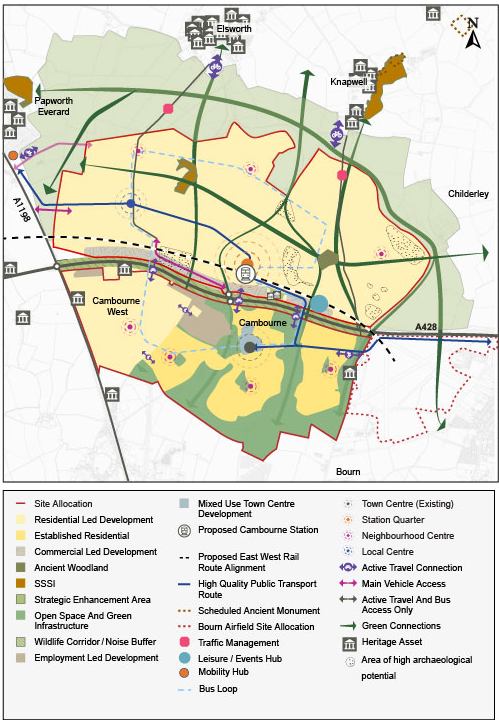
Figure 67: Indicative Spatial Framework for Policy S/CBN: Cambourne North and Policy S/CB: Cambourne.
Supporting information
3.3.31. Over the past 25 years, Cambourne has developed into a well-established community, where local people have access to a range of local services and facilities including a network of open spaces, sports clubs and successful schools. At the heart of the town is the local community who play a key role in supporting and delivering these essential local services. This is in spite of the lack of High Street within the town, where the town centre is dominated by large retail units and surface car parking.
3.3.32. This policy provides a consistent planning framework for managing new applications for development within the town, in the context of a new strategic allocation for expansion of the settlement at Cambourne North. It incorporates a holistic vision for the development of Cambourne as a whole, to ensure that new development within the existing town and the expansion area to the north are well integrated and serve the needs of existing and future communities.
3.3.33. The Greater Cambridge Infrastructure Delivery Plan (IDP) (2026) has identified that the site, in combination with Cambourne North, will require the delivery of or financial contributions towards: Upgrade to increase capacity at Uttons Drove WRC, two new primary schools with integrated nurseries; one 8FE secondary school, a on-site healthcare facility, approximately 983 square metres community space, 342 square metres library space to be delivered as a hub library; provision of 206 square metres of swimming pools, a sports hall (four badminton court sizes), and a range of outdoor sports pitches to support the delivery of the site during the plan period and beyond. The exact quantum and phasing of infrastructure will need to be kept under review as the development comes forward, including phases beyond the plan period. This should be informed by on-going engagement with statutory bodies and undertakers.
Cambourne West
3.3.34. Development proposals at Cambourne West are expected to be delivered as per the agreed outline permission for the site, which was granted in 2017, and the approved Design Code.
3.3.35. The policy identifies the importance of the green spine through the new neighbourhood, linking important community assets including the new schools, shops and other facilities. This forms part of not only the movement network but also the green infrastructure provision within the area which will form a new addition to Cambourne’s already well established and extensive green network.
3.3.36. The green infrastructure provision must also extend to the edges of the site, minimising the impacts of development on the views from Caxton and the setting of the village to prevent any sense of coalescence as well as protecting and where possible, enhancing, the existing ecological features and habitats.
3.3.37. Cambourne West will contain a range of uses, including new employment floorspace. This will complement the existing Cambourne Business Park and provide much needed employment opportunities that are well connected both within the town and beyond. The proposed East West Rail Cambourne station and Cambourne to Cambridge
public transport corridor will further enhance the accessibility and commercial appeal of Cambourne and therefore it is important that Cambourne West forms an important part of what will be a rich and diverse employment offer across the current and expanded town.
3.3.38. The scale and format of retail units should be commensurate to the nature of the development, providing day to day services and facilities for those living, working and visiting this area. This would also complement the existing Cambourne town centre rather than compete with it.
3.3.39. As set out in the Outline Planning Permission and indicative Spatial Framework, Cambourne West must be fully integrated with the rest of the town and, in the future, with Cambourne North. A comprehensive network of streets, cycling infrastructure and public transport will be required to make sure that people have safe and convenient access to the wider area, minimising the need for people to travel by private vehicle and to support active and healthy lifestyles. The policy also sets out specific transport interventions that are required to mitigate impacts on local roads.
Cambourne Business Park
3.3.40. A key component of the original concept for Cambourne, the intention of the Business Park was to provide employment opportunities for the town. However this has proven to be challenging and the Park is yet to be fully built out. Despite the success of the Cambridge economy and the spill out this is having on wider areas like Babraham, Waterbeach and Melbourn, this is yet to come to fruition in Cambourne.
3.3.41. Recent planning permission for the development of 256 homes and new areas of public open space within the Business Park will transform the area into an edge of town employment park to a mixed use, integrated part of the town. Whilst providing a mix of homes and jobs, it will also be a key active travel and public transport corridor between the town centre and Cambourne West.
3.3.42. Given the proposed expansion of the town at Cambourne North and the proposed Cambourne Station and Cambourne to Cambridge public transport corridor , the accessibility of the Business Park to the wider area and region will increase significantly and therefore the Councils expect the undeveloped plots within the Business Park to come forward for appropriate employment uses during the Plan period.
Cambourne Town Centre
3.3.43. Through the Plan period, opportunities to develop the Town Centre should come forward where they make a positive contribution to the success of the town. The Councils, and local community, would like to see the High Street and wider town centre develop into a place where people will spend time, visiting shops, cafes and restaurants and using other facilities. A longer-term approach should also be taken to reconsider the potential of the existing retail park, identifying opportunities to create mixed use development set around human scaled streets and spaces. Nevertheless, this should
not result in parking displacement and therefore a comprehensive active travel and public transport network is required to minimise the need for people to travel within Cambourne by private vehicle. Cambourne Business Park will play an increasingly important role within the town.
3.3.44. The proposed Cambourne to Cambridge public transport corridor and East West Rail station will improve accessibility to the Park, making it a more attractive business location, whilst the permitted housing development within the Park will increase its vibrancy beyond the working day, creating a well connected and integrated mixed use neighbourhood within the town.
3.3.45. The policy continues to support the Cambourne West development, including the provision of retail, education and employment uses in order to provide the additional services and jobs needed in the area.
Connections to Cambourne North and Cambourne railway station
3.3.46. The A428 is important local and regional road whilst the proposed East West Rail scheme will provide an important high quality public transport link that connects the town with Cambridge and other towns and cities across the region. Nevertheless, these transport connections are also significant barriers to local connectivity and will need to be comprehensively overcome if the town is to expand to the north. Stitching Cambourne and Cambourne North together will require several new connections across the A428 and the proposed railway.
3.3.47. These connections must be seamless for people, whether walking or cycling, in order for the town to feel like one place. The policy sets out that these connections must also act as ecological corridors and therefore need to be of sufficient scale to accommodate dual purposes. Where these connections have adverse impacts on existing vegetation, species and habitats or open space, these will need to be replaced with enhanced provision within the town to ensure any impacts of these connections are adequately mitigated.
Tell us what you think
For further guidance on how to submit comments, please see the Representation Guidance Note.
All comments must be received by 25 September 2026 at 5pm.