Policy S/SHF: Land north of A1307, Bar Hill (Slate Hall Farm)
1. A site wide masterplan will be prepared by the landowners and/or promoters in conjunction with the Council and in consultation with the local community and other stakeholders. The masterplan should be broadly aligned with the indicative Spatial Framework shown at Figure 89 and will need to identify the broad distribution of land uses, infrastructure delivery and phasing and will be used as a basis for the consideration of subsequent planning applications. The masterplan should be agreed by the Council prior to the approval of any planning applications (and may be subsequently updated by the landowners and/or promoters and agreed by the Council).
2. Given the scale and long term construction of the development, a site wide design code must be submitted alongside the masterplan. This will set the overarching design and placemaking objectives and principles, ensuring that each phase of future development positively contributes towards the high quality outcomes expected.
Objectives and place identity
3. Land north of A1307, Bar Hill (Slate Hall Farm) will be a masterplanned employment-led development that responds sensitively to the local landscape, and secures access to new green infrastructure for future workers and the local community. It will provide a range of logistics and industrial uses which can support the long-term needs of residents and businesses in Greater Cambridge.
4. The site’s proximity to Northstowe, Cambridge and nearby villages will provide active travel opportunities for employees and visitors and sustainable last-mile delivery opportunities, as well as providing good access to the strategic road network, critical to support the proposed employment uses.
5. The development of the site will be landscape-led, with new buildings set within a mature landscape setting. The protection and enhancement of wildlife habitats will be prioritised alongside the creation of new open spaces for recreational use by workers and local residents. The design of the development will respond to its landscape setting in terms of the height, design and placement of buildings.
Uses
6. Land North of A1307, Bar Hill (Slate Hall Farm) (site area of 113.3 hectares) is allocated for a major new employment site, as shown on the Policies Map and indicative Spatial Framework. The Development Strategy identifies the site for approximately 220,000 square metres (GIA) of commercial uses providing a flexible range of appropriate units that can support a wide range of businesses and that can be adapted to accommodate changing business requirements within the following uses classes:
- Class B2 (General Industrial);
- Class B8 (Storage or Distribution);
- Supporting amenities to meet the needs of staff; and
- The development capacity of the site must be established though a landscape-led masterplan process.
The development of Land North of A1307, Bar Hill (Slate Hall Farm) must do the following:
Context
7. Take a positive approach to managing and mitigating impacts on the surrounding landscape, including long-range views of the site, by:
- Retaining and reinforcing existing mature trees and tree belts;
- Maximising opportunities to create new landscape areas and corridors, ensuring that new buildings are set within a mature landscape context; and
- Preparing and implementing a landscape-led Masterplan for the site, which must be submitted and approved by the Local
- Planning Authority as part of the first planning application for the site.
8. Retain and respond to the setting of Oakington Brook and its associated flood zone by including substantial areas for green infrastructure and water management.
9. Mitigate the impact of the development on Slate Hall Farm, a potential non-designated heritage asset, and its setting.
10. Prepare appropriate archaeological assessments which consider the extent, character and condition of the archaeological resources and the likely impact of the development on archaeological remains.
11. Maintain the usability of the bridleways which run through and around the site.
Built form
12. Take a comprehensive approach to the planning and delivery of the site, including:
- Ensuring the landscape-led masterplan addresses the whole site, ensuring broad alignment between land in different ownerships; and
- Prepraring a site-wide design code to ensure a design-led approach to the site, which must:
- Address building heights, massing and scale to ensure development proposals fit into their context and respond to and reduce impacts on key views and vistas; and
- Ensure high-quality design of buildings, including through use of appropriate materials and colour palettes.
13. Focus built form on the north-west part of the site, with the area to the south-east providing substantial green infrastructure, and water management features along the Oakington Brook.
14. Management of impact on landscape by ensuring heights are scaled down to the edges, the mass is organised to avoid a ‘block’ effect and sufficient screening is installed.
15. Through the preparation of a Heritage Impact Assessment, protect, and where appropriate, enhance the significance of heritage assets and their setting, including the Grade II The Grange, Grade II* Parish Church of All Saints, Lolworth and Grade II 2 and 4 The Green.
16. Slate Hall Farm must be retained as a potential non-designated heritage asset.
Public space
17. Create new parkland and amenity spaces, creating spaces for people working and visiting the site, and spaces focused on biodiversity enhancement.
Nature
18. Prepare and submit, for approval by the Local Planning Authority as part of the first planning application, a site wide biodiversity strategy with an overarching approach to ecology and the environment.
19. Protect, positively plan for and deliver dark corridors for bats and other nocturnal species particularly within the Oakington Brook corridor, including (but not limited to):
Preparing a site-wide lighting strategy keep lighting to a minimum, which where necessary should be directional and movement sensitive if appropriate.
Incorporating appropriately sized buffers around woodlands and along the extent of Oakington Brook, which is an important bat corridor. Buffers must be subject to appropriate positive management to maintain biodiversity value including habitats for water vole and otter populations.
Movement
20. Secure active travel and public transport improvements to support first occupation of the site, ensuring sustainable access to the site for workers and local residents by walking, wheeling, cycling and public transport, and that the site integrates successfully with the highways network, by:
- Contributing to and enabling new and improved active travel infrastructure and delivering a Mobility Hub to maximise sustainable methods of travel to, from and around the site, providing improved connectivity from Cambridge, Northstowe and the planned allocation at Cambourne North and other nearby villages including Oakington, Bar Hill, Girton and Histon and Impington;
- Contributing to a package of bus service improvements to serve the site, including associated infrastructure enhancements and off-peak services to cover shift patterns, with connections to nearby railway stations, mobility hubs, Cambridge, Cambourne (including the planned allocation at Cambourne North), Northstowe, St Ives and other nearby villages;
- Maximising opportunities for sustainable last mile deliveries through cargo bikes, e-vehicles and other sustainable modes; and
- Providing safe and adequate road access to the site from the Strategic Road Network, including any off-site highways mitigations and junction improvements where required and measures necessary to minimise the impact of HGVs on local communities.
21. The agreed masterplan and Transport Strategy for the site must demonstrate how:
- The development achieves optimal transport outcomes, including maximising site internalisation and high active and public transport mode shares; and
- The quantum and mix of development can be delivered within the agreed trip budget. A definitive trip budget based on detailed evidence must be agreed with the Local Highways Authority prior to submission of the outline application. A monitor and manage approach will be taken to ensure that the development remains within the agreed trip budget for the site throughout its delivery.
22. To support delivery of the agreed masterplan, a strategic and local transport mitigation plan must be prepared by the developer in consultation with the Local Highways Authority, Local Planning Authority and National Highways. This must include making financial contributions towards and, as appropriate, enabling any other transport measures necessary to make the development of the site acceptable in transport terms, as evidenced at planning application stage, including:
- Sustainable and public transport measures;
- Vehicular transport measures, including site access arrangements;
- A Traffic Management Plan, including a routing plan and appropriate enforcement measures;
- Infrastructure costing and delivery phasing; and
- Mechanisms for delivery, monitoring and review including potential delivery through Section 106 obligations, or CIL or other appropriate funding mechanisms.
Resources
23. Develop a comprehensive approach to water management strategy, including appropriate avoidance and mitigation measures to address fluvial and surface water flood risk, and which takes opportunities for betterment by controlling run off from the site to reduce flood risk downstream both to Longstanton Brook and Oakington Brook. The FRA must including modelling of Oakington Brook. No development should be located within 8 metres of Oakington Brook apart from permitted access.
24. Provide appropriate space for the ongoing maintenance of the watercourses.
25. Planning conditions will be imposed to minimise the adverse effects of construction activity on the amenity of nearby communities and the environment.
Lifespan
26. In addition to the requirements on the Validation Checklist, the following will be required at the submission of an outline or major planning application:
- A comprehensive environmental management and construction strategy for all phases of development;
- Strategies for the long-term management and maintenance of landscape, drainage and green infrastructure;
- A more detailed Heritage Impact Assessment;
- A desk based Archaeological Assessment;
- A strategic and local transport mitigation plan (in consultation with the Local Highways Authority and Local Planning Authority); and
- The approach to the long-term management, maintenance and stewardship of the site, including its infrastructure, services, facilities and built and natural environment, must be identified at the outset through a Management and Maintenance Plan that sets out a comprehensive approach to the long-term management of the site as it evolves.
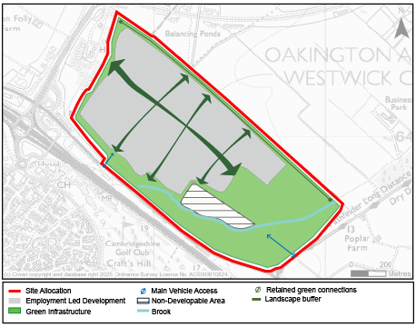
Figure 89: Indicative Spatial Framework for Policy S/SHF: Land north of A1307, Bar Hill (Slate Hall Farm).
Supporting information
3.5.2. This site is allocated for employment uses to meet the demand for local warehousing and logistics, advanced manufacturing and general industrial employment floorspace identified in the studies informing the draft Local Plan.
3.5.3. The policy enables a range of small and medium-scale commercial uses to come forward and it will be important that there is sufficient variety in their form and floorplate size and flexibility in their design to ensure that they cater for a range of different business types and can be adapted over time to meet changing local business needs. As the focus of the site should be on meeting the identified local needs, the site should deliver a range of small and medium sized units. Small and medium sized units are defined as less than 9,300 square metres (100,000 square feet). Development should come forward in phases which respond to local needs.
3.5.4. Given the scale and nature of the proposed uses, the policy identifies a positive approach to landscape mitigation, seeking to create an exemplar proposal that is set within a mature landscape. This is to support the health and well-being of those working and visiting the site but also mitigate landscape and long distance view impacts, existing ecological habitats and species and identified flood risk areas.
3.5.5. The required mitigation measures also include further Archaeological Assessment, which is required given the archaeological potential in this area. Development is also contingent upon the provision of safe and adequate vehicular access to the public highway, the provision of active travel connections to nearby settlements and maximising opportunities to facilitate sustainable last mile deliveries, given the site's, location close to Cambridge and several nearby towns and villages.
3.5.6. The south eastern part of the contains the corridor of the Oakington Brook. This provides a flood risk constraint but also an opportunity to manage water effectively and mitigate flood risk downstream. The area is also important for biodiversity mitigation. Development should therefore be restricted to the north western parts of the site.
3.5.7. Monitoring will ensure full accountability and if necessary further mitigation, or refocussed mitigation which may be needed to ensure that overall compliance with the trip budget is achieved. The full detail of these mechanisms will be established in the S106 obligations entered into on the grant of outline consent.
Tell us what you think
For further guidance on how to submit comments, please see the Representation Guidance Note.
All comments must be received by 25 September 2026 at 5pm.