Policy S/CBN: Cambourne North
1. An expansion of Cambourne for approximately 13,000 homes delivered from 2034, subject to the necessary water infrastructure being available, 108,000 square metres gross internal area (GIA) of employment floorspace, with a range of supporting services and facilities including retail, community, cultural, faith, leisure, education and sports and open space uses. The built area of the expansion will be contained within the Site Allocation boundary identified on the Policies Map.
2. A site wide masterplan will be prepared by the landowners / promoters in conjunction with the Council and in consultation with the local community and other stakeholders, including the East-West Rail Company. The Masterplan should be broadly aligned with the indicative Spatial Framework Plan shown at Figure 66 and will need to identify the broad distribution of land uses, infrastructure delivery and phasing and will be used as a basis for the consideration of subsequent planning applications. The Masterplan should be agreed by the Council prior to the approval of any planning applications (and may be subsequently updated by the landowners / promoters and agreed by the Council).
3. Given the scale and long-term construction of the development, a site-wide place book shall be prepared to establish the vision, place-making objectives and quality expectations for the new settlement and provide the foundation for the site wide Masterplan and Design Codes. The Design Code will ensure that each phase of development positively contributes towards the high-quality placemaking outcomes expected.
4. Cambourne North will be planned comprehensively with the Cambourne North Strategic Enhancement Area (S/SEA/CBN) Policy Area. This area will ensure that there is sufficient physical and visual separation between the development and neighbouring settlements and maintains a soft, green landscape to enhance the wider rural setting and relevant Conservation Areas. Where appropriate the SEA could also deliver other appropriate associated uses including drainage, habitat compensation and public open space.
Objectives and place identity
5. Cambourne North will become an integrated part of Cambourne, a well-connected, sustainable, thriving and prosperous town that is rooted in nature. It will be a fantastic place to live, work or visit, where everyone within the town will have easy access to a wide range of employment opportunities, services and facilities along with high quality open spaces.
6. Through the new railway station being delivered by the East West Rail project and the Cambourne to Cambridge (CtoC) High quality public transport corridor (HQPT) (including extension), the town of Cambourne will become a highly accessible destination in its own right with facilities and open spaces of sub-regional significance, including cultural hub and performance spaces, new leisure hub and employment opportunities.
7. Station Quarter, the new station interchange, will be a focal point for Cambourne North, providing a range of facilities and acting as a new gateway to the town based around a transport and commercial hub for the area. The station should have a dual role as a transport hub as well as a centre of activity for those living in Cambourne and surrounding communities, providing a well balanced mix of uses to support the diverse needs of local residents, workers and visitors. The Station Quarter will be supported by a network of centres of activity that provide people with easy access by walking and cycling to day to day services and facilities, complemented by public spaces for intergenerational communities to gather and set within a green network of open spaces and natural habitats.
8. Cambourne North will incorporate a series of sustainable neighbourhoods, each of which will have a distinct sense of place and community through innovative urban design. Homes, public and private spaces and local facilities will be designed to foster health and sustainability, accommodating people at all stages of life and with diverse needs. The town will benefit from well-considered and distinctive design, which through the design of the buildings and public spaces, will create high quality and lasting places that are memorable and outstanding across all aspects of placemaking.
9. Cambourne North will be a destination for new jobs through the creation of a new multi-sector employment cluster, along with mixed-use centres, providing a wide range of employment opportunities, with a particular focus on jobs that are complementary to those in the wider region, such as mid-tech industries.
10. Critical to the overall success of the town will be the integration of Cambourne North with the existing town and High Street, addressing potential barriers to movement, including the A428 and East West Rail corridor, though a comprehensive movement network for walking and cycling, including a series of new connections and improvements to the public realm. These will deliver seamless, legible and safe movement of people across the wider town and, together with emerging sustainable transport connections and mobility hubs, will support a wider reduction in reliance on private vehicles for local and sub-regional journeys. Additionally, through effective land use planning, the development will maximise trip internalisation. The emerging transport schemes and improvements to walking and cycling networks should also be designed to benefit the existing town.
11. Cambourne North contains and is close to a number of nationally significant ecological and historic assets, including Ancient Woodlands, County Wildlife Sites, and an extensive network of archaeological remains and features. The future masterplan and land use pattern of the town will need to give due consideration to these assets, identifying and implementing measures that mitigate any impacts but also deliver enhancement wherever possible, including creating an extensive network of multi-functional green infrastructure corridors that respond appropriately to their respective ecological and landscape sensitivities.
Uses
12. The site is allocated for mixed-use development comprising:
a. Approximately 13,000 homes (to deliver 2,550 homes by 2045 subject to the necessary water infrastructure being available) comprising of a range of housing sizes, types, and tenures based on identified existing and future local needs, including affordable housing and homes to accommodate people at all stages of life to achieve a balanced and inclusive community, including:
i. 10% of the homes as specialist accommodation (within use classes C2 or C3), particularly for older people or those with disabilities; and
ii. A total of 24 permanent Gypsy and Traveller pitches (within two sites of 12 pitches, each on approximately 1 hectare of land) located within but on the edge of the development, or outside but in close proximity to the site, meeting requirements of Policy H/GT.
b. Employment provision of a range of types and mix to meet the needs of the town and provide access to local jobs and support the continued development of the economy of the Greater Cambridge area;
c. Community services and facilities and infrastructure provision, including:
i. Health hub based on the engagement with local and regional health stakeholders; and
ii. Cultural facilities reflecting current and future local and sub-regional needs;
iii. Dedicated faith spaces to meet the diverse needs of the community;
iv. Local spaces available for small scale independent retail and/or community uses;
v. Education facilities to meet the needs of the development including early years, primary schools, secondary schools, sixth form and for special educational needs;
vi. Open space, sports and leisure facilities, including a new regionally significant leisure, recreation and events centre and associated playing fields; and
vii. Sewage treatment facilities to serve the needs of the development, including upgrading existing local facilities where required.
13. To inform the overarching approach to land use, the applicant must prepare a Social Value and Employment Strategy(ies) that include:
a. Housing in conjunction with key stakeholders, detailing how the site will provide diverse housing types and tenures to meet the needs of the community at all stages of life, including how residential buildings will be designed and delivered to allow for flexibility in response to the changing needs of residents;
b. Place Activation, Culture and Events detailing the range of community, faith, cultural and other related uses to be accommodated in the design of public buildings and spaces. This must be prepared in conjunction with key stakeholders and set out a Stewardship Delivery Plan for long term operation and maintenance of these spaces;
c. Employment to identify appropriate quantum, location, types and mix of employment uses. The strategy will seek to foster the economic prosperity of the town whilst optimising land use, minimizing vehicular trips generated by employment uses and ensuring flexibility in employment space provision. It should also explore the co-location / stacking of employment uses with other uses through mixed use buildings and innovative building typologies. This will be prepared in conjunction with the Local Authority’s economic development team and subsequently reviewed at each phase of the development;
d. Identify and deliver any improvements to existing infrastructure required by the development and which will be relied upon by the expansion of Cambourne; and
e. A key component of the expansion of the town is the Cambourne North Strategic Enhancement Area (S/SEA/CBN) Policy Area. This area will ensure that there is sufficient physical and visual separation between Cambourne North and neighbouring settlements including Knapwell, Elsworth and Papworth Everard and maintains a soft, green landscape to enhance the wider rural setting. The SEA should also support the long-term viability and nature friendly farming principles of RSPB Hope Farm as well as delivering other appropriate associated uses including drainage, habitat compensation and public open space and sports facilities as part of a mosaic of landscapes typologies and uses. Where appropriate, the SEA may also include new and/or improved active travel and highways connections. All uses and facilities within the SEA must be sensitively designed into the landscape context and ensure that ecological species, habitats and (dark) corridors are at the forefront of design considerations.
The development of Cambourne North must do the following:
Context
14. Embed exemplar principles of landscape, townscape and heritage protection and enhancement into all phases of masterplanning and design by:
a. Establishing a strong and robust landscape framework that integrates the development with the Cambourne North Strategic Enhancement Area (S/SEA/CBN) Policy Area and the wider landscape context, informed through preparation of a comprehensive Landscape Strategy;
b. Creating a well-considered landscape buffer within the Strategic Enhancement Area which responds sensitively to the neighbouring villages and their Conservation Areas and delivers wider landscape, ecological and biodiversity mitigation and enhancement measures. The landscape buffer will provide a mosaic of uses and habitats that will:
i. Include the ‘Cambourne Forest’, a new, accessible, regionally significant woodland (aligned to the District Natural Greenspace category in the Natural England Green Infrastructure Framework);
ii. Include areas of open agricultural fields, providing an appropriate context for the conservation areas to the north of the site and supporting farmland birds and other important species and habitats in this area, whilst avoiding the coalescence of Cambourne with Papworth Everard, Elsworth, Knapwell, Bourn Airfield New Village and Childerley; and
iii. Require early, strategic consideration of local ecology through the design stages (aligned to the Local Nature Recovery Strategy) that will help to ensure biodiversity net gain can be fully met on site.
c. Undertaking a Historic Landscape Characterisation and Archaeological Assessment as well as more detailed Landscape Visual Impact Assessment and Heritage Impact Assessments to understand the impacts of development on landscape character, long range and local views and heritage assets and their setting, identifying appropriate mitigation and enhancement measures. These assessments must inform a masterplan process that:
i. Protect and, where possible, enhance the Grade II Listed New Inn Farmhouse and its barns on the southern edge of the Site, any non-designated heritage assets and areas of non-designated archaeology that may be of national significance;
ii. Incorporate areas of open, pastoral structured spaces close to Elsworth and Papworth Everard to preserve their historic rural setting and sense of separation from other settlements;
iii. Provide a broad, well vegetated landscape buffer within the Strategic Enhancement Area, including naturalistic planting and tree lines that respond to topography, historic landscape characterisation and archaeological constraints; and
iv. Retain and enhance the landscape setting of the site, through a masterplan-led approach.
d. Undertaking both desk-based assessment and appropriate field evaluation of archaeological investigation, identifying appropriate mitigation in collaboration where significant remains are found; and
e. Ensuring that major infrastructure proposals are well integrated into the wider landscape and townscape, with nature-based solutions implemented wherever possible.
15. Make provision for and not preclude the delivery of East West Rail and associated rail infrastructure and an extension of the Cambourne to Cambridge public transport corridor from existing Cambourne to Papworth Everard via Cambourne railway station.
Built Form
16. Deliver a new Station Quarter and Town Centre, anchored by a new railway station and multi modal transport interchange, that will become the heart of the town extension. The design must:
a. Include a landmark railway station, based on high-quality placemaking principles outlined in the indicative Spatial Framework, Rail Integration Study and Station Enhancement Study, forming a key component of the Station Quarter, Cambourne North and the overall town and serving the needs of the wider area;
b. Developers will be required to pay a financial contribution to the delivery of an enhanced EWR Station to support the new station interchange that will be a focal point for Cambourne North, providing a range of facilities and acting as a new gateway to the town and strategic Cambourne expansion. This will include a direct link under the proposed station for both active travel and public transport and will be secured through a future Community Infrastructure Levy (CIL) tariff;
c. Avoid overprovision/inflexibility of space that would precipitate empty plots/units. Large retail floorplate buildings will not be supported where they create large inactive frontages and/or would result in the over dominance of a town, local or neighbourhood centre or the town overall; and
d. Create active frontages through choice and positioning of uses, including small flexible units on the ground floor that are suitable for a range of uses to respond to market demand. These should be fine grain, wrapping and capping larger units with other uses and integrating a diverse range of occupiers.
17. Deliver a compact form of development, providing a mix of densities as appropriate to the area of the site, including:
a. Focusing high-density development (circa. 90 dwellings per hectare) at the Station Quarter and Town Centre quarter as well as at neighbourhood centres;
b. Higher densities in employment locations that are within walking and cycling distance of the new station;
c. Promoting efficient use of land and higher density development for all employment sectors, including shared parking and servicing arrangements as much as possible and stacking of employment servicing and logistics infrastructure; and
d. At residential neighbourhoods, incorporating human-scaled and contextually-led development.
18. Provide for a variety of building forms, scales, heights, massing and roofscapes, informed by Landscape Visual Impact, Heritage Impact and Historic Landscape Characterisation Assessments to ensure buildings are appropriately located, designed and mitigation measures are identified and implemented where required.
19. At residential neighbourhoods, ensure the design:
a. Provides a coherent built form, with consistent building lines, street frontages, and a scale that reinforces the character; and
b. Incorporates complementary employment uses as appropriate, including co-working and spaces for self-employed people and small businesses.
20. At employment-led areas, ensure the design:
a. Provides a flexible range of mixed-use and employment spaces which respond to current and future employment needs as well as their immediate context: high street mix, strategic road network access, noise sensitivity and intensification of uses around the station; and
b. Provides active frontages to the public realm at buildings and main entrances, which make a positive contribution to the street scene and wider placemaking objectives.
21. Incorporate well-considered approaches into the design of the town, that are sensitive to local townscape, landscape, strategic views and heritage assets and integrates well with the wider landscape character.
22. Across the site, embed necessary mitigation with regard to noise, light and odour, including from the A428, the proposed railway including the Station as well as recreational activities, to ensure no significant adverse impact on quality of life / amenity and health.
Public space
23. Deliver a new Town Centre and Station Quarter incorporating an associated multi-modal mobility hub, a public square, new green streets, community spaces and a cultural hub, which complement the existing Cambourne Town Centre. Consistent with the principles set out in the Council’s Spatial Framework Strategy, this should:
a. Create a non-linear, appropriately sized, centre to act as a focus for retail, community and civic uses for the town. This should be segmented into multiple blocks to allow for further expansion;
b. Include a flexible cultural hub to anchor activity in the centre; the hub should include space to celebrate the archaeological assets of Cambourne and the wider area; and
c. Be anchored by the Station Quarter Square and a smaller public space with a more civic character. The Station Quarter square should be capable of supporting a regular market including the provision of the necessary market facilities for stall holders and visitors.
24. Deliver a network of clearly defined neighbourhood centres, each including a public play area and/or green space, and additionally providing for a range of co-located uses such as education provision, community spaces and/or facilities including faith spaces, food stores to meet day to day needs, cafés or public houses.
Nature
25. Protect, retain and enhance the statutory (Ancient Woodlands and SSSIs) and non-statutory (County Wildlife Sites) sites, including all designated woodland, and other local sites designated for their value to biodiversity. The development must:
a. Through a Recreational Pressure Assessment, prepared in collaboration with local and national stakeholders, ensure that there is a robust design and management approach to avoid and minimise, as much as is feasibly possible, any adverse impacts on the Ancient Woodlands and SSSIs within or close to the site. This will require on-going monitoring of recreational pressures on these important habitats and species that use them and the implementation of alternative solutions if the initial measures are demonstrated to be ineffective, (e.g. through observed ongoing ecological degradation);
b. Incorporate the following buffer zones to Ancient Woodlands and SSSIs:
i. 40m buffer between Priority Woodland and other designated nature sites; and
ii. 25m buffer to all other green assets within the site; and
c. Identify and deliver measures that minimise ecological pressures to these and other sites from domestic animals.
26. Positively plan for and deliver a network of dark corridors to ensure nocturnal and crepuscular species can forage with minimum disturbance. The development must:
a. Incorporate dark corridors as part of the masterplan for the site, ensuring they are a minimum of 60m in width. The dark corridors must link Knapwell Wood, Elsworth Wood and Papworth Wood as well as form part of a wider dark landscape network beyond the site to Overhall Grove and the Eversden and Wimpole Woods SAC;
b. Where lighting is absolutely necessary, ensure it is sensitive to ecological habitats and species including directional and movement sensitive if appropriate; and
c. Use bat surveys to inform detailed design of the lighting strategy including buffer distances around woodlands.
27. Incorporate planned buffers with diverse species including those traditionally managed through coppice, as well as areas of scrub and natural regeneration. Buffers should be subject to appropriate positive management to maintain biodiversity value and be planted as soon as possible following grant of planning permission, and be subject to appropriate positive management to maintain biodiversity value. Where dark corridors cross necessary transport links, apply the following hierarchy:
a. Areas should be entirely unlit, with connected canopy where appropriate;
b. Where not possible, occasional use of minimal, directional and movement sensitive lighting;
c. A final option where routes require more frequent lighting, rationalised lighting schemes will employ best practice according to bat mitigation guidance.
28. In considering connections between different designated and non-designated sites, prioritise retention of existing habitats and where protected species are shown to be present. Where retention is not possible, replacement habitat networks will need to connect designated sites and areas known to support protected species, such as barbastelle bats and great crested newts. The network – retained and extended – should, be of sufficient quality to enable passage of movement through the landscape unhindered, an important aspect of nature’s recovery and future resilience to climate change. These networks should be subject to appropriate positive management to maintain biodiversity value.
29. Retain and keep dark existing bat habitats including broadleaved woodland, wet pasture and meadows, hedgerows, watercourses and waterbodies. Any replacement habitat intended to provide connectivity should include necessary mitigations to create dark conditions for the movement of Barbastelle bats between old growth woodlands where they may be roosting. Any likely significant losses of, or damage to (including light pollution), habitats and the network should be avoided and considered through appropriate assessment. value.
30. Watercourses should be re-naturalised to enhance for biodiversity and increase potential for reducing flood risk as well as increasing resilience for a changing climate.
31. Provide and retain street trees, woods, hedges, and water features which would contribute to the character and amenity of the town, managed to enhance their ecological value in line with Urban Forestry principles.
32. Create strong active travel connections with new green infrastructure and open spaces to avoid recreational pressures on ancient woodlands and other protected and/or sensitive habitats and species.
33. Integrate blue and green infrastructure into the design of streets, including street trees and watercourses, providing places for people to interact with nature.
34. Consider the multifunctional value of spaces, e.g. amenity, landscape, biodiversity, recreation, flood mitigation and drainage where suitable and practical.
35. Provide sufficient high-quality green infrastructure on site to provide publicly accessible natural and semi-natural open spaces (including within the Strategic Enhancement Area), to compensate for any additional recreation pressure created by the expansion of Cambourne on SSSIs within and adjacent to the site.
36. To inform the overarching approach to ecology and the environment, the applicant must:
a. Carry out a full programme of ecological survey and monitoring, to guide the preparation of a Biodiversity Enhancement, Implementation and Management Plan and Lighting Strategy to provide appropriate mitigation and enhancement. This includes preparing site-specific ecological surveys to inform all phases of development, including strategic masterplanning, development of design detail (including dark corridors and dark buffers) and, where unavoidable impacts occur, appropriate mitigation;
b. Prepare a Biodiversity Enhancement, Implementation and Management Plan in conjunction with key local and statutory stakeholders. It should detail how the expansion of Cambourne and Strategic Enhancement Area will positively contribute to the regional natural environment, including alignment with Local Nature Recovery Strategy ambitions, and ensuring the delivery and stewardship of the ‘Cambourne Forest’ and other associated mitigation and enhancements;
c. The Biodiversity Enhancement, Implementation and Management Plan, alongside the site wide Masterplan, will need to consider all aspects of the SEA area, including appropriate and proportionate visitor facilities and signage; and
d. Adopt a holistic approach to Cambourne’s environmental, economic and social sustainability which provides effective responses to the climate and ecological emergencies. To aid this, the Cambourne North Biodiversity Enhancement, Implementation and Management Plan should be prepared to align with the Cambourne North Climate and Sustainability Strategy.
Movement
37. Deliver a comprehensive and transformative movement and connectivity network for the whole town, connecting key locations including the new Station Quarter and Town Centre, neighbourhood centres, Cambourne High Street, other existing local centres and new East West Rail Station. The network design must facilitate a low car living approach, where walking and wheeling are the first choice for most residents, workers and visitors from the outset. This outcome will be delivered by:
a. Ensuring the design of the site:
i. Focuses the movement network on the Station Quarter and Town Centre, ensuring it is highly accessible and permeable by non-private modes and acts as the interchange for walking, cycling, rail and bus, and other forms of Mass Rapid Transit where relevant, connectivity;
ii. Provides a series of well connected ‘walkable neighbourhoods’, each capable of meeting everyday needs, supported by clear and legible routes and effective wayfinding within and between neighbourhoods;
iii. Includes a clear road hierarchy, including primary distributor routes and sustainable movement prioritised secondary streets and local access roads;
iv. Provides appropriate, and justified, parking provision at the new station, with minimised provision across the wider Station Quarter and Town Centre, to support the achievement of the trip budget; and
v. supports low car ownership across the site, including through appropriate parking provision and innovative approaches such as off-plot car barns and shared parking solutions; and
b. Setting aside land for and/or directly delivering at least the following physical transport measures within the site:
i. Enhanced and new walking and cycling links:
- To surrounding villages including through the Cambourne North Strategic Enhancement Area, that are located and designed to: be accessible throughout the day and evening and all year round; and limit recreational pressures on ancient woodlands and other protected and/or sensitive habitats and species including RSPB Hope Farm; and
- Across the East West Rail route (with the reprovision of existing road connections affected by the new railway delivered by East West Rail Co);
ii. The new high quality and appropriately facilitated East West Rail Station with suitable access arrangements by all modes, in particular active travel and public transport, facilitated by a multi-modal mobility hub and high-quality active travel infrastructure connecting the station to centres, neighbourhoods and surrounding settlements;
iii. Public transport corridors that provide connectivity across the development to Cambourne railway station and towards Papworth Everard and existing Cambourne, integrating with the Cambourne to Cambridge High quality public transport corridor (HQPT);
iv. A primary bus loop providing connectivity across the development and connecting to existing Cambourne;
v. Localised logistics and micro-consolidation hubs; and
vi. Vehicular access into the site via at least the A1198 and A428, including the provision of new or upgraded junctions where required.
c. Directly delivering, or where this is not possible, making financial contributions towards and, as appropriate, enabling the following transport measures external to the site:
i. In early phases of the development, new and enhanced north-south connections which stitch existing and expanded Cambourne together to create one cohesive place, including a landmark ‘landbridge’ connecting Cambourne’s existing High Street, Cambourne Business Park and Bourn Airfield with the new Station Quarter and Town Centre and key services and facilities;
ii. High-quality and safe active travel connections to surrounding villages;
iii. A new public transport and active travel bridge to the west of the A428 dumbbell roundabout to link with the emerging Cambourne West development;
iv. Pedestrian and cycle improvements at two existing junctions on the A428 (at Cambourne and Caxton Gibbet) and the Broadway overbridge; and
v. Strategic active travel improvements, including direct delivery of elements of, or contributions towards, the Comberton Greenway project and other projects where required; and
d. Public transport measures:
i. Extension of the Cambourne to Cambridge (CtoC) public transport corridor into the site and beyond to Papworth Everard, including mobility hub(s) provision to create high-quality bus stopping and passenger waiting facilities, to support the early phases of development. This must be in place to support first occupation of the site, unless it can be demonstrated by the applicant through a detailed Transport Strategy and phasing plan (as agreed with the Local Planning Authority and Local Highways Authority and Transport Authority) that, to support first occupation, there is an alternative, temporary means of securing a frequent, reliable, prioritised public transport service providing fast, direct connections between homes and jobs within Cambourne North, Cambourne, Cambridge and key nearby mobility hubs. If a temporary approach is agreed, the agreed phasing plan must demonstrate an appropriate trigger for completion of the segregated link based on the development capacity supported by that temporary approach; and
ii. To coincide with the opening of the station and support commercial and employment developments, improved local bus connections, including between Cambourne North and nearby villages as well as other settlements and key employment areas where required.
e. Highway improvements and mitigation:
i. Additional enhancements to the ‘dumbbell roundabout’ A428 junction to coincide with and supplement measures implemented as part of the East West Rail project;
ii. Capacity enhancements at the junctions and on local roads where demonstrated through transport modelling;
iii. Traffic calming measures in surrounding villages relating to both highways mitigation and addressing safety issues generated or exasperated by the development; and
iv. Additional strategic highways mitigation measures that may be required beyond the Plan period. The need for these will need to be kept under review including via engagement with National Highways and the Local Highways Authority, including during the lifetime of the development of the site and informed by up-to-date transport modelling.
38. The agreed masterplan and Transport Strategy for the site must demonstrate how:
a. The distribution and mix of development achieves optimal transport outcomes, including high levels of site and city trip internalisation and high active and public transport mode shares; and
b. The quantum and mix of development can be delivered within the agreed trip budget. A definitive trip budget based on detailed evidence must be agreed with the Local Highways Authority prior to submission of the outline application. A monitor and manage approach will be taken to ensure that the development remains within the agreed trip budget for the site throughout its delivery.
39. To support delivery of the agreed masterplan, a strategic and local transport mitigation plan, supported by other studies as necessary, must be prepared by the developer in collaboration with local transport partners, East West Rail Company and National Highways, for agreement with the Local Highways Authority and Local Planning Authority. This must ensure a coordinated and holistic approach between the East West Rail project, Cambourne North proposals the Cambourne to Cambridge public transport corridor (including extension), and wider public transport provision, and must include:
a. Active and public transport measures;
b. Vehicular transport measures, including site access arrangements, and traffic calming measures informed by a Traffic Calming Study developed in conjunction with local communities;
c. A comprehensive parking strategy aligned with low-car living objectives;
d. Infrastructure costing and delivery phasing, demonstrating how the necessary transport measures identified above will be delivered at a time that enables optimal transport outcomes and remains within the agreed trip budget; and
e. mechanisms for delivery, monitoring and review including potential direct delivery by the developer, or where this is not appropriate, through Section 106 obligations, or CIL or other appropriate funding mechanisms.
Resources
40. To positively address known surface water flooding:
a. A site-specific Flood Risk Assessment, including hydraulic modelling of ordinary watercourses within the site, must be undertaken to inform site layout and design levels;
b. A comprehensive water management approach needs to be taken through a Sustainable Drainage Masterplan. This must reduce the existing rate of rainwater run-off whilst delivering benefits for biodiversity, water quality and amenity. Where necessary, financial contributions will be required to deliver off-site mitigation measures; and
c. Where reasonable, contribute to wider flood and water management benefits across the sub-catchment.
41. Prepare a Cambourne North Climate and Sustainability Strategy to inform the masterplan for the site, including detail of how the expansion of Cambourne will minimise on resource use and support net zero targets and climate resilience through the design and delivery of development.
42. Provide appropriate provision for and design of foul drainage and sewage disposal in line with the Cambourne North Climate and Sustainability Strategy and a Foul Drainage Strategy, to be prepared by the applicant.
43. Provide appropriate provision for and design of waste and recycling management facilities, to be in line with the Climate and Sustainability Innovation Delivery Plan and a Street Space and Kerbside Strategy to be prepared by the applicant.
44. Conditions are likely to be necessary to limit first occupations of new dwellings taking place until after the Grafham Transfer water supply intervention becomes operational or where alternative headroom is secured, in consultation with Cambridge Water and the Environment Agency, where the LPA is satisfied that there is scope for earlier development.
Lifespan
45. The approach to the long-term management, maintenance and stewardship of the expansion of Cambourne, including its infrastructure, services and facilities and the Strategic Enhancement Area, must be identified at the outset. An approach that enables community-led stewardship of Cambourne's new place assets should be strongly considered, reflecting the approach to management in the existing town and building on Cambourne's distinctive community spirit and collaborative culture. The stewardship approach must include the approach to funding and financing the management and maintenance of community assets and open space.
46. A Meanwhile Strategy (as part of the Social and Employment Strategies) must be prepared by the applicant to identify opportunities for the meanwhile use of sites for housing, employment and other uses, making efficient use of land while it is awaiting longer-term development.
47. As part of the Social Value Strategy, an Engagement Strategy must be prepared to meaningfully enable local people and stakeholders on site wide and phase/neighbourhood specific proposals.
48. In addition to the requirements on the Validation Checklist, the following will be required at the submission of an outline or major planning application:
a. Place Book;
b. Masterplan;
c. Design Code;
d. Social Value and Employment Strategy(ies) (including Meanwhile Strategy and Engagement Strategy);
e. Stewardship Delivery Plan;
f. Landscape Strategy;
g. Historic Landscape Characterisation and Archaeological Assessment;
h. Social Value and Employment Strategy(ies) (including Meanwhile Strategy and Engagement Strategy);
i. Heritage Impact Assessment;
j. Recreational Pressure Assessment;
k. Biodiversity Enhancement, Implementation and Management Plan, including ecological surveys to determine whether the site is used by Bewick’s swan or whooper swan linked to the Ouse Washes SPA and Ramsar site;
l. Lighting Strategy;
m. Stewardship Delivery Plan;
n. Cambourne North Climate and Sustainability Delivery Strategy;
o. Transport Strategy;
p. Strategic and Local Transport Mitigation Plan;
q. Construction Management Plan;
r. Site-specific Flood Risk Assessment;
s. Sustainable Drainage Masterplan; and
t. Foul Drainage Strategy.
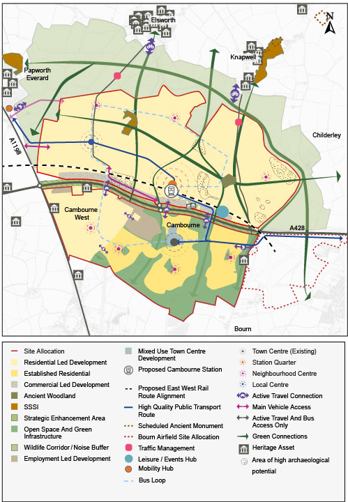
Figure 66: Indicative Spatial Framework for Policy S/CBN: Cambourne North and Policy S/CB: Cambourne.
Supporting information
3.3.3. Cambourne has been identified as the location for a new East West Rail station, providing high speed local and regional connections during the Plan period. This new transport infrastructure presents a significant opportunity to expand the town further, in a way that is both sensitive to local landscape character and ecological sites but at the same time, also supports the existing town so that it becomes more sustainable and can offer the services and facilities required of a modern town.
3.3.4. Underpinning the future development will be a place book. It will establish a shared vision for future Cambourne and articulate the place-making principles, outcomes and quality expectations that will guide its planning, design and delivery. It will set out the characteristics, ambitions and defining qualities that are intended to shape the new settlement, whilst demonstrating how key themes such as movement, green and blue infrastructure, land use, community infrastructure, health and wellbeing, climate resilience, governance and stewardship should work together to create a sustainable, distinctive and well-connected place.
3.3.5. The place book will provide the foundation for subsequent spatial planning and design work, informing the preparation of a site wide masterplan, together with parameter plans, a strategic design code, place briefs and detailed design codes. These documents will translate the vision, principles and outcomes established through the place book into a coherent spatial structure and development framework capable of phased implementation whilst maintaining a consistent and high-quality sense of place throughout the lifetime of the development.
3.3.6. This expanded town will have nature at its core, strengthening local ecosystems, creating a healthy, resilient and intergenerational community. New regionally-significant green spaces will promote well-being and active lifestyles, while a low-emission environment will support health and sustainability, making it a resilient and desirable town and a beacon of contemporary living.
3.3.7. Through this expansion of the town, Cambourne will become a destination location, providing a wide range of services and facilities that support local residents, employees and visitors. This includes a new Station Quarter, the new heart of the development which will be focused around the railway station, offering a mix of homes, employment opportunities and town centre, cultural and community uses. Given the proposed improvements in transport connectivity, there is significant potential for employment growth at Cambourne. The policy identifies a number of required characteristics of employment uses to support the successful generation of greater economic activity and support the wider objective of ensuring that Cambourne is more than just a dormitory town. The Councils would broadly support more employment floorspace than what is set out in the policy provided it would positively contribute to placemaking objectives and can be delivered within the trip budget for the site.
3.3.8. The new East West Rail station and busway provide excellent opportunities to enable a greater density of development in this location. Greater density generates the critical mass of people to support services and facilities whilst also reduces sprawl. The appropriate densities across the site would need to be determined at the application stage following further testing however densities of 60-70 dph or higher could be achieved in and around the Town Centre and Station Quarter. Development, movement connections and public spaces around the new railway station will be optimised where they are well integrated with the station. It will therefore be important that the station design supports this optimisation through its layout and design, including future proofing new and/or enhanced connections under or over the railway as Cambourne North is delivered. The location of the Station Quarter will ensure the expansion area is well integrated with the existing settlement whilst also protecting the vitality of existing services and facilities in surrounding villages.
3.3.9. Experience of development in existing Cambourne, Northstowe and other new settlements has shown that increased diversity of uses and flexibility in space use in the Town Centre and other centres of activity is necessary to ensure that they can become vibrant and activated places. The policy therefore identifies a number of elements that are required for Cambourne’s new Town Centre to avoid overprovision, maintain flexibility and support place activation, which will need to be delivered alongside new homes and employment floorspace. The policy sets out a number of requirements to ensure that the development is well supported by new and enhanced facilities and open spaces from the initial phases of development and that these should complement rather than compete with the existing Cambourne High Street.
3.3.10. In addition to the policy requirements, the Greater Cambridge Infrastructure Delivery Plan (IDP) (2026) has identified that the site, in combination with Cambourne, will require: Upgrade to increase capacity at Uttons Drove WRC , two new primary schools with integrated nurseries; one 8FE secondary school, a on-site healthcare facility, approximately 983 square metres community space, 342 square metres library space to be delivered as a hub library; provision of 206 square metres of swimming pools, a sports hall (four badminton court sizes), and a range of outdoor sports pitches to support the delivery of the site during the plan period and beyond. The exact quantum and phasing of infrastructure will need to be kept under review as the development comes forward, including phases beyond the plan period. This should be informed by on-going engagement with statutory bodies and undertakers.
3.3.11. Walking, cycling and public transport will be the primary mode of travel within and into the town, and transport measures will be need to be planned as a key structural element of the design and layout of the development from the beginning. In particular, an extension to the Cambourne to Cambridge public transport corridor will connect the development with Cambourne High Street, Bourn Airfield and Cambridge as well as Papworth Everard to the northwest, whilst active travel connections over the A428 will enable safe and seamless connections to both sides of the town. There are also opportunities to safeguard the existing Public Rights of Way and enhance them where necessary. Active travel connections should be accessible for all users and provision should also be made in appropriate locations for equestrians, providing links to the existing active travel network beyond the site.
3.3.12. As a result, the policy makes provision for high quality public transport and active travel infrastructure to connect neighbourhoods, surrounding villages, facilities, centres and the railway station and that these interventions must be aligned to the phasing of development. It also identifies the need for new and enhanced crossings across the A428 and East West Rail, enabling residents in existing Cambourne to access new services and facilities by sustainable modes.
3.3.13. High levels of sustainable mode share (percentage of trips using walking/cycling/wheeling/public transport) and trip internalisation (percentage of journeys that are within Cambourne) must be achieved to ensure that growth at Cambourne does not cause major negative impacts on roads and junctions in the surrounding area (both strategic and local roads through existing settlement), both in terms of congestion and highways safety. The policy identifies an overall set of transport principles as well as high level mitigation measures required to support the growth anticipated during the plan period. This includes ensuring there are multiple routes in and out of the development (by all modes) and that the design of the development and the approach to land use planning are critical considerations to reducing private vehicle usage and maximising interalisation.
3.3.14. The precise form, location and scale of interventions will be confirmed through subsequent stages of design and modelling at the planning application stage. These interventions will need to respond to:
- Evolving design development and refinement of the on-site land uses;
- Outcomes of detailed transport modelling and assessment;
- Stakeholder input, including local authorities and infrastructure providers; and
- The phasing of development to ensure appropriate provision is in place as demand arises.
3.3.15. Development at Cambourne North will be subject to a vehicular trip budget to ensure that development does not result in unmanageable congestion on the surrounding road network. The initial trip budget is c.4,000 vehicular trips in the AM peak and c4,000 trips in the PM peak. Monitoring will ensure full accountability and if necessary further mitigation, or refocused mitigation which may be needed to ensure that overall compliance with the trip budget is achieved. The full detail of these mechanisms will be established in the s.106 obligations entered into on the grant of outline consent and CIL contributions at point of commencement of development.
3.3.16. Within the site, New Inn Farmhouse and Barns to the north of New Inn Farmhouse are Grade II listed assets. A masterplan led approach should seek to protect the setting of these assets through an appropriate buffer area.
3.3.17. There are however likely substantial archaeological impacts within the site and therefore archaeological investigation and mitigation will be required. In addition, Childerley Hall has a large deserted medieval settlement to the south of the Hall which is currently undesignated but clearly of equivalent significance to scheduled monuments and so should be considered accordingly.
3.3.18. The Cambourne North Strategic Enhancement Area (S/CBN/SEA) Policy Area is a specific policy designation which serves several purposes. Whilst this will need to refined further and agreed through the planning application process, there is a opportunity to create a regionally significant mosaic of climate resilient and multi-functional landscape typologies, including woodland, arable farming, publicly accessible open spaces and appropriate sports provision. Amenity spaces, including natural and semi-natural green spaces, will also need to be provided for the residents of Cambourne (informed by Suitable Alternative Natural Greenspace principles) as well as those from further afield given the sub-regional importance of the town and SEA.
3.3.19. Green and blue infrastructure has a role in providing amenity, connectivity and recreational value. The policy identifies opportunities to create and connect blue and green infrastructure through a new regionally significant district-scale wooded landscape (Cambourne Forest) and through a series of green and blue linkages throughout the development. Avoidance measures, such as managing access points, the alignment of public footpaths and using natural barriers, will also need to be considered through the design of the Strategic Enhancement Area to minimise impacts on sensitive sites such as Papworth Wood SSSI and well as sufficient ecology and ecology mitigation areas provided.
3.3.20. There a number of ecological designations within and adjacent to the site, including Knapwell Wood, Overhall Grove and Elsworth Wood Ancient Woodlands. These sites must be carefully managed to avoid further deterioration of these irreplaceable habitats, and measures including avoidance zones will be required in line with the NPPF. This will need to be addressed through a comprehensive approach, looking at ecology, landscape, green and blue infrastructure in the round. Additionally, a Recreational Pressure Assessment should be prepared, in collaboration with key local and national stakeholders, to appropriately manage and monitor impacts on ecologically sensitive sites within and adjacent to the development to ensure effective mitigation measures are in place.
3.3.21. The site also contains three sites of special scientific interest (SSSI), and a county wildlife site (CWS) designated for the ancient semi-natural woodland habitat and associated vascular plants they support. All the SSSIs are in unfavourable condition, two of them declining. Retention, protection and enhancement of these sites is key to ensuring the preservation of their value to biodiversity. Eversden and Wimpole Woods SAC, designated for a maternity roost of barbastelle bat (Barbastella barbastellus) which forage over a large area of up to 20 km of connected, suitable habitats such as unlit woodland edge, hedgerows, streams and rivers, is in close proximity.
3.3.22. Any functionally linked land should be retained as a priority and kept dark, as much as practically possible. Any replacement habitat intended to provide connectivity should include necessary mitigations to create dark conditions for the movement of Barbastelle bats between old growth woodlands. The policy provides specific buffer/mitigation distances that should be applied to all designated sites, woodland and other existing vegetation/habitat assets, whilst any connecting habitats intended as part of the foraging network for barbastelle bats should be dark. These areas should be re-naturalised and enhanced for the target species. Detailed surveys are required to inform enhancement and management planning and lighting strategies. The expansion of Cambourne should therefore be shaped by protection of key ecological areas, retaining and enhancing existing links and increasing strategic links between ecological sites.
3.3.23. In addition to the Cambourne Forest, the Strategic Enhancement Area will also need to include other forms of mitigation measures, including arable fields, in particular around the existing northern villages which form part of the setting of the conservation areas, as well as around RSPB Hope Farm. In these areas, priority should be given to the protection of Turtle Doves which are a Priority Species given their decline and the provision of habitats for pollinators. The Biodiversity Enhancement, Implementation and Management Plan will therefore need to contain a wide range of ecological and landscape types and measures to create a rich and diverse ecosystem whilst also set out measures how developers will work proactively with adjacent farmers and other landowners. It will also need to provide suitable flood risk measures, such as water storage or nature based solutions.
3.3.24. The Habitats Regulations Assessment identified that this site may be functionally linked habitat to the Ouse Washes SPA and Ramsar site for Bewick’s swan or whooper swan and ecological survey will be required to assess habitat suitability for these species. If the site is of moderate or high suitability, over wintering bird surveys will be required to confirm whether the site is likely to be functionally linked to the SPA/Ramsar site. Surveys should be undertaken to identify the species present, the numbers of birds involved and the type of use the birds make of the site e.g. roosting, loafing or feeding. Mitigation would depend on the species and habitats present but should either retain/enhance existing habitats; or create compensatory habitats to perform the same function as the affected habitat, and for the same species and numbers of birds. Measures could be delivered on or off site, depending on the land available, and would need to be maintained in perpetuity and monitored to ensure ongoing management remains appropriate. Mitigation needs to be in place and effective before harm resulting from the development occurs.
3.3.25. There is a low density of designated heritage assets north of the A428 in the development area. Main concentrations of assets are at Elsworth, Knapwell, and Childerley Park. Childerley Park is east beyond the Site. Elsworth and Knapwell will be well buffered by existing and enhanced green/landscape features as will Papworth Everard to the west, as indicated on the indicative Spatial Framework. Given the topography of the site and the landscape character, the Cambourne North Strategic Enhancement Area (SEA) Policy Area has been established to provide a landscape buffer will be provided around the eastern, northern and western edges of the site to ensure that development responds sensitively to the neighbouring villages, their heritage assets including the Conservation Areas and their setting, and wider landscape.
3.3.26. In addition to providing landscape, biodiversity and amenity value, the forest could also create benefits in respect of carbon trading and research, which should also be explored. The forest should be a visitor destination, and work to develop the attractors for this will be required, for example it could include an adventure playground. Following the Lawton principles of ‘more, bigger, better and joined up’ this will prioritise protected sites, priority habitats and features that support protected and notable species, and make substantiative contribution to delivering the local nature recovery network.
3.3.27. Through future Local Plan reviews, additional planning designations may be applied to areas within the Strategic Enhancement Area (such as Protected Open Space) as and when they are delivered.
3.3.28. Cambourne’s expansion should minimise its impacts on energy, waste and water networks through a range of the identified sustainability measures and that they must be considered and coordinated at the earliest stages of preparing a development proposal to ensure and holistic, rather than piecemeal, approach is taken.
3.3.29. Development will need a carefully developed approach to planning, delivery and stewardship to ensure that the aims of the policy can be delivered. The policy requires a number of strategies to be prepared in support of planning applications to address these key issues. These strategies should be agreed with the LPA and informed by stakeholder collaboration.
3.3.30. The Grafham Water Transfer is anticipated to be operational from 2032, supplying additional water to Greater Cambridge and easing resource pressures. The housing trajectory accompanying the plan anticipates housing completions from 2034.
Tell us what you think
For further guidance on how to submit comments, please see the Representation Guidance Note.
All comments must be received by 25 September 2026 at 5pm.