Policy S/NST: Northstowe New Town
1. The new town of Northstowe will be a community of approximately 10,180 homes, supported by a range of employment, retail, and community uses, served by the busway connecting Northstowe with Huntingdon, St Ives and Cambridge.
2. Development will be coordinated through a site wide masterplan, prepared by the landowners / promoters in conjunction with the Council and in consultation with the local community and other stakeholders. The Masterplan should be broadly aligned with the indicative Spatial Framework Plan shown at Figure 70 and will need to identify the broad distribution of land uses, infrastructure delivery and phasing and will be used as a basis for the consideration of subsequent planning applications. The masterplan should be agreed by the Council prior to the approval of any planning applications (and may be subsequently updated by the landowners / promoters and agreed by the Local Planning Authorities).
Objectives and place identity
3. Northstowe will be a sustainable and vibrant new community that is inclusive and diverse with its own distinctive local identity which is founded on best practice urban design principles, drawing on the traditions of fen-edge market towns, which encourages the high quality traditions and innovation that are characteristic of Greater Cambridge.
4. Through its ongoing development, the site will continue to embody long-established character and design principles for the new town, including ensuring it is well integrated into the surrounding landscape; delivering a distinctive town character with well-designed and landscaped neighbourhoods; incorporating exemplar, low carbon design, able to accommodate the impacts of climate change; and securing a balanced, viable and social inclusive community.
5. In addition to continuing the delivery of homes across the site, a key priority for future phases of development will be the delivery of key community facilities, amenities and services to improve the vibrancy and sustainability of the place. Among these will be a town centre supported by smaller local centres including commercial and retail uses, employment uses and sports hub, sports pitches, mixed use zones, a water park, open space and green corridors, incorporating active travel routes and associated infrastructure works.
Uses
6. The new town of Northstowe is allocated for mixed-use development, comprising:
a. Approximately 10,180 homes (delivering 6,201 homes within the plan period) in a wide range of dwelling types and tenures including:
i. Affordable housing;
ii. 24 permanent Gypsy and Traveller pitches (within two sites of 12 pitches, each on approximately 1 hectare of land) located within but on the edge of the development, or outside but in close proximity to the site, meeting requirements of Policy H/GT;
iii. Community led homes and self/custom build homes; and
iv. Approximately 850 units of specialist accommodation (Use Class C2 and C3), particularly for older people or those with disabilities;
b. Employment floorspace, to be provided in accordance with agreed Town Centre Strategy or an up-to-date Employment Study, including offices, research and development, light industrial (Classes E(g)(i), E(g)(ii), E(g)(iii)) and storage and distribution (B8). This must be:
i. Focused on the new town centre, enterprise zone and local centres throughout all phases; and
ii. Delivered at phased timescales, providing space to facilitate home working and flexibility for start-ups and for businesses to grow;
c. Retail and other Town Centre and Local Centre uses, to be provided in accordance with an up-to-date Retail Needs Assessment and/or agreed Town Centre Strategy;
d. Social and leisure facilities to meet the needs of the development, including a community centre and youth facilities;
e. Education facilities to meet the needs of the development, including a additional primary schools;
f. Recreational spaces to meet the needs of the development, including allotments, woodland and community orchards/gardens;
g. Cultural facilities, to meet the needs of the development, including faith spaces, libraries, burial land and public art;
h. Healthcare facilities to meet the needs of the development;
i. Green infrastructure, including for biodiversity and sustainable drainage features;
j. Public access to established landscaped water park and footpaths for recreational purposes and leisure purposes; and
k. Indoor and outdoor sports facilities, to meet the needs of the development, which are to be quantified and phased in accordance with an agreed Sports Strategy, play spaces and sports pavilions.
7. Temporary community and healthcare facilities may be required until sufficient capacity has been reached for permanent provision. The size and nature of these facilities will need to be considered throughout the build period of the development, ensuring that such buildings have sufficient flexibility to be able to expand or be repurposed as each phase of the development comes forward.
8. Northstowe New Town will be planned comprehensively with the Northstowe Strategic Enhancement Area (S/SEA/NST) Policy Area. This area will ensure that there is sufficient physical and visual separation between Northstowe and neighbouring settlements and maintains a soft, green landscape to enhance the wider rural setting and relevant Conservation Areas. Where appropriate the SEA could also deliver other appropriate associated uses including drainage, habitat compensation and public open space.
The development of Northstowe must do the following:
Context
9. Ensure the built area of the settlement is contained within the Site Allocation boundary identified on the policies map and as shown on the indicative Spatial Framework diagram.
10. Ensure separation from surrounding villages is maintained to avoid the merging of Northstowe with surrounding communities and maintain key views to surrounding landmarks, including:
a. Retaining areas of countryside within the Longstanton Conservation Area, forming an effective green separation. These areas must only contain open land uses such as playing fields, allotments and cemeteries;
b. Providing a green separation on the northern side of Oakington, including additional tree planting of individual trees, groups and copses to reinforce the pastoral parkland nature of this local landscape area. Tree groups must be located so as to obscure views through the green separation but at the same time retain a more open character;
c. Achieve an appropriate relationship with the existing settlement of Rampton Drift through the layout of the development, appropriate land uses and building typoplogies in this location; and
d. Maintaining the open aspect of the fields affording views of Grade I All Saints Church and Grade II* listed St Michaels Church and St Andrews Church.
11. Maintain and enhance key landscape features, including:
a. The adjoining Local Nature Reserve of St Michael’s Mount, Longstanton;
b. Longstanton Paddocks;
c. Rampton Drift , which must be sensitively integrated through a variety of appropriate landscape treatments, including additional planting to supplement the existing nearby mature trees; and
d. Existing on site trees, making the best use of these as a setting for the development.
12. Incorporate strategic landscaping within the Site Allocation boundary, around the boundary of the settlement including within the Strategic Enhancement Area. This should draw on the Fen-edge landscape of the site and the adjacent heritage assets and their setting.
13. Through a design led approach and preparation of a Conservation Management Plan, protect and enhance the setting of the Grade II listed pillboxes within the site, the Longstanton, Oakington and Westwick Conservation Areas and their associated heritage assets.
Built form
14. Deliver a new Town Centre, to be located at the heart of Northstowe in accordance with agreed Town Centre Strategy. This must:
a. Make provision for a mix of uses, including shops, services, cultural, leisure and community facilities, as well as employment and residential uses at first floor level or above, to serve the needs of Northstowe and the wider surrounding area.
15. Incorporate local centres within close proximity to residents, grouped with other uses and facilities, such as a primary school and/or bus service, and include a focal point for legibility;
16. Provide a mix of densities as appropriate to the area of the site, including:
a. Higher densities and heights in the Town Centre and around local centres; and
b. The lowest heights and densities towards the edges of the settlement.
17. Where there is public access to land adjoining Longstanton and Oakington, mitigation measures must be provided to protect the privacy and amenity of potentially affected properties.
Public space
18. Incorporate landscape areas and green corridors to contribute to the informal recreation needs of those living, working and visiting the town, including for informal children’s play.
19. Deliver a town park adjoining the Town Centre, and appropriate ancillary facilities.
Nature
20. Create a network of green spaces within the settlement, which integrate well with the development and contribute to the legibility and attractiveness of the place. This must:
a. Ensure a high degree of connectivity between green areas, within the town for wildlife and people;
b. Include the creation of a parkland landscape between Northstowe and Oakington to provide a substantial resource of trees, grassland and other areas of semi-natural vegetation, designed and managed for its wildlife value;
c. Retain and enhance the tree belt along the airfield road between Longstanton and Oakington, with additional planting to provide a strategic landscape boundary to the new town;
d. Retain, as biodiversity features, existing tree plantations and Military lake in the southern section of the airfield and the existing ponds in the golf course;
e. Include appropriate planting and landscaping alongside all new access roads and the parallel distributor roads alongside the A14 as well as substantial planted areas in association with balancing ponds;
f. Promote awareness within the local population of biodiversity within and beyond the town and thus encourage its protection and enhancement; and
g. Be developed in accordance with an approved Landscape Strategy for the settlement;
21. Wherever practical, incorporate water features in the form of lakes and watercourses as one of the defining characteristics of Northstowe, including a surface water drainage network to offer recreational opportunities.
22. To assist the creation of a mature landscape at an early stage in the development, existing landscape features must be retained where they make a significant contribution to the urban environment and/or strategic landscaping. This should be carried out at the early stages of development and accordance with an approved Landscape Strategy.
Movement
23. Deliver a comprehensive and legible movement and connectivity network for the new town, connecting key locations of activity. The network design must facilitate a low car living approach, where walking, wheeling and public transport are the first choice for most residents, workers and visitors from the outset, supported by residential, school and workplace travel planning.
24. This outcome will be delivered by:
a. Ensuring the design of the site:
i. Focuses the movement network on the key areas of activity within the town, ensuring they are highly accessible and permeable by non-private modes;
ii. Provides a series of well connected ‘walkable neighbourhoods’, each capable of meeting everyday needs, supported by clear, safe, convenient and legible routes and effective wayfinding within and between neighbourhoods;
iii. Includes a clear road hierarchy, including primary routes, secondary streets and local access roads, which prioritise sustainable movement; and
iv. Promotes low car ownership.
b. Setting aside land for and/or directly delivering at least the following physical transport measures within the site.
25. Provision of a dedicated bus only route through the town and connected to the existing Cambridgeshire Guided Busway (CGB) ensuring that stops are conveniently located to ensure all homes are within easy walking distance of a bus stop, whilst not compromising the level of service provision.
26. Provide a highly accessible network of safe and convenient cycleways, segregated from other modes where appropriate, and to ensure covered, secure cycle parking facilities for homes, workplaces, the town centre, local centres and other places.
27. Commensurate with the phasing of development, making financial contributions towards and, as appropriate, enabling the following transport measures:
a. Developing an improved rights of way network to support sustainable transport, recreation and health, and to connect the town to neighbouring villages and the open countryside, including for walking, cycling and horse riding;
b. Providing an initial subsidy for new residents to encourage bus usage. The subsidy will fund free or discounted travel by public transport;
c. Setting up a car sharing scheme including the associated parking provisions, which shall be in accordance with an approved scheme; and
d. Demonstrating that there is sufficient highway capacity available in the A14 corridor between Bar Hill and Cambridge for the traffic forecast to be generated by each phase of development, and ultimately for the total homes proposed and approved in outline planning permissions.
28. To support delivery of the agreed masterplan, a strategic and local transport mitigation plan must be prepared by the developer in consultation with the Local Highways Authority and Local Planning Authority. This must include making financial contributions towards and, as appropriate, enabling any other transport measures necessary to make the development of the site acceptable in transport terms, as evidenced at planning application stage;
a. Sustainable and public transport measures;
b. Vehicular transport measures, including site access arrangements;
c. A comprehensive parking strategy aligned with low-car living objectives;
d. Infrastructure costing and delivery phasing; and
e. Mechanisms for delivery, monitoring and review including potential delivery through Section 106 obligations, or CIL or other appropriate funding mechanisms.
Resources
29. Ensure that landforms and engineering works as part of any drainage scheme do not compromise the Fen-edge character of the surrounding area, by considering the landscape options available for the site.
30. Provide, manage and ensure the ongoing maintenance of sustainable surface water drainage measures to control the risk of flooding on site and off site, in perpetuity.
31. Make appropriate arrangements for foul drainage and sewage disposal, to be explored and identified through a Foul Drainage Strategy;
32. Make provision for recycling existing building materials by the granting of planning permission for a plant to process such materials into hardcore and aggregates, which would be located towards the eastern edge of the Oakington Airfield.
33. Development must be supported by comprehensive strategies including:
a. For the management and maintenance of all water bodies and watercourses; and
b. Construction, to be agreed, to avoid construction vehicles travelling through nearby villages or having an adverse effect on biodiversity.
Lifespan
34. Throughout its development, Northstowe must be comprehensively masterplanned and delivered to ensure that development proposals do not prejudice the creation of a fully functioning and successful new town.
35. In addition to the requirements on the Validation Checklist, the following will be required at the submission of an outline or major planning application:
a. Approved phasing plans, parameter plans and site wide strategies;
b. Design codes, prepared for all phases to guide subsequent reserved matters applications;
c. An Employment Study;
d. A Retail Needs Assessment and/or Town Centre Strategy;
e. A Sports Strategy;
f. A Landscape Strategy;
g. Strategic and Local Transport Mitigation Plan;
h. A Transport Assessment;
i. Management and Maintenance Strategy relating to Landscaping and open spaces, biodiversity, community buildings, indoor and outdoor sports facilities; and unadopted roads and parking enforcement; and
j. Foul Drainage Strategy;
36. Ecological surveys to determine whether the site is used by Bewick’s swan or whooper swan linked to the Ouse Washes SPA and Ramsar site.The applicant must identify a proposed approach to the long-term management, maintenance and stewardship of any infrastructure, services and facilities not provided by statutory undertakers.
37. At all phases of development, applicants must consider and propose appropriate measures to assist the development of a new community, for example the funding and recruitment of community development workers.
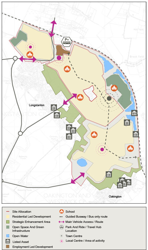
Figure 70: Indicative Spatial Framework for Policy S/NST: Northstowe New Town.
Supporting information
3.3.66. Since the initial allocation of the site as a new town, six outline planning permissions have been granted that together cover the allocated site and reserved land. In addition to this, several detailed permissions have been approved, and some construction of the development has been carried out. The site is anticipated to be developed beyond the Plan period. The Council maintains high aspirations for the new town, ensuring that it delivers exceptional standards of sustainability, high quality design and a strong sense of community.
3.3.67. The new town is located very close to Longstanton and Oakington and strong landscape buffers, within the Northstowe Strategic Enhancement Area (S/SEA/NST) Policy Area, are required to retain separation between the settlements. This is also necessary to protect the historic landscape character of the Conservation Area at St Michael’s including the Local Nature Reserve and the important early ridge and furrow field system. Important views across the fields to other heritage assets should also be retained to protect their settings.
3.3.68. The existing community of Rampton Drift will be incorporated within Northstowe and this needs to be carried out sensitively to protect the amenities of existing residents.
3.3.69. A range of facilities will be necessary to serve residents and provide a comprehensively planned new town. The proposed town centre will be a vibrant and diverse centre of activity in the heart of Northstowe, where it will be accessible by walking, cycling and public transport. It should include shops, services, cultural, leisure and community facilities and residential units at first floor level and above. A community centre in Phase 1 has now been built, and the continued phasing of facilities is required to serve residents as the town grows.
3.3.70. Local centres will have only modest shopping facilities and services and may include play areas and small-scale office/employment uses appropriate to a residential area. They should be phased to provide day-to-day facilities for residents as the town is developed and located in accordance with the agreed Development Framework Document and as refined by subsequent outline permissions.
3.3.71. A secondary school and primary school have now been built but further education facilities will be required to meet the needs of the new town, including additional primary schools, agreed through engagement with the education authority.
3.3.72. Employment areas should be located close to the town centre and local centres where they are easily accessible by walking, cycling and public transport.
3.3.73. Building heights will need to respond to the town’s setting and land use activity, in particular lower heights at the settlement edge to reduce the impact on the surrounding area whilst higher densities towards the centre will support a lively town centre with a critical mass of people to support the services and facilities within it.
3.3.74. There should be a high degree of connectivity between green areas within the town for wildlife and people, for play on the way, and to provide connection with the wider countryside. Water, in the form of lakes and watercourses will be part of the defining characteristics of Northstowe. This reflects the Fen edge location of the site and mitigates existing flooding. A parkland landscape between the new town and Oakington will provide wildlife value, public amenity as well as separation between settlements.
3.3.75. Northstowe is close to the Bar Hill junction with the A14 and traffic forecasting at each phase is needed to monitor and manage the impact of the development on that road and junction. Access to the public transport corridor providing rapid public transport between St Ives and Cambridge has been provided in Northstowe, in the interests of sustainable development and to mitigate traffic impacts on the existing road network. A dedicated public transport corridor is intended to run through Northstowe providing a public transport service for residents to key areas within the town, including the town centre, to reduce trips by private car.
3.3.76. A water park has been provided as a strategic engineering element associated with flood attenuation of the wider site, as well as for nature and amenity. Flood risk and surface water flooding will need to be considered with future development in accordance with a site wide strategy.
3.3.77. The Habitats Regulations Assessment identified that this site may be functionally linked habitat to the Ouse Washes SPA and Ramsar site for Bewick’s swan or whooper swan and ecological survey will be required to assess habitat suitability for these species. If the site is of moderate or high suitability, over wintering bird surveys will be required to confirm whether the site is likely to be functionally linked to the SPA/Ramsar site. Surveys should be undertaken to identify the species present, the numbers of birds involved and the type of use the birds make of the site e.g. roosting, loafing or feeding. Mitigation would depend on the species and habitats present but should either retain/enhance existing habitats; or create compensatory habitats to perform the same function as the affected habitat, and for the same species and numbers of birds. Measures could be delivered on or off site, depending on the land available, and would need to be maintained in perpetuity and monitored to ensure ongoing management remains appropriate. Mitigation needs to be in place and effective before harm resulting from the development occurs.
3.3.78. For the new town to be successful long term, provisions for the management and maintenance of infrastructure, services and facilities are necessary and are to be agreed with the Local Planning Authority.
3.3.79. A Development Framework Document was agreed in 2012 which forms a site wide masterplan and is a material consideration in determining planning applications.
Tell us what you think
For further guidance on how to submit comments, please see the Representation Guidance Note.
All comments must be received by 25 September 2026 at 5pm.