What this policy does
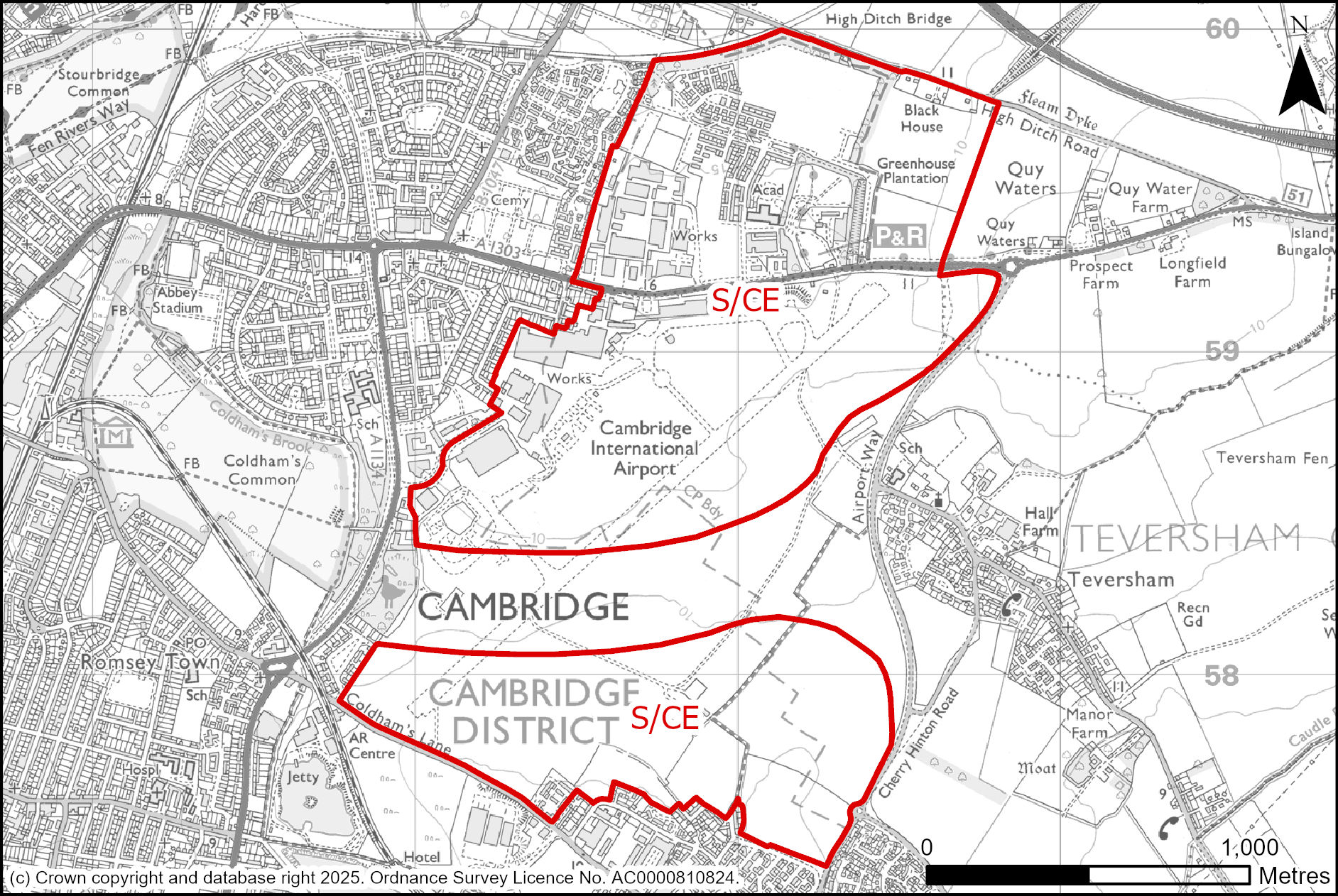
Land was released from the and safeguarded in previous plans for the development of a major new urban extension at Cambridge East. The policy plans for the comprehensive development of the whole area which is now anticipated to become available for development, including land at Marleigh and Springstead Village, where delivery has not been constrained by the operational airport.
Policy S/CE: Cambridge East
Vision and identity
1. Cambridge East will be a vibrant, inclusive new city district that reflects the spirit of Cambridge while shaping its future. Rooted in a unique setting, Cambridge East will offer welcoming, walkable neighbourhoods which support an intergenerational community to live well, work purposefully, learn, and thrive.
2. A vibrant urban quarter will form the heart of this well-connected mixed-use district, bringing together cultural and commercial space, including research and development, to foster economic opportunity, collaboration, and innovation. Green streets, public spaces, and a new Cambridge Common will connect communities, promote wellbeing, and support nature recovery. Excellent sustainable transport links will ensure seamless access to the city and beyond.
3. Guided by design excellence, environmental responsibility, and long-term stewardship, Cambridge East will set new standards for sustainable, high-quality placemaking.
Uses
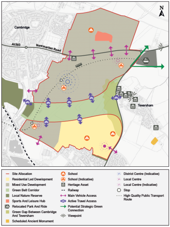
4. Cambridge East is allocated for mixed-use development as shown on the Policies Map and indicative Spatial Framework comprising:
a. Approximately 8,000 dwellings of a range of sizes, types and tenures to meet the identified diverse housing needs and to support a mixed and balanced intergenerational community, specifically including:
i. a total of 24 permanent Gypsy and Traveller pitches (within two sites of 12 pitches, each on approximately 1 hectare of land); and
ii. 10% of the approximately 8,000 dwellings as specialist accommodation (within use classes C2 or C3), particularly for older people or those with disabilities.
b. A range of supporting services and facilities to meet the day-to-day needs of those living, working, visiting, travelling through and attending education there, including education, health, community and retail uses. These uses will be delivered at a series of walkable and wheelable neighbourhood centres;
c. Provision for such a wider range and scale of cultural, leisure, education, shops, community and faith facilities as will meet the needs of Cambridge East and the immediately surrounding area, as well as those of the wider city and sub-region, that will complement and not compete with Cambridge city centre, which may include civic uses, a conference centre, concert hall, arts centre or leisure facilities;
d. Significant employment floorspace in use classes E(g), including offices and research and development focused upon the district centre, as well as a minimum of 20,000m2 (gross internal area) B2/B8 employment floorspace with good access to the road network to provide for mid-tech and general industrial uses.
The development of Cambridge East must do the following:
Context
5. Establish a strong landscape framework to integrate built development into the site and integrate the district with the surrounding urban and landscape context;
6. Create a well-considered eastern approach to Cambridge that:
a. is sensitive to local townscape, landscape, strategic views, dynamic views and heritage assets, including the rural setting of the Teversham
and the wider countryside to the east; and
b. integrates well with established and new neighbouring communities, including Marleigh and Springstead Village.
7. Celebrate heritage assets, including the terminal building, boundary walls and Hangar 1, as key buildings in the new city district, establishing a positive strategy for the conservation and enjoyment of the historic environment which:
a. responds positively to heritage character;
b. creates a well-composed setting and landscape around heritage assets;
c. manages building scale sensitively; and
d. delivers viable and sustainable uses consistent with their conservation.
Built form
8. Adopt a distinctive and contemporary approach to urban design which:
a. promotes the highest standards of sustainability and liveability;
b. reflects Cambridge’s identity by respecting the city’s design traditions while embracing modernity; and
c. embraces innovative approaches to foster an inclusive, vibrant and diverse community of all ages, creating a strong sense of place and belonging.
9. Through the masterplan for the site, agree an appropriate scale, layout and density of development that:
a. supports liveability, in a compact, walkable and sustainable urban form, maximising the opportunity provided by the site;
b. provides appropriate connections between neighbourhoods, public spaces, cultural and educational facilities, promoting active travel and public transport use;
c. creates and, where appropriate, reinforces local character and architectural quality, providing smooth, well-designed transitions in scale to respect and complement the surrounding context.
10. Through the masterplan for the site, agree appropriate variation in building form, scale, height, massing, and density to shape a distinctive city district by:
a. providing taller buildings in appropriate locations to mark key spaces, enhance wayfinding and complement the Cambridge skyline;
b. utilising innovative approaches to development typologies to define character area; and
c. responding to key views and approaches to the site.
11. Use the highest quality materials and detailing to ensure durability, environmental performance and design excellence, supporting climate resilience.
Public space
12. Deliver an eastwards extension to Coldham’s Common using the
corridor, which must:
a. be multifunctional and vary in form and character along its length
b. ensure that active travel and recreational uses are sensitively designed to maintain a semi-rural landscape with a mosaic of habitats, including neutral grassland, native scrub, hedgerows, woodland, and wetland, in the tradition of the Cambridge Commons;
c. open to a greater width at the Teversham end, maintaining a clear gap between Cambridge and Teversham, protecting the village’s identity and character, heritage assets and rural outlook and setting by providing an informal countryside character; and
d. connect to new strategic green infrastructure beyond the site.
Nature
13. Create a strong and varied framework of green infrastructure throughout the development that maximises optimises biodiversity value and connects to existing habitats and green infrastructure in the surrounding area, including:
a. Establishing an integrated framework of open spaces, green corridors, and green infrastructure across the new district, delivering a landscape resilient to climate change. This must:
i. integrate with any required urban drainage measures
ii. embed nature friendly green spaces into development parcels as well as within the green corridor;
iii. appropriately balances ecological enhancements and protection with amenity uses, sports, recreation and play.
b. Enhancing ecological links to existing habitats beyond the site boundary, responding to the strategic priorities for this area of the emerging Local Nature Recovery Strategy; and
c. Providing strategic scale green infrastructure beyond the site that will:
i. Enable a seamless strategic green connection through from Cambridge City Centre to the Wicken Fen Vision area;
ii. Provide facilities for recreational needs of all ages and abilities and accessible green space, taking visitor pressure off more sensitive sites including Wilbraham Fen SSSI.
Movement
14. Ensure an exemplar approach to movement and transport within and through the site, transforming the wider connectivity of the eastern edge of Cambridge and promoting a low car living approach where ‘walking and wheeling’ is the first choice for most residents and visitors from the outset, by:
a. providing a series of well connected ‘walkable neighbourhoods’, each meeting everyday needs, with effective wayfinding within and between neighbourhoods;
b. delivering a high-quality public transport route through the site connecting the relocated Newmarket Road Park and Ride into the city, serving Springstead Village and other mobility hubs within the district and neighbourhood centres;
c. locating all development within easy walking distance of mobility hubs, with significant provision of public transport, walking and wheeling connections throughout the site connecting to wider routes that will enable sustainable journeys to be made between Cambridge East and other key destinations within Cambridge, including:
i. Cambridge Station, City Centre and onwards to West Cambridge and wider destinations on radial public transport corridors; and
ii. Southern loop to serve Cambridge Biomedical Campus, Cambridge South Station and Cambridge Leisure site.
d. providing vehicular access only from Newmarket Road, Airport Way, Coldham’s Lane and Barnwell Road into distinct low traffic neighbourhoods which are:
i. not linked for general traffic;
ii. promote low car ownership by supporting low levels of parking, provided in innovative forms of car storage such as off-plot car barns.
15. The agreed masterplan for the site must demonstrate how:
a. the mix of development achieves optimal transport outcomes, including high levels of site and city trip internalisation and high active and public transport mode shares;
b. The capacity and mix can be delivered within the identified trip budget. The indicative trip budget is approximately 1,500 trips in the AM peak and 1,800 trips in the PM peak. A refined trip budget based on more detailed evidence must be agreed with the Local Highways Authority prior to submission of the outline application. A monitor and manage approach will be taken to ensure that the development remains within the agreed trip budget for the site throughout its delivery.
16. To support delivery of the agreed masterplan, a strategic and local transport mitigation plan must be prepared by the developer in consultation with the Local Highways Authority and Local Planning Authority. This must include:
a. Sustainable transport measures;
b. Indicative costings;
c. Phasing; and
d. Potential delivery via a Section 106 agreement or CIL.
Resources
17. must integrate Sustainable Urban Drainage Systems and flood mitigation measures as both functional and amenity features within the design of landscapes and open spaces, including daylighting culverts where feasible.
Lifespan
18. To support the submission of an outline planning application, the applicant must prepare and submit:
a. Overall masterplan, setting out the final capacity and mix of uses on site and demonstrating how the proposed development meets the requirements set out in this policy;
b. Strategic design code, establishing clear rules and guidelines tailored to the requirements of the site;
c. Parameter plans, to fix key site requirements such as access and movement, land uses, green and blue infrastructure, scale and massing and densities. In part, this should be informed by a Landscape Visual Impact Appraisal and
;
d. A strategic and local transport mitigation plan;
e. Other supporting strategies as necessary.
19. Required supporting strategies include but are not limited to:
a. Community development plan;
b.
strategy;
c. Phasing and delivery strategy;
d. Parking strategy; and
e. Stewardship Strategy, which must set out short- and long-term arrangements for the management, maintenance, and governance of public spaces, community assets, and infrastructure. The strategy should be proportionate to the scale and complexity of the new city district and clearly integrated with the overall phasing and delivery strategies and should incorporate processes and structures to ensure the active and informed involvement of residents.
20. The masterplan and strategic design code will be subject to community and other stakeholder engagement and critical review by the Cambridgeshire Quality Panel (or successor body) as part of their development and refinement.
21. Subsequent reserved matters applications for full planning permission will only be determined once the supporting strategies have been approved, and future applications will need to demonstrate compliance with these strategies and the outline approval. More focussed design codes for specific neighbourhoods should be prepared and submitted as part of the reserved matters applications, in line with any relevant conditions in the outline approval.
22. Depending on the development programme, the applicant may develop a reserved matters scheme alongside the outline as a means of testing the emerging parameter plans and design code.
23. Early delivery of infrastructure must be agreed with the Local Planning Authority, including:
a. Key public transport, walking and cycling routes to embed sustainable travel habits;
b. Strategic green infrastructure provision, creating habitats, providing access to green space for new residents and extending the green network available to the city.
Marleigh and Springstead Village
24. The development of Marleigh and Springstead Village must:
a. Ensure development proposals are in accordance with the approved masterplan, design code;
b. Undertake meaningful engagement with local people and stakeholders at the relevant Reserve Matters stages.
25. Marleigh will deliver (and not exceed the specified maximum floorspace) the following development in accordance with outline planning permission (S/2682/13/OL):
a. Up to 1,300 residential dwellings;
b. Primary school (F1), potentially including community hall – 2.3 hectare primary school site;
c. Community hall of 200 square metres gross internal floorspace (excluding any parish office);
d. Foodstore (E) – Up to 1,500 square metres gross internal floorspace;
e. Petrol Filling station;
f. Flexible mixed-use units (E, F1, F2) – Up to 3,000 square metres gross internal floorspace;
g. Park pavilion comprising: café, public wc’s, park store, offices, and gym (E, F2 and sui generis) – 2,600 square metres of which 1,600 square metres offices gross internal floorspace;
h. Sports pavilion (F2) – 200 square metres gross internal floorspace;
i. Allotment clubhouse and amenities (F2) – 200 square metres gross internal floorspace;
j. Replacement car dealerships (sui generis) – up to 4 hectares.
26. Springstead Village will deliver (and not exceed the specified maximum floorspace) the following development in accordance with outline planning permission (S/1231/18/OL and 18/0481/OUT):
a. Up to 1,200 residential dwellings, including up to 90 bed spaces in a retirement living facility;
b. Primary school – 2.3 hectare site;
c. Secondary school – 6.9 hectare site;
d. Flexible mixed-use units – Classes E, F2, sui generis within local centre up to 1,850 square metres gross internal floorspace, including:
i. Food store (E) up to 500 square metres gross internal floorspace;
ii. Community hall (E) up to 250 square metres gross internal floorspace.
Supporting information
This policy is required to enable the continued development of the site as a comprehensive new city district, to ensure the development of the airport site will integrate with Marleigh and Springstead Village, as originally envisaged in the Cambridge East AAP.
The Spatial Framework for Cambridge East sets out an indicative high level illustration of the policy requirements that are location-specific within the site. Noting remaining uncertainties regarding development, in particular that a masterplanning exercise has yet to be completed, the framework is subject to change.
The policy sets out clear expectations for placemaking and the elements needed to deliver an exemplar development. Achieving successful integration of this site within its context will require careful consideration, recognising both the scale of opportunity, but also the need to respond to the existing townscape and landscape, including integrating well with Marleigh and Springstead Village, and being sensitive to retained historic assets on the site, the setting of Teversham , and with the wider townscape and landscape. should be of a density to support liveability while enforcing local character and architectural quality, ensuring taller buildings make a positive contribution to the Cambridge skyline in line with the and Tall Buildings Strategy.
Reflecting and maintaining an important part of Cambridge’s identity the site will ensure an extension of Coldham’s Common eastwards using the corridor. The current boundaries of the corridor are retained for the purposes of the . The current boundaries reflect a uniform width of the corridor of 300 metres over its whole length. When delivered, it is not necessary or expected that the corridor will be of that or any uniform width, indeed that is not considered appropriate for the corridor to take that form.
As envisaged in the Cambridge East Area Action Plan 2008, including the inspector's report, the ultimate boundaries of the in this area are expected to be an output of a masterplanning exercise, which has yet to be completed. As such, the current boundaries of the corridor will remain unchanged but, following completion of the masterplan-planning exercise, precise boundaries to reflect the masterplan will be confirmed via a review of the . In the event that the masterplanning exercise is completed and a planning application for development affecting the green corridor is made before the conclusion of a review of the , any development within the corridor will be determined having regard to extant development plan and policy.
If it is demonstrated via the masterplanning process that locating some development within the retained corridor is necessary to achieve high quality placemaking, this may amount to a consideration that could in principle contribute to a finding of very special circumstances to justify grant of planning permission for that development. In such a case, it will be necessary to show, as part of any planning application, that the function of the corridor is maintained or enhanced. Where the masterplan shows development in the corridor, there may be a requirement for compensatory widening of the corridor elsewhere in order to maintain the function of the corridor. The physical boundaries of the corridor should be considered and determined through the masterplanning exercise.
Cambridge East is an important location for meeting ’s long-term housing needs, including those for specific groups such as older people, those with disabilities and travellers. For employment, the site is well located to be successful as a significant scale new cluster for office and laboratory space in the eastern part of the city, and has a key role to play in meeting ’s significant need for industrial space, being well located to meet demand for mid-tech and general industrial uses.
It is imperative that the mix of development supports an intergenerational community and achieves optimal transport outcomes including high levels of site and city trip internalisation and high active and public transport mode shares. Further exploration of the capacity of the site will be undertaken, including further density and heights testing, before preparing the Proposed Submission , although to achieve additional numbers would require innovative approaches to development typologies.
The policy sets out expectations to enable movement around the new city district and beyond to destinations such as Cambridge city centre, without overburdening the existing network and in a sustainable way. The indicative vehicular ‘trip budget’ set out in the policy is a critical tool for achieving this. The trip budget will be refined as more detailed evidence is completed, and a monitor and manage approach will be taken to ensure that the development remains within the agreed trip budget for the site throughout its delivery.
(EWR) are currently considering the potential inclusion of a new railway station to the east of Cambridge. The Councils are fully supportive of a station in this location, which would provide a step change in public transport connectivity for this site and eastern Cambridge more widely. It would be important to ensure any station is delivered to the highest quality, appropriately integrated within the development, and that sustainable travel connections to and from any station are provided. If a station were to be included in the Consent Order application this would alter the local context; this could therefore result in a change of scale and layout of development at Cambridge East to that outlined above. It is anticipated there will be greater certainty on EWR’s proposals ahead of the Proposed Submission .
The policy requires provision of a country park beyond the site to connect through to the Wicken Fen Vision area. Further engagement with relevant partners is needed to determine the location, scale and character of this space. This proposal will be refined in the Proposed Submission Plan.
The final phase of Marleigh was granted planning permission in July 2025 (23/04930/REM & 23/04936/FUL) taking to overall development to 1,391 dwellings, slightly more than granted in the consented 1,300 in the outline application (S/2682/13/OL). Springstead Village was granted outline planning permission for residential-led development with up to 1,200 dwellings (18/0481/OUT & S/1231/18/OL) in 2020. A reserved matters application for Phase 4 (23/03347/REM) was approved in April 2024. (Note: subsequent to the planning permissions being granted planning use classes have been updated; the updated use classes are referenced in the policy). Construction work has commenced on both sites, and some homes are occupied.
These sites were able to progress as early phases of the full development that could come forward while the airport is still operational. Any future development proposals must be in accordance with the approved masterplan and design code. Proposals at Springstead Village (formerly known as Land North of Cherry Hinton) must also have regard to the Land North of Cherry Hinton Supplementary Planning Document, adopted in December 2018, which is a material planning consideration.
Supporting topic paper and evidence studies
- : Strategy Topic Paper
- : Sites Topic Paper
- Housing and Economic Land Availability Assessment (2025)
- Employment Land Review & Economic Evidence Base (2020)
- (2025)
Tell us what you think
We will consider all comments while developing the next version of the .
All comments must be received by 30 January 2026 at 5pm.