What this policy does
This policy provides a consistent planning framework for managing new applications for development of this new settlement in the context of a new strategic allocation for site. The policy will ensure that new development is well integrated, whilst maintaining a separation from other nearby settlements, serves the needs of existing and future communities and mitigates the impact of development where required. Grange Farm will be developed during the period of the Local Plan and beyond.
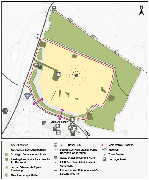
Policy S/GF: Land adjacent to A11 and A1307 at Grange Farm
1. Grange Farm will be a thriving and sustainable new community, providing a distinctive mixed-use development shaped by a comprehensive and innovative approach to delivering resilient placemaking. It will be delivered through a design-led approach with placemaking and nature at the heart of development.
2. Located at the heart of the Rural Southern Cluster, a globally important cluster of science innovation, Grange Farm will play a vital role in locating high quality new homes close to existing employment areas, connected through a holistic active travel and public transport network. At its heart, it will be a vibrant place that provides for the day-to-day health, wellbeing and quality of life needs of new residents, workers, surrounding communities and visitors, by positioning new local centres, schools, community uses, and other local services and amenities close to homes.
3. The new settlement will play a critical role in extending the Cambridge South East Transport scheme, with a new segregated connection proposed which would also enable potential future extension of the proposed scheme to settlements further afield.
4. Development will need to respond to the surrounding character and context whilst maintaining a distinction with other surrounding settlements, in part through the preservation of the existing distinctive built and natural environment.
5. The proposed Grange Farm site sits alongside the S/SEA/GF non-development areas adjacent to Grange Farm Strategic Enhancement Area. The Strategic Enhancement Area aims to ensure sufficient separation from neighbouring settlements and maintain a soft, green landscape to protect the development’s rural setting. These areas may also be used to deliver other associated uses, including drainage, habitat compensation and informal open space.
6. Grange Farm contains and is close to a number of nationally significant ecological and historic assets, including the Worsted Street Roman Road Scheduled Ancient Monument and SSSI to the north, County Wildlife Sites, an extensive network of archaeological remains and features, various listed and non-designated heritage assets as well as the Abington Conservation Area to the south. The future layout of the new settlement will consider these assets, identifying and implementing measures that mitigate any impacts but also deliver enhancement wherever possible, including creating an extensive network of ecological corridors
Uses
7. Development proposals must make a positive and meaningful contribution to the creation of a fully functional, self-contained new settlement. To achieve this, the site is allocated for mixed use development comprising:
f. Approximately 6,000 homes, including:
i. affordable housing, self and custom build homes and key worker housing to support surrounding employment sites;
ii. 10% of the approximately 6,000 dwellings as specialist accommodation (within Classes C2 and C3), particularly for older people or those with disabilities.
g. A total of 12 Gypsy and Traveller pitches (within a site of approximately 1 hectare);
h. Class B2 (General Industrial) floorspace and Class B8 (Storage or
Distribution) through provision of a local last-mile logistics hub/warehousing of approximately 20,000 square metres (GIA);
i. Approximately 15,000 square metres (GIA) office (E(g)(i) floorspace to meet local needs generated by the new settlement;
j. A mix of retail, commercial and community facilities including indoor and outdoor leisure provision, provided at a new town centre;
k. Provision of educational facilities including primary and secondary schools that are operational from the early phases of development;
l. Healthcare facilities to meet the needs of the development; and
m. High quality open space and recreation provision, including parks, community gardens and food-growing spaces.
The development of Land Adjacent to A11 and A1307 at Grange Farm must do the following:
Context
2. Embed exemplar principles of landscape, townscape, heritage protection and enhancement into all phases of masterplanning and design by:
a. Ensuring the development respects, protects and enhances the landscape within its rural setting, including surrounding chalk hills and woodlands;
b. Responding sensitively to the local townscape and heritage, incorporating appropriate buffers where appropriate and necessary, including:
i. the Worsted Street Roman Road Scheduled Ancient Monument to the north;
ii. the Grade II listed Worsted Lodge Farmhouse immediately to the north-west,
iii. onsite burrows;
iv. non-designated heritage assets at Grange Far; and
v. known and unknown archaeological assets.
c. Establishing a robust landscape framework that integrates the development with the Strategic Enhancement Area (S/SEA/GF) and the wider landscape context, informed through preparation of a Landscape Visual Impact assessment;
d. Undertaking Heritage Impact and Historic Landscape Character Assessments to understand the impacts of development on landscape character, long range and local views and heritage assets and their setting, identifying appropriate mitigation measures and informing the appropriate siting and design of buildings; and
e. Maintaining separation between Grange Farm and surrounding existing settlements, including Little Abington and Babraham.
Built form
3. Ensure the built area of the settlement is contained within the Site Allocation boundary identified on the policies map and as shown on the Spatial Framework diagram.
4. Take a design-led approach to development through the preparation of a comprehensive Masterplan for the site and subsequent design codes for each phase of development, in accordance with the Spatial Framework, that demonstrate how the design will:
a. contribute to creating a thriving place, with access to key services and facilities that will support the community and surrounding villages from the outset;
b. respond positively to key landscape, heritage, townscape and ecological features (identified elsewhere in this policy), and how these will be afforded appropriate protection and enhancement;
c. deliver buildings that respond to the surrounding context and ensure heights of taller buildings do not adversely impact sensitive views, heritage assets and the setting or character of surrounding communities, particularly considering scale, density, massing and form at:
i. the northern area of the site, where densities should be limited to reduce impacts on the Worsted Road Roman Road;
ii. the new local centre towards the centre of the site (as shown on the Spatial Framework diagram), where taller buildings may be appropriate.
d. provide for an appropriate variety of typologies, scales, massing and densities across the site;
e. identify landmark features and buildings that aid legibility and create identity within the new development;
f. maintain the distinction between Grange Farm and neighbouring villages, in terms of character and physical separation
g. deliver exemplar design quality, reflecting the site’s prominent location and close association with nearby innovative employment centres.
5. Deliver a network of new centres for the town, specifically:
a. A vibrant Town Centre, approximately in the centre of the site (as shown on the Spatial Framework diagram), which will act as a landmark for community and civic facilities and amenities and be the main focus for commercial and retail uses;
b. Neighbourhood centres, serving day-to-day need for key services, education and community facilities in close proximity to homes.
6. At these centres, buildings and main entrances provide an active frontage to the public realm and make a positive contribution to the street scene and wider placemaking objectives.
7. Deliver an appropriate mix of well-designed, high-quality residential neighbourhoods to meet a range of needs, incorporating:
a. a range of typologies, including terraced houses, semi-detached and mews housing, built at an average density of 50-55 dwellings per hectare (net);
b. homes that are adaptable to support the needs of future generations; and
c. a range of other uses at neighbourhood centres, embedded within neighbourhoods, providing key facilities, services and flexible community amenity uses, (for example a community centre that provides social benefit including sport and recreation), within a short walking or wheeling distance of homes.
Public space
8. Establish a high-quality public realm that encourages healthy lifestyles, physical activity and positively contributes to wellbeing, including through legible and well-lit routes that enable safe walking and wheeling throughout the day and night.
9. Provide open space comprising formal children’s play space, informal children’s play space, informal open space, allotments and community orchards.
10. Integrate green and blue infrastructure into the design of the public realm including by providing places for people to interact, play and rest in nature.
Nature
11. Preserve and enhance significant ecological heritage and the natural environment across the allocation, Strategic Enhancement Area (S/SEA/GF), and its surrounding context, by:
a. Adopting a landscape-led design that supports the diverse ecological character and preserves the chalk hills and woodlands that are home to a species rich ecology;
b. Maximising opportunities for ecological enhancement, such as through restoration of degraded habitats and reinforcements of ecological habitats and networks, including commuting, foraging and sheltering of species such as badgers, bats, hedgehogs and other mammals, birds, amphibians and invertebrates;
c. Appropriately responding to the designated Roman Road Site of Special Scientific Interest (SSSI) and remnant lowland calcareous grassland of high floristic diversity to the northern boundary of the development, and non-statutory designations such as local wildlife sites within 2km distance of the development;
d. Ensuring that appropriate measures are implemented to minimise recreational disturbance and pressures on ecology at the SSSI;
e. Creating dark corridors to ensure nocturnal and crepuscular species are not disturbed, by providing minimal lighting near to the buffer of the development, and directional and movement sensitive lighting where appropriate;
f. Preserving the existing range of watercourses and waterbodies of ecological significance and aquatic ecosystems, including the River Granta, a chalk stream that flows through Little and Great Abington;
g. Creating a clearly defined green buffer between the neighbouring settlements which:
a. preserves viewpoints from the northern and eastern boundary of the site;
b. protects existing landscape features; and
c. extend and strengthens the existing treeline along the edge of the site.
12. To inform the design at all phases of development, the applicant must:
a. carry out a full programme of ecological survey and monitoring, to guide a Biodiversity Implementation and Management Plan, providing appropriate mitigation and enhancement. This must include preparing site-specific ecological surveys to inform all phases of development, including strategic masterplanning, development of design detail (including dark corridors) and, where unavoidable impacts occur, appropriate mitigation;
b. propose measures that will support the appropriate positive management of any ecological buffers, to maintain biodiversity value.
Movement
13. Deliver a comprehensive movement and connectively network across the whole town that actively encourages and prioritises active and sustainable modes of travel, and provides connections across the site and to surrounding villages and employment sites. This must:
a. Deliver a well-connected network that prioritises walking, wheeling, cycling and public transport movements and provides a legible high quality street network in accordance with Healthy Streets guidance and National Design Guidance;
b. Improve walking and cycling infrastructure to Babraham, Babraham Research Campus, the Wellcome Genome Campus, Granta Park, Little and Great Abington, Linton, and Whittlesford Station, including addressing local severance from the A1307 and A11;
c. Ensure there is no direct access from the new settlement to the Worsted Road Roman Road, given archaeological, heritage and ecological sensitivities;
d. Provide a segregated link for the proposed Cambridge South East Transport busway to enable the project to serve the development without being impacted by local congestion; and
e. Explore opportunities for an active travel connection parallel to the segregated link to connect the new settlement with central Cambridge, Babraham, the Cambridge Biomedical Campus and Granta Park.
14. Integrate a last mile logistics hub within development to enable delivery of goods from the distribution centre and supports the trip budget in reducing the number of trips through the development.
15. Ensure transport and junction modelling is be undertaken to confirm points of vehicular access into the site and the necessary road and junction enhancements required to satisfy the Highways Authority and National Highways.
16. A trip budget based on detailed evidence must be agreed with the Local Highways Authority prior to submission of the outline application. A monitor and manage approach will be taken to ensure that the development remains within the agreed trip budget for the site throughout its delivery.
17. To support delivery of the agreed masterplan, a strategic and local transport mitigation plan must be prepared by the developer in consultation with the Local Highways Authority and Local Planning Authority. This must include:
18.
a. providing appropriate access to and from the site to avoid congestion on the A1307 during peak travel hours, with appropriate mitigation methods to the transport network; and
b. Potential delivery of mitigations and other supporting transport schemes through Section 106 contributions.
19. To reduce private vehicle usage from the outset of the development and improve placemaking, prioritise incorporating rural car barns into the design at the edge of parcels or plots to enable remote parking solutions.
Resources
20. As part of the design, consider innovative approaches to incorporating low-carbon energy infrastructure, circular economy principles, and sustainable water management, including greywater recycling, rainwater harvesting, and sustainable drainage systems (SuDS), informed by preparation of an Integrated Water Management plan and Water Cycle Strategy.
21. Demonstrate that development can provide or contribute to suitable wastewater treatment plant on-site, or at a suitable nearby location with sufficient capacity to support development.
Lifespan
22. The delivery of Grange Farm, including any individual phases, must be in accordance with an approved phasing plan that must be submitted alongside the first planning application for the site, to ensure the expansion supports the creation of a fully functioning and successful town.
23. Planning for essential services, facilities and infrastructure must be undertaken in a comprehensive manner at the outset, identifying and anticipating future needs and establishing suitable mechanisms to deliver the infrastructure in a timely and efficient way to achieve the successful delivery of the new settlement.
24. The approach to the long-term management, maintenance and stewardship of the new settlement, including its infrastructure, services, facilities and built and natural environment, must be identified at the outset through a Management and Maintenance Plan that sets out a comprehensive approach to the long-term management of the site as it evolves.
25. In addition to those required in other areas of this policy, the applicant must prepare a range of supporting studies, and submit these for approval by the Local Planning Authority as part of an outline planning application, including:
26. Phasing and delivery plan, including indicative costings and potential delivery through Section 106 agreements or CIL;
27. A Parking strategy;
28. A Meanwhile use strategy;
29. An Integrated water management plan;
30. A Waste management plan;
31. A cohesive stewardship strategy through early-phase community engagement including through conservation groups to deliver community-based enhancement stewardship as endorsed by Natural England;
32. A strategic and local transport mitigation plan (in consultation with the Local Highways Authority and Local Planning Authority); and
33. A Sustainability Statement.
Supporting information
The location of Grange Farm provides an opportunity to create a high quality and sustainable town that is residential-led but provides access to nearby employment centres such as Babraham Research Campus (S/BRC) to the north west, Granta Park to the south, and the Wellcome Genome Campus and Chesterford Research Park to the south west. Development will support these existing employment sites through provision of key worker housing, services and amenity provision and access to high quality green open spaces.
This policy is required to enable comprehensive development of the site, and provide a framework for consideration of future planning applications. The policy sets out clear expectations for placemaking and the elements needed to achieve this to a high standard whilst responding to significant historic landscape and heritage assets including the chalk hills and woodlands that are home to a species rich ecology.
Housing should be of high quality design and be located nearby to centres to enable access to amenities to support the day to day need of residents and visitors. Homes should provide a range of types and tenures and should include delivery of affordable housing, build to rent, and key worker housing.
The Spatial Framework for Grange Farm sets out an indicative high level illustration of the policy requirements that are location-specific within the site.
Currently, the site is bounded by the A11 to the west and the A1307 Cambridge Road to the south, which provides the existing access to the site, with a Roman Road (public right of way) to the northern boundary. To the west is access to the A1307, one of the main routes into the city of Cambridge, and the A11.
Walking, cycling, and public transport will be the primary modes of access, supported by a coherent and legible network of routes within the site. Development should enhance connectivity and integrate proposed the CSET scheme to reduce car dependency.
Implementation of an effective site-wide Travel Plan against the trip budget, that include measures such as site-wide micromobility, car-sharing, electric car clubs, and incentives to encourage travel by active and sustainable modes.
For Grange Farm to be successful in the long term, management and maintenance of infrastructure, services and facilities must be provided and should be agreed with the Local Planning Authority.
Supporting topic paper and evidence studies
Greater Cambridge Local Plan Sites Topic Paper
Tell us what you think
We will consider all comments while developing the next version of the Local Plan.
All comments must be received by 30 January 2026 at 5pm.