What this policy does
This policy sets out a robust planning framework for the continued and comprehensive redevelopment of North East Cambridge. It defines the scale and scope of development of the site to ensure that North East Cambridge meets the vision and objectives that were developed through the North East Cambridge Area Action Plan preparation process.
In August 2025, the Government announced that it will not be funding the relocation of the Cambridge Waste Water Treatment Plant (CWWTP) through the Housing Infrastructure Fund, which means that there is uncertainty as to whether the effective delivery of a significant proportion of the residential component of the Councils’ vision for North East Cambridge will take place in the time period previously envisaged, including the assumed delivery of a significant amount of housing within the plan period. Building on the previously adopted polices for this area, for this draft Local Plan consultation, the Councils are retaining the draft allocation for North East Cambridge incorporating the vision previously set out in the Proposed Submission North East Cambridge Area Action Plan, noting the significant benefits that a comprehensive mixed use development at this site would bring. Delivery of this vision would be subject to alternative funding being found to enable the relocation of the Cambridge Waste Water Treatment Plant.
Ahead of the Local Plan Proposed Submission stage in 2026, the Councils will continue to engage with relevant partners to confirm a refined position for the site, including the scale, type and amount of development proposed and any necessary updates to the spatial framework.
Policy S/NEC: North East Cambridge
Vision and identity
1. North East Cambridge (NEC) will be transformed into a thriving and inclusive new district that builds on the strengths of Cambridge’s existing innovation hubs including Cambridge Science Park, St John’s Innovation Park and Cambridge Business Park, while enabling them to evolve to meet future needs. At its heart will be a vibrant quarter that is walkable and low-carbon, bringing together world-class businesses, high-quality homes, services and cultural amenities, and welcoming public spaces. Designed to embed accessibility and meet every day needs locally, it will provide all that residents need and reach out to integrate and support surrounding neighbourhoods and the wider city.
2. The relocation of the Cambridge Waste Water Treatment Plant (CWWTP) together with enhanced public transport and active travel connections, will unlock the full development potential of North East Cambridge. This will enable intensification of commercial and industrial space alongside the provision of significant new housing and civic spaces. Together these elements will create a diverse mixed-use place rooted in innovation, sustainability and a strong sense of place. The district will be anchored by a new centre at the heart of a vibrant new urban quarter, supported by a network of high-quality public spaces, educational facilities and community infrastructure. North East Cambridge will grow as a district that is socially and economically inclusive and environmentally sustainable.
Uses
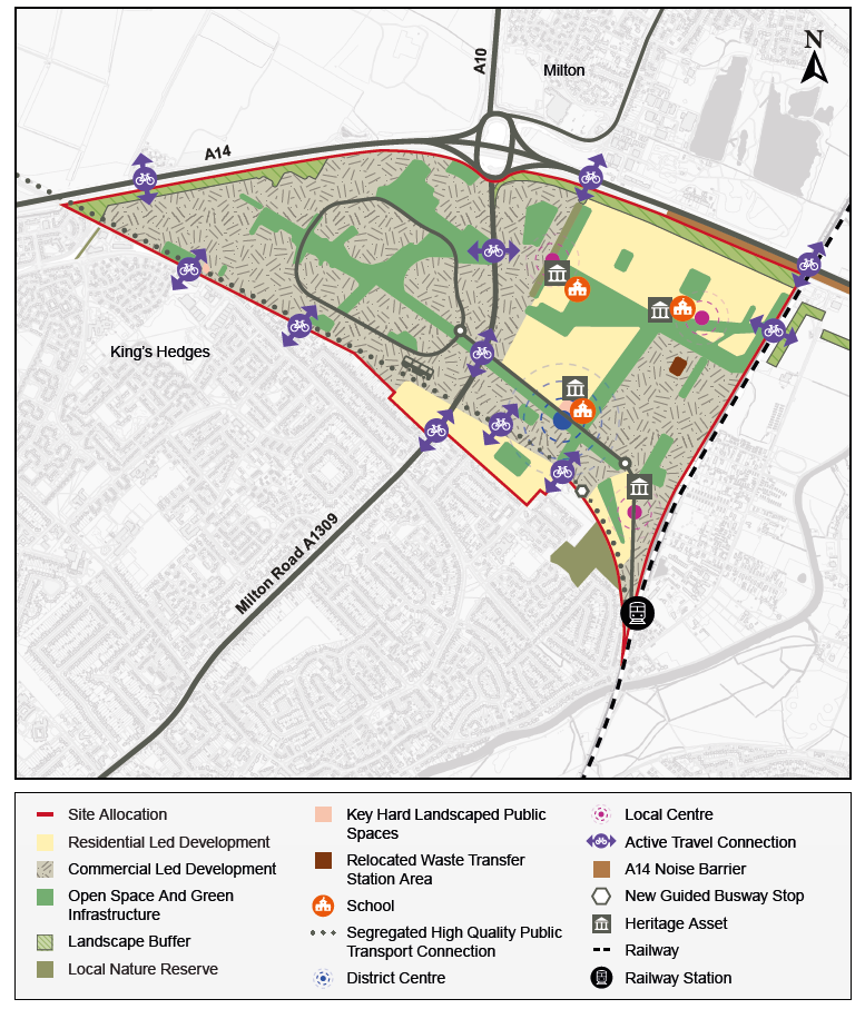
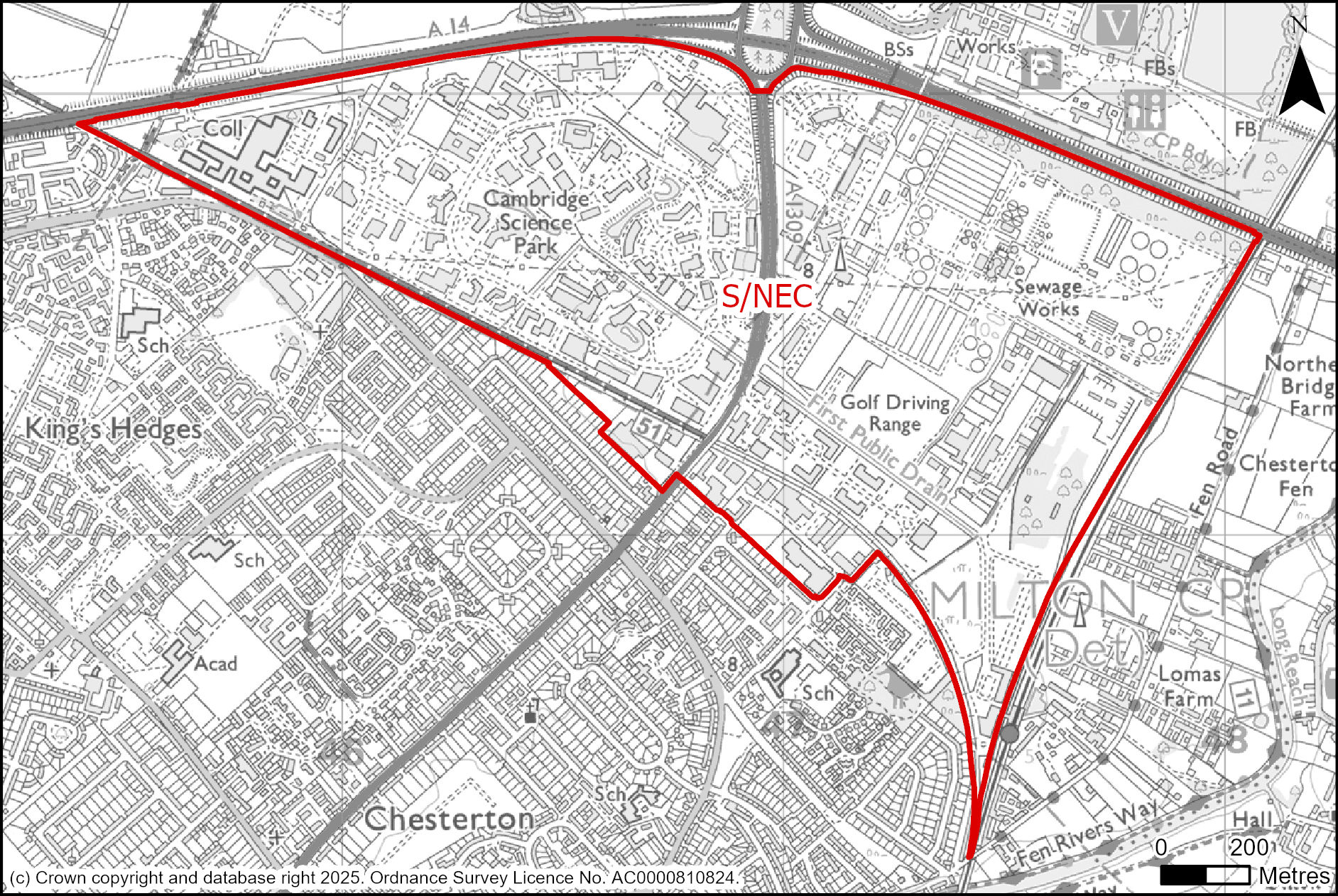
3. The comprehensive regeneration of North East Cambridge will deliver a balanced, vibrant mixed use district across its 182 hectares. The area provides a gateway to the City and is the largest urban regeneration opportunity in Cambridge. It is a significant mixed-use development with capacity for approximately:
a. 8,350 new homes, including around 5,500 homes on the existing CWWTP site;
b. Up to 320,000 square metres (Gross Internal Area) of additional business floorspace (Use Class E(g));
c. Additional 27,300 square metres (Gross Internal Area) of industrial floorspace for mid-tech, light industrial, and creative industries;
d. Safeguarded uses include the Waste Transfer Station, Aggregates Railheads, and Cowley Road Bus Depot, which must be maintained unless relocation is secured; and
e. A new district centre around Cowley Road will provide the social, cultural, and commercial heart of North East Cambridge. It will include retail, community, leisure and cultural uses around active frontages and high-quality public spaces.
4. Minimum on-site provision of community and cultural uses will include:
a. Two primary schools, with land reserved for a third if population triggers are met;
b. Visual and performing arts hub (studios, gallery/museum, theatre/community space);
c. Library and community centre;
d. Health hub;
e. Formal outdoor sports courts and a five-court indoor sports hall; and
f. Community gardens and food-growing spaces.
5. Facilities should be co-located where possible, reducing travel needs, creating lively neighbourhood hubs, and strengthening the sense of community.
The development of North East Cambridge must do the following:
Context
6. North East Cambridge will be a contemporary reinterpretation of Cambridge's urban form, with:
a. A compact, walkable structure based on a fine grain network of streets, blocks and spaces;
b. Identifiable Centres of activity and streets with clear identities that encourage play, and spaces that facilitate and encourage social interaction, play and cultural events;
c. An extensive high-quality network of multifunctional open spaces;
d. Integration with surrounding neighbourhoods including East Chesterton, Milton and King’s Hedges, through active edges, public access and improved east-west connections;
e. Redevelopment of the CWWTP site must consider legacy infrastructure, any operational elements that remain, and potential odour impacts while the treatment works are still in operation;
f. Significant A14 traffic noise requires mitigation, with a noise barrier near the road being the preferred solution;
g. Design must ensure integration with surrounding neighbourhoods, connectivity, and high-quality public realm, so new development feels part of a larger, accessible district.
Built form
7. The built area of the development as shown on the Spatial Framework diagram will provide:
a. Mid- to higher-density development with taller buildings in well-justified locations, primarily around the proposed district centre and fronting Milton Road;
b. well-articulated urban skyline that responds to the setting of the city, key views and integrates varied rooflines and silhouettes;
c. A strong design character that draws on industrial heritage (such as waterworks and sidings) while embracing architectural innovation;
d. Mixed-use development will blend living, working, and leisure to create a dynamic, human-scaled environment;
e. Proposals must avoid closed ‘campus-style’ layouts and promote openness and inclusivity, providing public access to green spaces, roof terraces, cafes, and community facilities;
f. Development should maximise local benefits, including access to jobs, training, and skills opportunities, so the district supports both innovation and social inclusion.
g. The scale of NEC allows for a wide range of housing types and tenures, creating well-balanced, inclusive communities;
h. Housing will be integrated with neighbourhood facilities, streets, and public spaces to encourage walkability, social interaction, and a sense of community;
i. NEC is anchored by Cambridge Science Park, St John’s Innovation Park, and Cambridge Business Park, which drive the local and national innovation economy. Commercial development will be delivered through intensification of existing employment parks and mixed-use development around the district centre and local centres, including land adjacent to Cambridge North Station. This level of development will require enhancements to sustainable travel and adherence to the identified trip budgets;
j. NEC will continue to play an important strategic role in providing industrial functions that support the wider Cambridge economy and contribute to local employment. Existing industrial capacity will be retained and consolidated around Cowley Road Industrial Estate, with additional industrial floorspace for mid-tech, light industrial, and creative industries;
k. Industrial areas will be designed to support economic activity while being visually integrated and accessible, avoiding isolated or closed-off sites; and
l. Clustered local centres will complement the district centre, forming a vibrant urban quarter that supports daily life, promotes walkability, and encourages community interaction.
Public space
8. Street design must reduce reliance on private motor vehicles and support active travel through provision of:
a. Primary streets: Low-speed streets and spaces (design speed of below 20 mph) to prioritise, walking, cycling, and micro-mobility, with segregated facilities where needed and well-integrated public transport measures.
b. Secondary streets: Serve essential/emergency vehicles and off-plot parking; no through traffic; provide filtered permeability and shared space design approaches.
c. Car-free zones: Near hubs and centres; designs must consider kerb space management for deliveries, EVs, and mobility users.
9. An integrated network of parks, squares, play spaces and water features, that seamlessly joins with and is accessible to the strategic networks outside of the North East Cambridge Area, such as to the River Cam and Chesterton Fen;
10. Spaces for community food growing, informal play, and health-focused green spaces within every neighbourhood.
Nature
11. North East Cambridge will deliver an exemplary green and blue infrastructure network that will enable everyone to lead healthy lifestyles, protect and enhance biodiversity, and help mitigate the impact of development on climate change. This is to be achieved through:
a. The provision of an integrated network of parks, squares, play spaces and water features, that seamlessly joins with and is accessible to the strategic networks outside of the North East Cambridge Area, such as to the River Cam and Chesterton Fen;
b. Embedding nature across all development typologies, including green roofs, trees, habitat corridors and urban greening;
c. Meeting 20% Biodiversity Net Gain on-site and the protection/enhancement of hedgerows and water bodies, including the First Public Drain; and
d. The provision of community food growing, informal play and health-focused green spaces within every neighbourhood.
Movement
12. North East Cambridge is planned as a walkable, human-scale, low-car district that supports everyday needs, encourages active travel, and integrates homes, workplaces, and community facilities. The movement strategy is designed to prioritise sustainable travel, reduce reliance on private vehicles, and create streets and public spaces that are safe, accessible, and vibrant.
Active travel and public transport first
13. Development must be designed around active and sustainable travel, enabling safe, accessible, and attractive movement for all users, designed to:
a. Prioritise walkable neighbourhoods, low traffic streets, and excellent public transport connectivity;
b. Support a comprehensive, direct, legible network for walking and cycling, integrated with green space and public realm;
c. Be located within 5 minutes’ walk of high-quality public transport and active travel routes;
d. High-quality mobility hubs must be included at key locations to support seamless interchange between walking, cycling, micro-mobility, and public transport.
Cycle parking and micro-mobility infrastructure
14. Cycle parking must exceed minimum standards and be:
e. Secure, covered, and conveniently located throughout the area;
f. Integrated into mobility hubs, centres, workplaces, and public spaces; and
g. Designed to include:
i. At least 5–10% provision for non-standard cycles;
ii. Electric charging for e-bikes, scooters, and mobility aids;
iii. Shared or flexible facilities with maintenance stations where appropriate.
15. Provision must be justified within Design and Access Statements, Transport Assessments, or Travel Plans.
Wider connectivity requirements
16. Development must contribute to improved off-site capacity and connections for non- motorised users, including:
h. Enhanced links to nearby villages, employment centres, Cambridge city centre, and surrounding countryside; and
i. Upgraded or new crossings of:
i. A14 (Jane Coston Bridge, underpasses, Waterbeach Greenway)
ii. Cambridgeshire Guided Busway (including new access points and activated frontages);
iii. Railway (new pedestrian/cycle bridge to Chesterton Fen);
iv. Milton Road (underpasses or bridges connecting District Centre and Science Park).
17. All structures must be accessible, inclusive, and visually integrated with the environment. They must accommodate current and future travel demands for all users.
Last-mile delivery
18. Development must incorporate delivery and consolidation hubs to reduce local vehicle trips and support sustainable logistics:
a. Hubs (up to 1,500m²) should be located at Cambridge Science Park Local Centre and near Milton Road;
b. Designed for efficient goods transfer to cycle logistics and electric vehicles, including cargo bikes;
c. Supported by a Delivery and Servicing Plan; and
d. Innovation is encouraged, including dynamic kerbside management, digital logistics, and future technologies (e.g. drones, autonomous vehicles).
Managing development trips
19. Additional development at NEC could exacerbate existing traffic pressures. The approach is not to increase highway capacity but to shift travel towards walking, cycling, public transport, and other sustainable modes.
20. A vehicle trip budget that seeks no increase in the number of vehicles using the highway network serving the NEC area, will limit total peak-hour vehicle trips in the NEC area and at individual development sites:
- Milton Road Access: AM 3,900 vehicles / PM 3,000 vehicles;
- Kings Hedges Road Access: AM 780 vehicles / PM 754 vehicles.
21. Within the above budgets, only minor changes to Milton Road accesses are needed. Most mitigation will come from enhanced public transport, active travel, and mobility solutions, avoiding major highway expansion. Development approaches must contribute to a low-car dependency, high-accessibility environment that supports active travel choices and overall district connectivity.
Vehicle Trip Budget compliance
22. Trip budgets are proportionally assigned to individual development sites and must be addressed through transport assessments and travel plans. Proposals must align with the North East Cambridge High Level Transport Strategy (2021).
23. Development proposals must not exceed their site trip budget. Conditions or Planning Obligations will ensure any breaches are corrected or restricted to bring trips back in line with the applicable trip budget.
24. Development must be consistent with the strategic and local transport mitigation plan prepared by the Local Highways Authority which outlines necessary infrastructure, including sustainable transport measures, indicative costings, phasing, and potential delivery via Section 106 or CIL.
Car parking strategy
25. To meet trip budgets and reduce car dependency, the Councils will apply the following parking standards to new development proposals within the North East Cambridge area:
a. Employment parking:
i. Max 4,800 spaces (Milton Road);
ii. Max 1,160 spaces (Kings Hedges Road – 390 for Regional College, 770 for Science Park);
iii. No vehicular through-route allowed between Milton Road and Kings Hedges Road.
b. Residential parking:
i. Site-wide maximum average: 0.5 spaces per dwelling;
ii. Lower provision expected for all housing types;
iii. Car-free neighbourhoods and off-plot car barns must be delivered, including:
- 100% EV charging (min. 7kW per space);
- Space for car clubs, motorbikes, mobility scooters;
- Secure and inclusive design using crime prevention principles.
c. Ancillary uses:
i. Parking restricted to operational and blue badge use only.
Control of inappropriate parking
26. On-street parking must be restricted through design to prioritise public realm and active travel.
27. Parking displacement within 2km will be monitored and development may be paused until mitigation (e.g., Controlled Parking Zones) is implemented.
Monitoring and management
28. Applicants for new planning proposals will need to submit a Parking Monitoring Strategy. The strategy should be developed by NEC landowners in collaboration with planning and highway authorities and its implementation and enforcement secured via a planning obligation.
29. The monitoring strategy should be capable of real time monitoring and reporting of vehicle trip generation and parking provision.
Resources
30. The integration of Sustainable Urban Drainage Systems and flood mitigation measures as both functional and amenity features with the design of landscapes and open spaces, including the daylighting culverts where feasible.
Lifespan
31. Comprehensive and coordinated delivery is essential. All development must:
a. Be brought forward through a comprehensive Outline Planning Application covering the full site, supported by:
i. Parameter plans for land use, density, height, movement and green infrastructure
ii. A Strategic Design Code guiding quality, form and materials
iii. A Phasing and Infrastructure Delivery Plan aligned with key triggers
iv. A Stewardship Strategy to ensure long-term maintenance and governance of public realm and facilities
v. Engage meaningfully with local communities and stakeholders through every stage.
vi. Be subject to independent design review, with updates to the Strategic Design Code as phases evolve;
32. The phasing of development should allow the continued use of strategic site assets such as the Cambridge North East Aggregates Railheads and ensure timely delivery of high quality community, cultural and open space facilities and other infrastructure, and management of transport impacts;
33. To optimise the development potential of both the existing CWWPT site and Cambridge Science Park site, consideration should be given to undergrounding the overhead electricity power cables;
34. The Agent of Change principle ensures that new development does not prejudice existing uses, create unacceptable amenity impacts, or rely on impractical mitigation, with all costs borne by developers.
Supporting information
The draft policy is predicated on the relocation of the CWWTP, which would provide a once-in-a-generation opportunity to comprehensively transform the area. It is crucial that development makes the most of this opportunity to enhance the northern part of the city for existing communities, to help meet the development needs of Greater Cambridge in a highly accessible location, and to maximise the opportunities provided by this brownfield site.
The transformation proposed for NEC will create a new city district for Cambridge that includes a significant number of new homes with the facilities and other infrastructure needed to support them, alongside intensification of business and industrial uses. A design-led approach to placemaking is needed to maximise the opportunities of the site, and to successfully integrate NEC into the surrounding existing residential and business areas to create a cohesive community.
Cambridge, like many historic cities is characterised by a compact form that allows easy movement as a pedestrian or cyclist. This inherent character should underpin the approach to creating a new city district at NEC centred around walking and cycling to create a ‘walkable neighbourhood’ and capitalising on high quality public transport options underpinned by a comprehensive open and green space network creating a healthy and inclusive place.
The spatial layout of uses across the NEC area will in some respects continue to be shaped around the existing infrastructure on the site. The undergrounding of the overhead electricity power cables to the east of Milton Road and the legacy infrastructure from the CWWPT will influence site master planning, whilst the proposed noise barrier alongside the A14 is also a key piece of new infrastructure that will need to be delivered early as part of the transformation of the area.
In addition to legacy infrastructure, NEC currently includes safeguarded Aggregates Railheads and a Waste Transfer Station. The Aggregates Railheads are of strategic importance and also provide the potential to minimise the movement of construction materials and waste by road. Unless and until a suitable off-site alternative for replacement railheads can be identified, the proposed approach is to retain the Aggregates Railheads in situ. It is proposed to relocate the Waste Transfer Station preferably off-site or alternatively to a more appropriate location within Cowley Road Industrial Estate adjacent to the Aggregates Railheads to facilitate the vision for NEC and to optimise development and, therein, mixed development.
Mixed use development will strengthen the character of NEC and help make most efficient use of the land available. Whilst it is important to strengthen NEC’s role in meeting economic needs, evidence demonstrates that commercial development currently draws more traffic into the area than any other form of development. Therefore, the balance between additional employment floorspace and housing across the site has been carefully considered against the need to create a sustainable community at NEC.
The Councils recognise that a balance also needs to be struck between safeguarding the setting of Cambridge, key approaches to the city, and historic core and providing sufficient development potential to create a self-sustaining vibrant new city district that can support and maintain high quality public spaces and the provision of a diverse range of retail, leisure, and community and cultural facilities. The development mix and capacities promoted for NEC also reflect the area’s accessibility to Cambridge North Station, the guided busway and planned public transport enhancements as well as ensuring efficient use is made of brownfield land within Cambridge.
While the retention and intensification of existing industrial uses with NEC may seem at odds with objective to optimise the development potential of this strategic brownfield site, such use is vital to the sustainability of Cambridge’s local economy and, in NEC, as provided an important source of local jobs. The Greater Cambridge Employment Land and Economic Needs Study (November 2020) identifies that Cambridge has lost around 35% of its industrial floorspace over the past 20 years. The policy therefore seeks to retain and intensify the existing industrial floorspace within NEC. This is likely best achieved through consolidation of industrial uses on the Cowley Road Industrial Estate. This approach could aid with optimising NEC’s development potential by both releasing Nuffield Road Industrial Estate for uses more suited to its residential surroundings and by utilising the industrial floorspace as a buffer between the safeguarded Aggregates Railheads and Waste Transfer Station and more sensitive land uses, if these safeguarded uses are retained on-site.
Higher density development creates challenges in how different uses can operate in close proximity to each other within buildings, adjacent plots or blocks. Innovative forms of building will be needed to make the best use of the land available and development proposals will need to demonstrate that the future amenity of residents, occupiers and other sensitive uses or spaces can be safeguarded. Creative approaches to the design, delivery, construction and future management will be required to ensure the successful integration of uses.
Understanding that development needs to be at a human scale is important in defining the kind of place the NEC should be. Well-articulated roof forms and fine grain plot- based architecture will be needed to provide flexibility of forms, accommodate a variety of uses and users and create a visually rich, more human scale and welcoming place.
Creating high quality places with well-designed buildings, streets and spaces will encourage more cohesive communities that reduce crime and the fear of crime along with antisocial behaviour. Public and private spaces should be clearly defined in terms of ownership, have good natural surveillance and be well managed. Such an approach will have a positive impact on the safety and well-being of those working, living and visiting the NEC. The creation of gated developments that limit social cohesion and integration will not be supported.
Other aspects such as the appropriateness of materials and finishes, including their long-term resilience, attractiveness and ease of ongoing maintenance, will determine how attractive, well-used and successful places will be in the future.
There is significant housing demand in Greater Cambridge due to a range of factors including affordability issues, population growth and the area’s strong local economy and its sub-regional significance. Within this context, the key strand of sustainable development is securing mixed communities that are inclusive to everyone and appropriately mixed in terms of demographics, household types and tenures. Through mixed use development, the Councils want to see the NEC area developed so that it provides households with a genuine range of housing that meets our forecast needs – enabling people who work in the area to live locally, reducing the need to commute or own a car, and ensuring we create mixed and balanced communities.
The scale of NEC will enable the creation of distinct neighbourhoods. Each neighbourhood should provide a walkable local centre for community services, retail, leisure and cultural activity. In addition to being located on key movement corridors, they should be considered and planned as the foundation for public life, providing for social and cultural exchange and for the promotion of sustainable and healthy lifestyles. A multi-user and multi-generational approach to their design, programme and management will create the conditions for public life to thrive throughout the day and evening. This should include opportunities to dwell, meet family and friends, play, and exercise, as well as accessing essential services and amenities.
The provision of a new District Centre will provide a mix of town centre uses that will support the day-to-day needs of the people living, working and visiting NEC and the adjacent neighbourhoods. Located between the primary access route towards Cambridge North railway station and the Cambridgeshire Guided Busway the district centre will be easily accessible by public transport and will serve as the primary hub for community spaces, venues and events space. The design and layout of the District Centre will prioritise pedestrians and cyclists, with limited and well managed servicing and delivery vehicle access. Buildings should have a positive relationship with the street and open spaces to create a place where public life can thrive. Servicing areas and building equipment will need to be carefully designed in and managed from an early stage to minimise any inactive building frontages.
Taking inspiration from Cambridge’s Market Square, a market square should be the focal point of the new District Centre. It will need to be designed and managed to accommodate a variety of functions and events to take place on a regular basis, from informal community events to public markets. The design of the square will therefore need to consider utility provision, service arrangements as well as the necessary amenities to support a well-functioning, active and multiuser space.
The First Public Drain is a key biodiversity asset of NEC and will need to be enhanced and integrated within the new District Centre. Development either side of the watercourse should identify opportunities to enhance the First Public Drain’s natural features and biodiversity assets, help to foster a unique sense of place, and maximise the amenity benefits of the watercourse for users and occupiers of adjacent buildings.
All new development should make provision for new or enhanced open space and recreation sites/facilities on-site. The successful integration of open space into a proposed development should be considered early in the design process as part of a placemaking led approach, including the provision of footpaths, running trails and cycle routes. Open spaces not only help support the health, social and cultural well-being of local communities but also help support strategies to mitigate the adverse effects of climate change.
At the same time the development should deliver biodiversity improvements, contributing to the councils’ aspirations to double nature in Greater Cambridge. While NEC has no nationally or internationally designated biodiversity sites, it is close to a number of designated areas and there is also a locally designated Wildlife Site on Cowley Road. Development within NEC should protect and substantially enhance the network of green and blue habitats across the area itself and the wider area, including Chesterton Fen. Existing on-site habitats include woodland, scrub, hedgerows, ephemeral perennial vegetation, watercourses and ponds that support a number of species such as Common Frog, Smooth Newt, Viviparous Lizard, House Sparrow, Common Swift, Soprano Pipistrelle bat and Water Vole.
At both a national and local level it is clear that biodiversity is a key priority and an important component of sustainable development. Development within NEC will need to respond to this by ensuring that the existing biodiversity species and habitats within are protected and enhanced. This will be a challenge given the scale of change and density of development proposed. Therefore, all development will have a significant role to play in this, and the cumulative benefit of small-scale improvements in biodiversity resources should be maximised. In this context, it is strongly advocated that a comprehensive and coordinated approach is taken to development across the whole of NEC.
Cambridge, like many historic cities is characterised by a compact form that allows easy movement as a pedestrian or cyclist. This inherent character should underpin the approach to creating a new city district at NEC centred around walking and cycling to create a ‘walkable neighbourhood’ and capitalising on high quality public transport options underpinned by a comprehensive open and green space network creating a healthy and inclusive place.
The policy seeks to secure healthy, inclusive and safe streets and open spaces in accordance with the NPPF and best practice. In accordance with achieving the ‘principles of inclusive design’ streets within NEC are to have a significant ‘place’ as well as ‘movement’ function. For ‘place’, streets should includes provision of informal and formal doorstep play spaces, high quality landscaping and surface water management which is integrated into the public realm achieving valued amenity and biodiversity enhancement. With respect to its movement function, a street user hierarchy places pedestrians at the top followed by cyclists, public transport users, specialist service vehicles (emergency, services, waste etc.) with other motor traffic coming last, including car sharing and electric vehicles.
Sustainable modes of travel, including walking, cycling and other forms of micro- mobility are zero-emission, socially inclusive, promote health and wellbeing, and help to create a more vibrant and socially interactive environment. To make sustainable travel the first choice for everyone who works, lives and visits NEC, development proposals should adopt the principles of walkable, low traffic neighbourhoods, removing direct through routes for traffic, discouraging non-essential vehicles into certain areas, and with low traffic speeds. Each development proposal should contribute to a coherent network of streets, paths and green links for people that offers choice for how they move around and through the area. This network, together with an extensive network of frequent public transport services, will help people access and move around this new city district and wider area without needing to rely on the private car.
As well as internal connections, NEC must be linked to surrounding communities and key employment, social and retail destinations within the wider area. As an employment hub itself, it must also manage the traffic impacts the area will generate.
The scope for highway capacity improvements is limited due to the existing road configuration and lack of space, particularly at the junction of Milton Road with King’s Hedges Road and Green End Road. The already high levels of traffic and peak hour congestion on the existing road network mean that the introduction of additional non- essential vehicular traffic is unacceptable in terms both highway capacity, place making and air quality. As a result, development will need to support a significant shift away from the private car and towards sustainable travel to a level not seen in Greater Cambridge previously.
It is therefore essential that NEC is served by, and seamlessly connected with, existing and planned high quality public transport and routes for non-motorised users.
New and upgraded infrastructure is already being planned and delivered in the vicinity of the site through the Greater Cambridge Partnership, for example the Waterbeach to Cambridge public transport route and Greenway, Chisholm Trail, and along Milton Road. However, there are currently severance issues and barriers to movement within NEC (Milton Road) and hindering wider connectivity (A14, railway line, Cambridgeshire Guided Busway and existing development) which will need to be addressed. It is important that development specific masterplans across the site include networks for existing and planned infrastructure within the site and must consider, in consultation with the Highways Authority, whether improvements are needed to the quality or capacity of existing routes in the wider area.
To further assist in achieving modal shift, a site-wide approach to reduce car trips and car parking is advocated. Site master planning should ensure the delivery of an environment which puts people first and integrates measures to carefully control vehicular traffic, whilst ensuring essential traffic can be accommodated for disabled access and people who rely on private vehicles or taxis as well as public transport and service vehicles. The scale of the required mode shift is such that innovative solutions are going to be needed to reduce not only the need to travel, but also reduce the distances travelled by keeping trips local, and for those longer distance trips that will still need to be made the options are in place from the beginning to encourage and enable modal shift. Where vehicular use is unavoidable no or ultra-low emission vehicles will be encouraged, including through provision of supporting infrastructure such as EV charge points / hubs.
Consideration should also be given to the way that people access services and facilities, and personal travel, which are evolving, including becoming increasingly digital. There is a shift away from personally owned modes of transport to new models of mobility including more demand responsive travel.
‘Mobility as a Service’ is a shift away from personally owned modes of transport, towards the integration of various modes of transport along with information and payment functions into a single mobility service. Recent services that allow customers to purchase monthly subscription packages giving them access to public transport and private taxi and bike hire schemes are an example). Micro-mobility provides access to on-demand scooters, cycles, electric cycles and potentially other devices that come into the market. Technology will have an important role in enabling and supporting this and is constantly evolving; for example, with the implementation of 5G and smart / mobile ticketing. In the future, autonomous vehicles may have a role for first and last mile journeys, demand responsive travel, ride sharing, and deliveries. It is important to future proof infrastructure at NEC through ensuring there is enough flexibility to consider new options and models for mobility within the design of the area.
There are many challenges to realising the vision and strategic objectives NEC, from managing existing noise, air quality and highway capacity constraints to overcoming social and physical barriers. Significant structural changes are required to the layout of existing land uses, with a number of large-scale operations needing to be relocated, reconfigured, or bridged over or under. It will also require early delivery of infrastructure to unlock the development potential of the area and to begin the transition to a high quality new mixed-use district.
With multiple landowners, development will be phased on different sites concurrently across NEC over the next 20 years and beyond. There are clear benefits of joint working and cross stakeholder engagement to ensure key issues are considered and, where possible, resolved jointly by all relevant parties prior to the submission of planning applications, including the timing of required strategic infrastructure.
At the same time, it is important that new and existing uses can continue to successfully operate during the implementation phase, until such time as relocation is necessary. It is also important that the establishment of new communities is supported and managed, and the benefits of the development for the surrounding communities are realised.
Delivery of NEC also needs to ensure that it is able to respond to economic cycles, changes in technology and climate change are planned for in a positive way. A comprehensive and coordinated approach to the development of land and the delivery of area-wide interventions, infrastructure provision, and management regimes, is the only means by which to enable new development to come forward and to optimise the development opportunity of NEC, in terms of densities, delivery rates, levels of affordable housing, access to new job opportunities, and better place-making.
The Councils evidence has shown that North East Cambridge is one of the most sustainable locations in Greater Cambridge. The site currently contains a mix of uses and is well served by public transport and active travel connections. The proposed relocation of the Cambridge Waste Water Treatment Plant (CWWTP) would have enabled a comprehensive regeneration of the site, resulting in a more balanced district of homes, jobs, community and cultural spaces. Following the recent withdrawal of the Housing Infrastructure Fund to facilitate the relocation of the CWWTP, the Councils will need to work with partners to explore alternative funding and/or regeneration options. The Councils still maintain an aspiration to make best use of this site and to see a holistic and coordinated regeneration of the area come forward.
Supporting topic paper and evidence studies
Greater Cambridge Local Plan: Sites Topic Paper
Tell us what you think
We will consider all comments while developing the next version of the Local Plan.
All comments must be received by 30 January 2026 at 5pm.