What this policy does
This policy sets out the important infrastructure that should be safeguarded from any adverse impacts that may arise from development.
Policy I/SI: Safeguarding important infrastructure
1. The following land, identified on the Policies Map, are subject to Safeguarding Directions:
a. A428 Black Cat to Caxton Gibbet Improvement Scheme
b. East West Rail Scheme
2. Existing rail freight facilities and sidings at Duxford, Foxton, Fulbourn and Whittlesford, safeguarded for rail freight and interchange facilities.
3. Development, including change of use, which is likely to lead to an increase in the number of people living, working or congregating on land within the Cambridge Airport Public Safety Zone, as identified on the Policies Map, will not be permitted.
4. Development proposals within Cambridge Airport’s Air Safeguarding Zones will be the subject of consultation with the operator of the airport and the Ministry of Defence. Restrictions in height, or changes to the detailed design of development may be necessary to mitigate the risk of aircraft accident and maintain the operational integrity of the airport.
5. Development proposals within Duxford Aerodrome’s Air Safeguarding Zone will be the subject of consultation with the operator of the aerodrome.
6. Development proposals within the Lord’s Bridge Restricted and Consultation Areas
a. Within the ‘Lord’s Bridge Restricted Area’ (defined on the Policies Map), planning permission will only be granted for development that would not result in any risk of interference to the Mullard Radio Astronomy Observatory at Lord’s Bridge.
b. Within the ‘Lords Bridge Consultation Area 1’ (defined on the Policies Map), development proposals that could adversely affect the operation of the Mullard Radio Astronomy Observatory at Lord’s Bridge will be subject to consultation with the University of Cambridge, and account will be taken of the risk of interference to the equipment being used at the Observatory. Planning permission will be refused where interference would be caused that could not be overcome by conditions or by the use of planning obligations.
c. Within the ‘Lords Bridge Consultation Area 2’ (defined on the Policies Map), development proposals for telecommunications and microwave operations that could adversely affect the operation of the Mullard Radio Astronomy Observatory at Lord’s Bridge will be subject to consultation with the University of Cambridge, and account will be taken of the risk of interference to the equipment being used at the Observatory. Planning permission will be refused where interference would be caused that could not be overcome by conditions or by the use of planning obligations.
7. Development required for operational defence purposes within and around Bassingbourn Barracks and Barton Road Rifle Range, as identified on the Policies Map, will be supported if it sustains the ongoing functionality and viability of these defence establishments. Non-defence development will only be supported where it would not adversely affect defence related operations.
8. Development proposals within the East 2 WAM Network safeguarding areas, will be the subject of consultation with the MOD where development triggers the consultation requirement of the safeguarding area. Planning permission will be refused where interference to the East 2 WAM Network would be caused that could not be overcome by conditions or by the use of planning obligations.
Supporting information
Greater Cambridge has an expansive infrastructure network that helps support many important functions both nationally and locally. It is important that infrastructure is protected from development proposals that would adversely affect their operation.
The Secretary of State for Transport issued Safeguarding Directions for the A428 Black Cat to Caxton Gibbet highway improvement scheme (8 September 2022) and East West Rail (14 November 2024), to protect the land needed for delivering the transport projects. The Local Planning Authority is required to consult National Highways and/or East West Rail Company on any proposals for development within the safeguarded areas, shown on the policies map, to ensure that any potential conflicts between proposed developments and the transport projects are identified and addressed early on.
The Greater Cambridge Partnership has submitted applications through the Transport and Works Act Order process to obtain authorisation for the construction and operation of new public transport schemes on three corridors into Cambridge; the Cambourne to Cambridge, Waterbeach to Cambridge and Cambridge South East Transport (Phase 2) schemes. Such routes may be subject to future safeguarding.
Rail has an important role in the movement of freight. There are a number of railway sidings within Greater Cambridge, which either are used, or have the potential to be used in the future, which have been safeguarded in successive local plans. It is understood that the sidings at Fulbourn are no longer connected to the rail network, so is not proposed to be carried forward into this plan.
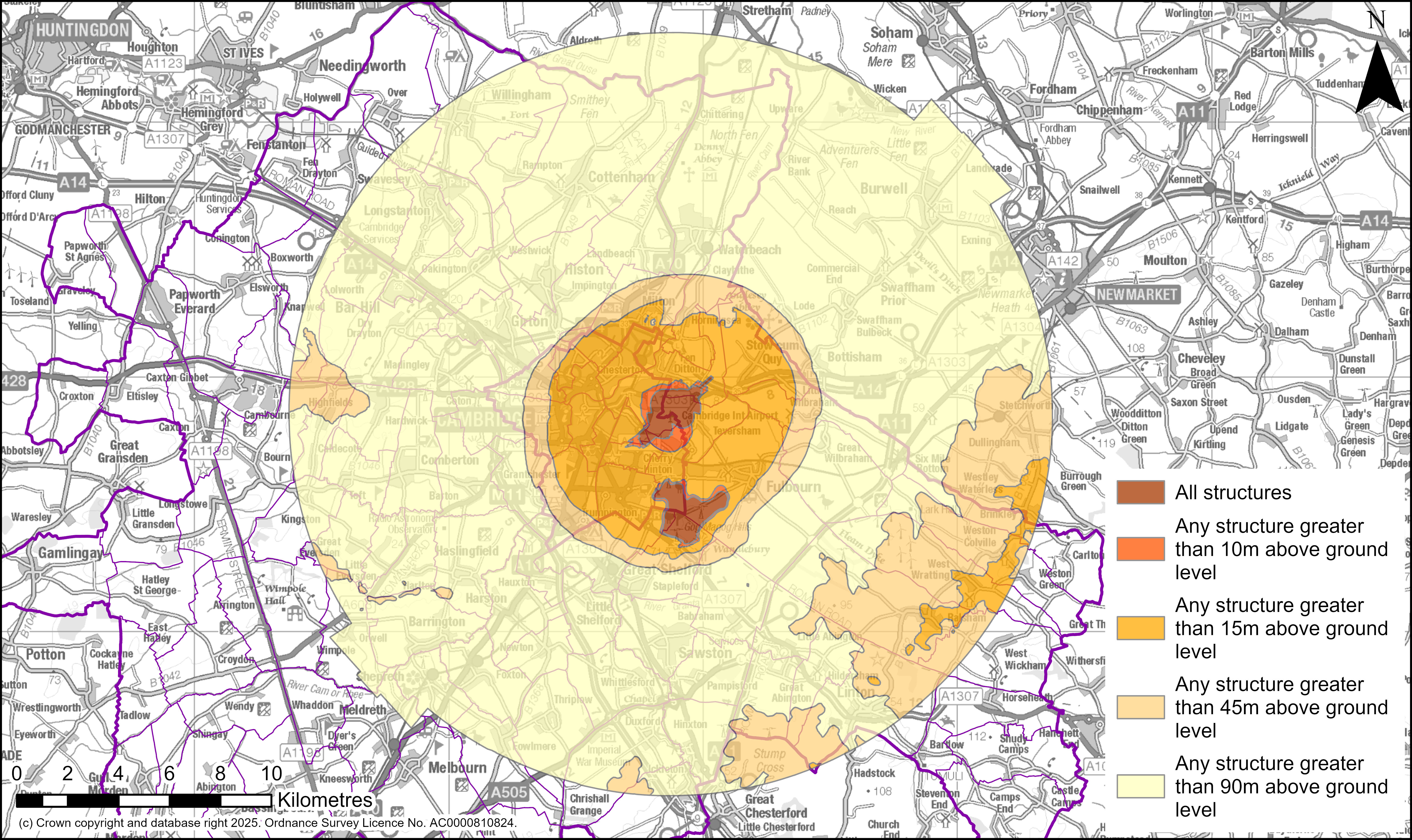
Although the Local Plan anticipates the Cambridge Airport site being redeveloped, whilst it remains operational planning decisions must take full account of safety requirements.
Public safety zones are identified where development is restricted whilst the airport is operational in order to minimise the number of people at risk of death or injury in the event of an aircraft crash on take-off or landing. The Airport Safeguarding zone is in place to ensure the safety of aircraft, their passengers and crew while taking off or landing or while flying in the vicinity of Cambridge Airport. This is achieved by assessing proposed development so as to:
- protect the air through which aircraft fly;
- protect the integrity of radar and other electronic aids to air navigation;
- protect visual aids, such as approach and runway lighting, by preventing them from being obscured, or preventing the installation of other lights; and
- avoid any increase in the risk to aircraft of a bird strike.
Applications for development within Cambridge Airport’s Air Safeguarding Zone (shown in Figure X) will be the subject of consultation with the operator of the airport and the Ministry of Defence. Restrictions in height, or changes to the detailed design of development may be necessary to mitigate the risk of aircraft accident and maintain the operational integrity of the airport.
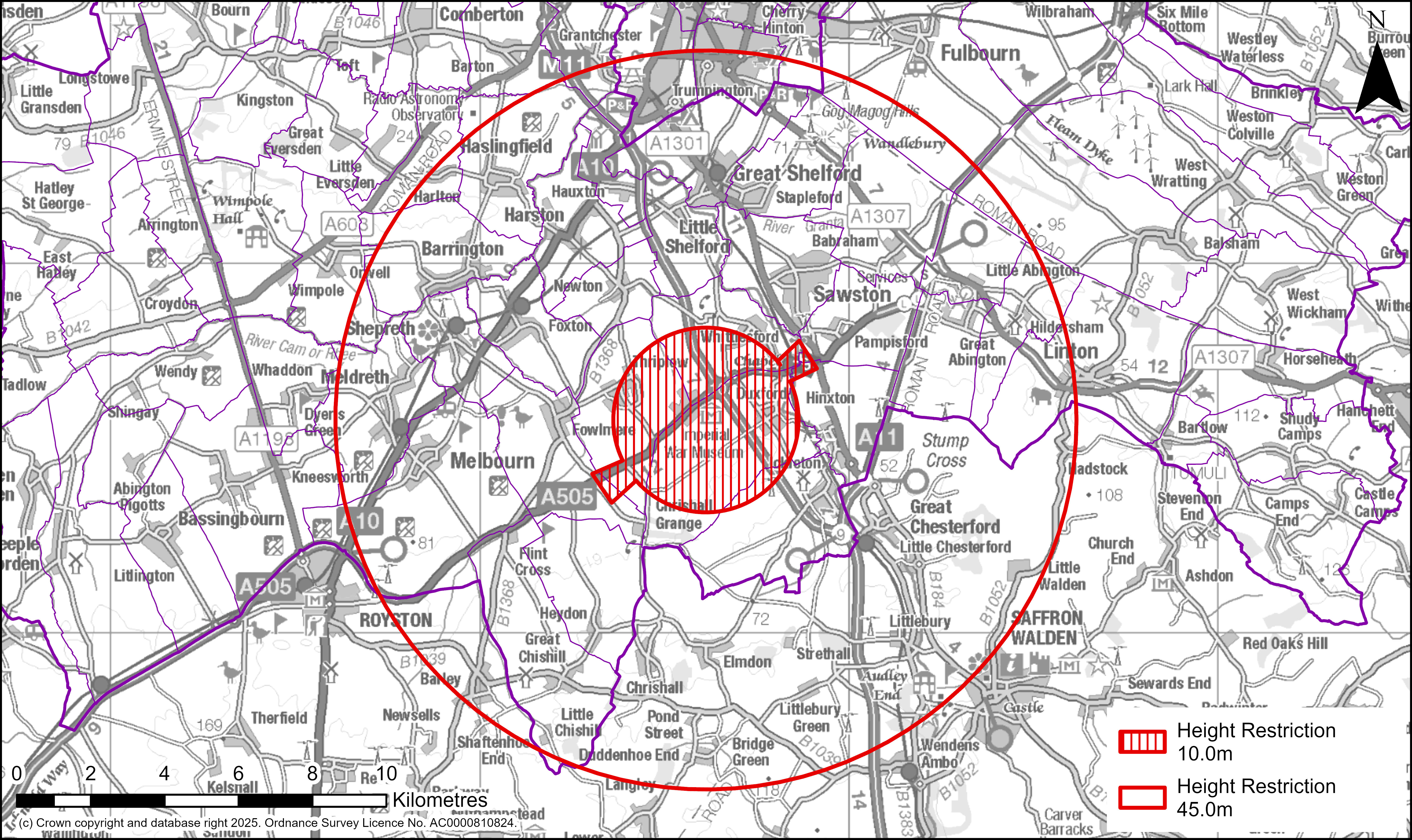
A similar Aerodrome Safeguarding Zone applies to the Imperial War Museum Duxford (Shown in Figure 00). Applications for development within Duxford’s Air Safeguarding Zones will be the subject of consultation with the aerodrome operator.
The internationally important Mullard Radio Astronomy Observatory at Lord’s Bridge contains unique radio and optical telescopes which are highly susceptible to many forms of interference, specifically electrical interference, light pollution and mechanical vibration. Arrangements are made to consult the University of Cambridge about the technical consequences for the observatory of proposed development. Harm caused to the Observatory will be overcome with use of conditions or planning obligations to regulate the installation and use of equipment likely to interfere with the operation of the observatory.
Bassingbourn Barracks and Barton Road Rifle Range have been identified as sites that play a role in supporting national defence activities. National planning policy sets out that planning policies should recognise and support development required for operational defence and security purposes. As per national planning policy, these operational defence sites will be protected from adverse impacts that may arise from other developments.
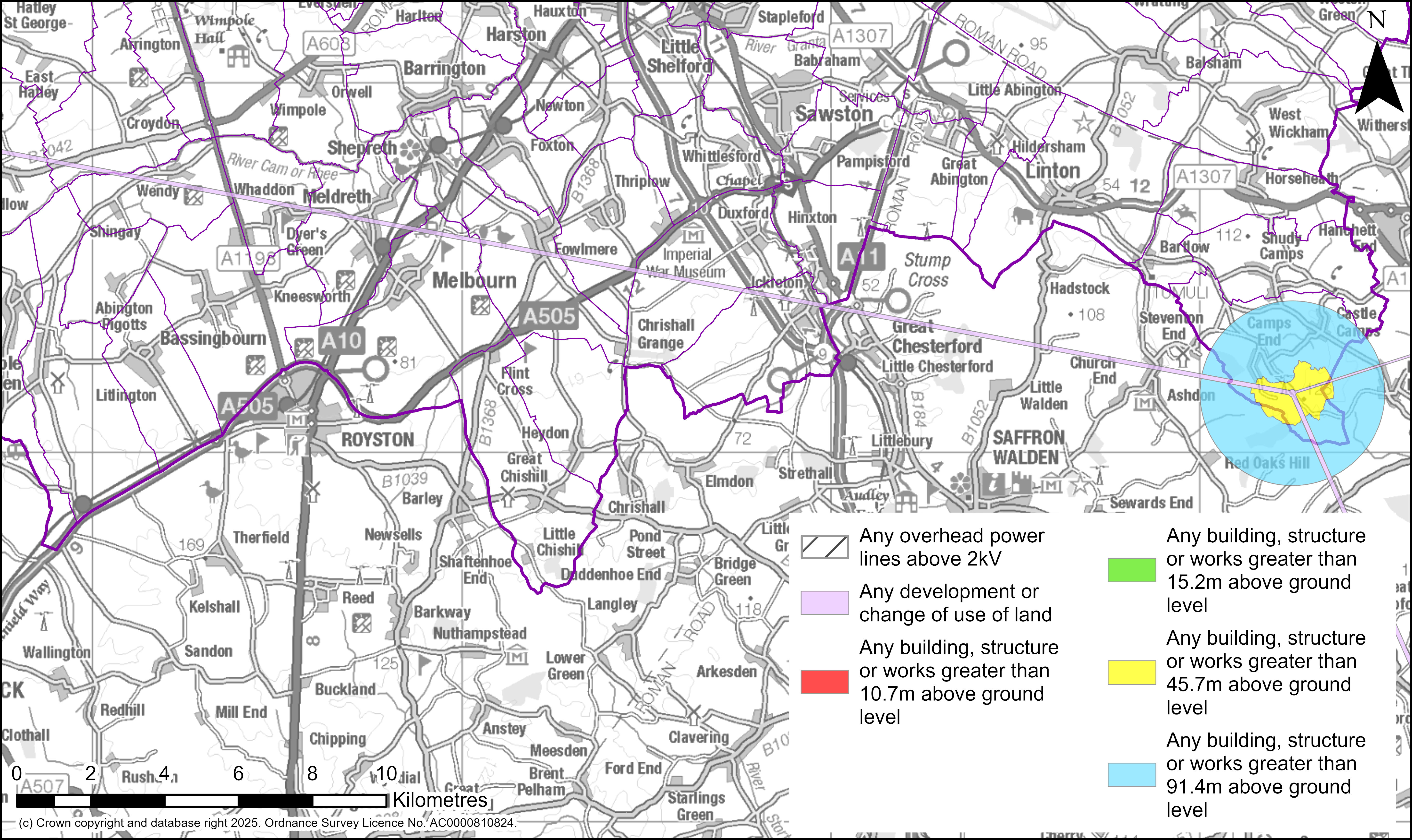
The East 2 WAM Network contributes to aviation safety by feeding into the air traffic management system in the Eastern areas of England. There is the potential for development to impact on the operation and/or capability of this technical asset which consists of nodes and connecting pathways. Development proposals within East 2 WAM Network safeguarding areas (shown in Figure 00), will be the subject of consultation with the MOD where development triggers the consultation requirement of the safeguarding area. Harm caused to the East 2 WAM Network will be overcome with use of conditions or planning obligations.
Supporting topic paper and evidence studies
- Greater Cambridge Local Plan: Topic Paper 8: Infrastructure (2025)
Tell us what you think
We will consider all comments while developing the next version of the Local Plan.
All comments must be received by 30 January 2026 at 5pm.