What will this policy do?
Allocate sites for homes or employment that support the overall development strategy within the rural area, excluding the rural southern cluster.
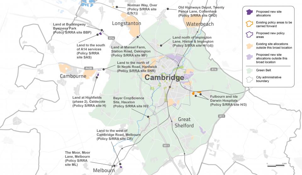
Proposed policy direction
The following allocations are proposed in or adjoining villages:
Housing
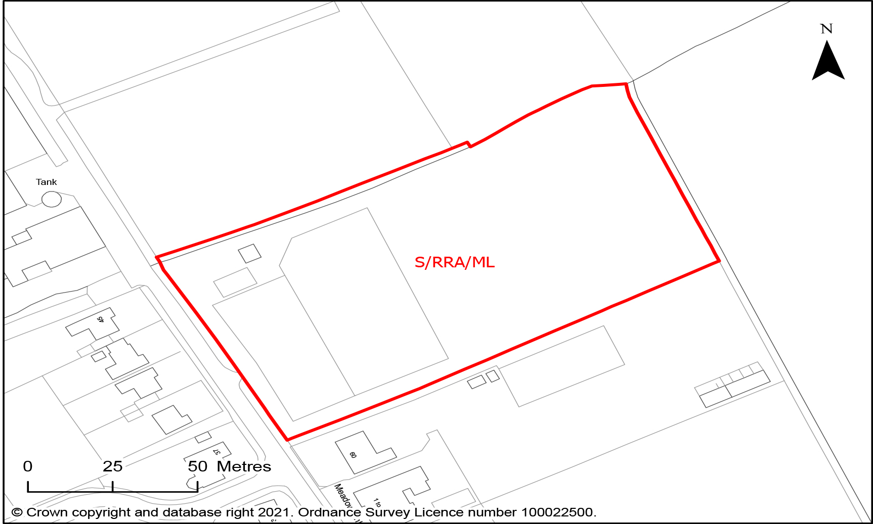
S/RRA/ML The Moor, Moor Lane, Melbourn
- Site area of 1 hectare
- Capacity for approximately 20 homes
- Development should accommodate the following constraints:
-
- Retain existing trees and strengthen the existing landscape buffer at the rear of the site
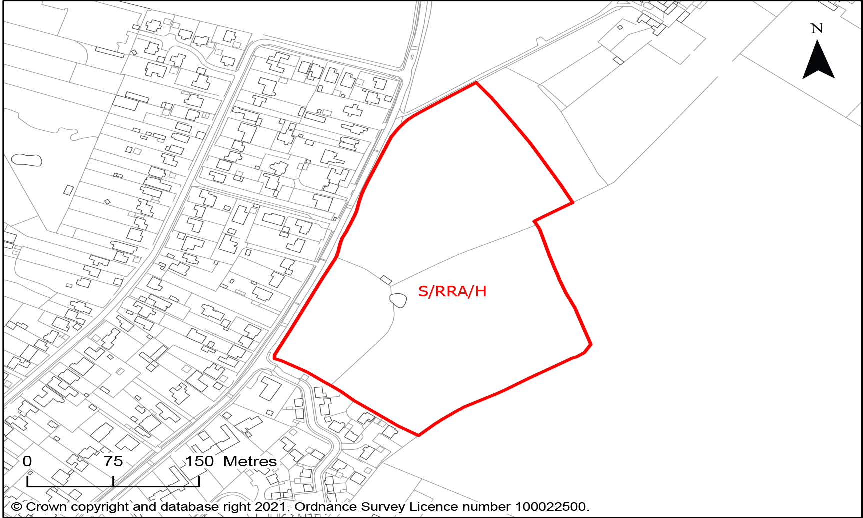
S/RRA/H Land at Highfields (phase 2), Caldecote
- Site area of 6 hectares
- Capacity for approximately 64 homes
- Site with lapsed planning permission in close proximity to Cambourne to Cambridge Public Transport Scheme stop
- Development should accommodate the following constraints:
-
- Provide substantial landscape buffer on eastern boundary.
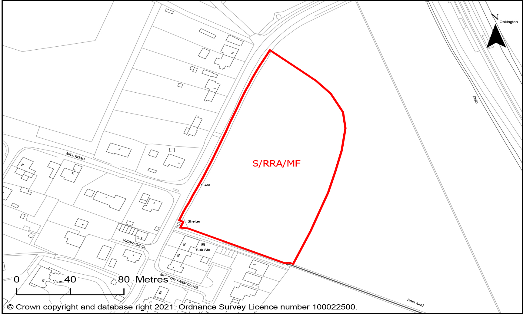
S/RRA/MF Land at Mansel Farm, Station Road, Oakington
- Site area of 1.4 hectares
- Capacity for approximately 20 homes
- Site in very close proximity to Cambridgeshire Guided Busway stop, providing excellent public transport access to Northstowe and Cambridge and enhancing the approach to the stop for pedestrians, providing the exceptional circumstances required for Green Belt release.
- Development should accommodate the following constraints:
-
- Provide pedestrian access towards the busway stop
- Provide substantial landscape buffer on eastern boundary.
Mixed use
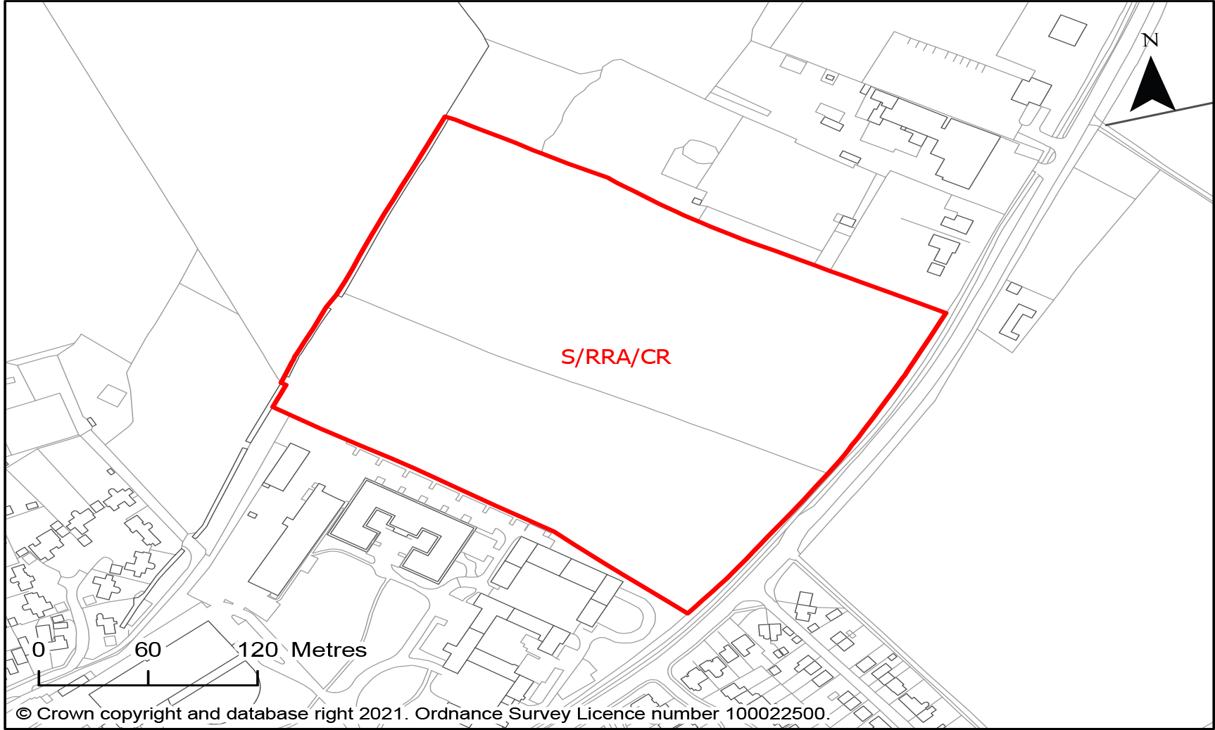
S/RRA/CR Land to the west of Cambridge Road, Melbourn
- Site area of 6.5 hectares
- Suggested for mixed use, with an indicative capacity for approximately 120 homes and 2.5ha for employment uses
- Opportunity to expand Melbourn Science Park and provide homes in a Minor Rural Centre
- Development should accommodate the following constraints:
-
- Note that deliverability for employment has yet to be confirmed
- Ensure integration of any employment uses within the existing Science Park
Employment
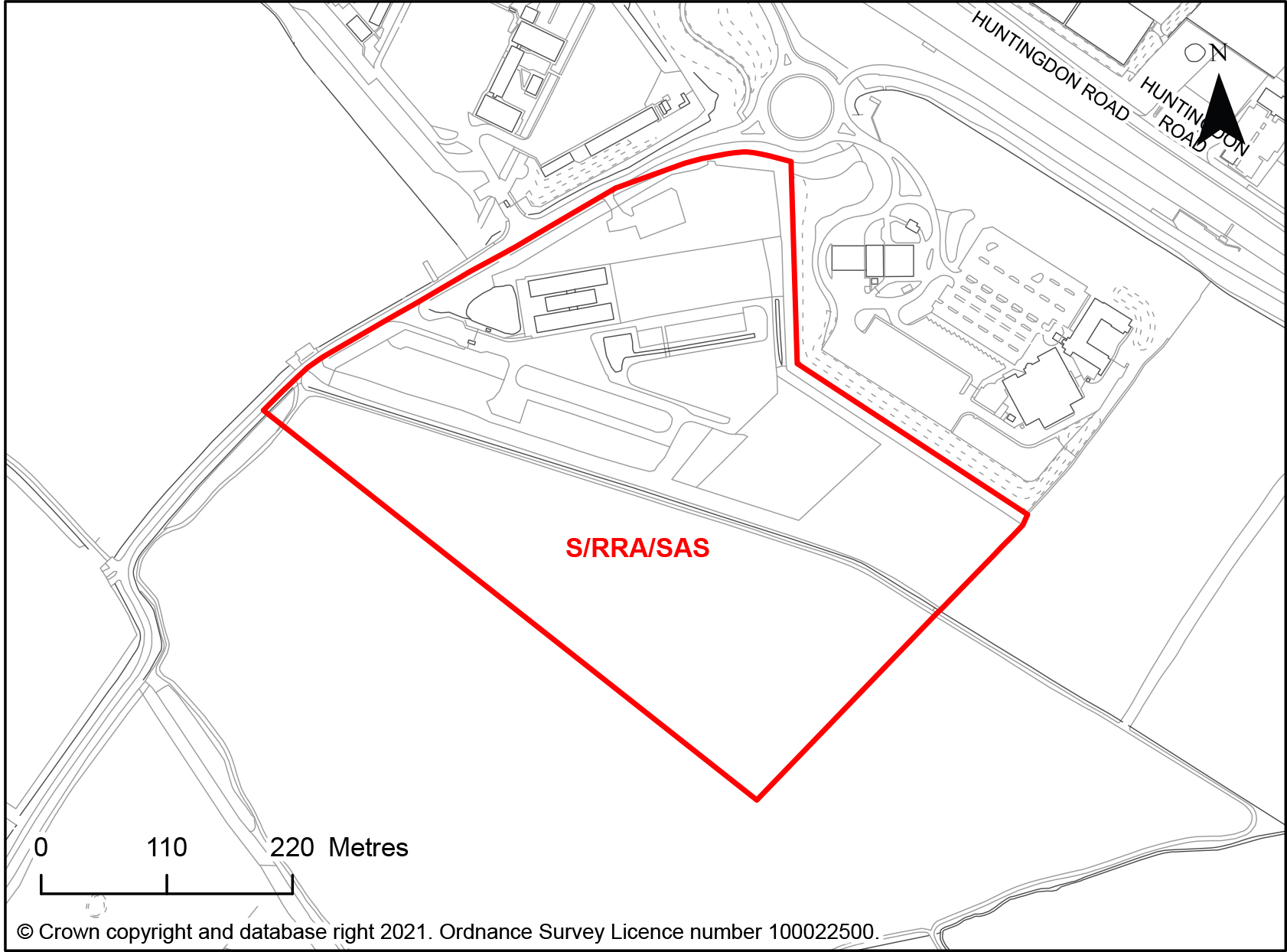
S/RRA/SAS Land to the south of the A14 Services
- Site area of 18.2 hectares.
- Suitable for the following uses: Class B2 (General Industrial) or Class B8 (Storage or Distribution) providing a range of small and medium sized units.
- Warehousing and distribution should focus on meeting sub regional needs, therefore the site should provide a mix of small to medium sized units.
- Site meeting evidenced outstanding demand for warehousing and distribution units located close to the strategic road network.
- Development should accommodate the following constraints:
-
- Site boundaries to provide landscape buffers of a minimum of 25m wide of native tree and understorey planting. Existing balancing ponds in the area to be re-profiled and used for drainage and biodiversity enhancement. Adequate space to be reserved within the site for large species tree planting and an amount of native understorey planting focused around the ponds. Existing watercourses to be utilised and enhanced with further native planting within the drainage proposals.
- The density of development to reflect the density and pattern of non-residential development in the nearby village of Boxworth.
- The preservation of the rural countryside character with the development integrated with local patterns of tree planting and hedgerows, hedges to be retained
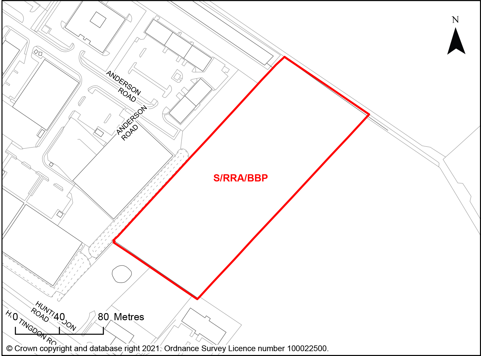
S/RRA/BBP Land at Buckingway Business Park, Swavesey
- Site area of 2.1 hectares
- Suitable for the following employment uses: Class B2 (General Industrial) or Class B8 (Storage or Distribution). B8 use would be limited to small to medium sized premises.
- Site meeting evidenced demand for warehousing and distribution units around Cambridge connected to the strategic road network, as an extension to an existing employment location.
- Development should accommodate the following constraints:
-
- Development at this site is contingent upon completing a detailed odour assessment related to the nearby Uttons Drove Water Recycling Centre, to understand the odour amenity constraints.
- A suitable safe access to be confirmed
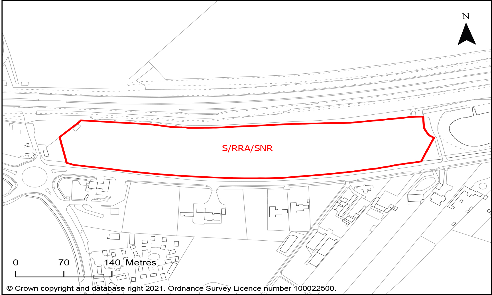
S/RRA/SNR Land to the north of St Neots Road, Dry Drayton
- Site area of 4.6 hectares
- Suitable for the following employment uses: E(g)(i) Offices to carry out any operational or administrative functions; E(g)(ii) Research and development of products or processes; and E(g)(iii) Industrial processes.
- Site meeting demand for local employment opportunities at Bourn Airfield New Village
- Development should accommodate the following constraints:
- Development form would need to account for the Cambourne to Cambridge transport scheme if it is routed through this area.
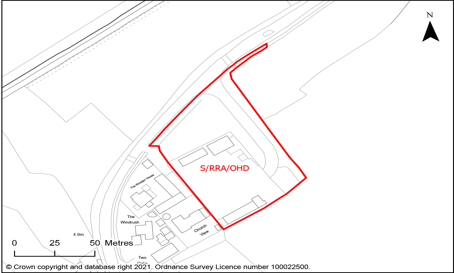
S/RRA/OHD Old Highways Depot, Twenty Pence Lane, Cottenham
- Site area of 0.6 hectares
- Suitable for employment Class E(g)(i) (offices to carry out any operational or administrative functions), E(g)(ii) (Research and development of products or processes), and E(g) and B8 (storage or distribution) development replacing the existing accommodation.
- Site meeting demand for industrial floorspace needs, on existing employment site of mostly brownfield land within the village framework of Cottenham, a Rural Centre with a substantial number of village services.
- Development should accommodate the following constraints:
-
- Built development to only include existing brownfield site
- The small portion of the site frontage that lies within Flood Zone 3.
- Enhancement of the Southern and eastern landscape boundaries and landscape and ecology within the site itself.
- Impacts on the wider settings of the nearby Grade 1 listed church and Conservation Area
Continuing existing allocations
The following allocations which are included within the South Cambridgeshire Local Plan 2018 are proposed to be carried forward into the new Greater Cambridge Local Plan.
Housing
- S/RRA/H/1 (d): Land north of Impington Lane, Histon & Impington (pdf)
Employment
- S/RRA/E/5(1): Norman Way, Over (1.7 ha.) (pdf)
- S/RRA/H/2: Bayer CropScience Site, Hauxton – with an amended boundary to include only the area for employment (class E (g)) uses, as all the new homes on this site have been completed. (pdf)
Mixed use
- S/RRA/H/3: Fulbourn and Ida Darwin Hospitals (pdf)
Allocation not proposed to be carried forward
The following allocations are not proposed to be carried forward for the reasons set out below:
Housing
- H1/e: Land off New Road and rear of Victoria Way, Melbourn – the development is either completed or under construction.
- H1/f: Green End Industrial Estate, Gamlingay – the development is under construction.
- H1/g: Land east of Rockmill End, Willingham – the development is under construction.
- H1/h: Land at Bennell Farm, Comberton (In Toft Parish) – the development is under construction.
Employment
- E/4:1: Longstanton: North of Hattons Road up to the bypass – this site was first identified in the 1993 Local Plan, as part of the Home Farm development. It has not come forward for employment uses, and does not warrant continued allocation given the alternative sites available. However, part of the site is being proposed as a new policy area for residential development and open space (see S/RRP/L).
- E/5:2: Papworth Everard: Ermine Street South – the development has been completed.
Why is this policy needed?
Housing in the rest of the rural area outside the southern cluster can help support delivery of a range of smaller sites within the area, and support the vitality of our villages.
To help support this aim, we looked for new sites within the rest of the rural area in all Rural Centres, Minor Rural Centres, or Group villages where they have a mainline railway station, are on Cambridgeshire Busway or on the route of planned public transport improvements, and considered the findings of the Housing and Employment Land Availability Assessment, including the environmental impacts of possible sites. Some of these villages are located within Green Belt. The Councils consider that the carbon benefits of locating homes close to existing opportunities for very high quality sustainable travel, could provide the exceptional circumstances required to justify removing land from the Green Belt in this location but only if considered alongside the environmental impacts.
For employment, we considered the evidence from our Greater Cambridge Employment Land Review & Economic Development Evidence Base (2020) to understand the locational demand of different sectors. We then reviewed site opportunities to identify the preferred list of sites. The site selection was informed by the Housing & Employment Land Availability Assessment, and taking into account sustainable travel opportunities alongside the likely travel requirements of the proposed uses. We identified land that could respond to the need for local warehousing and distribution with good access to the highway network. We also identified some small-scale opportunities in accessible locations which could add the mix and types of land available.
The adopted South Cambridgeshire Local Plan includes a number of land allocations at villages. Most of these have been developed, gained planning permission or are being progressed, and therefore it is no longer necessary to include a policy framework for their development in the Local Plan. A few are still to be brought forward or are still going through the planning process, and therefore a policy framework needs to be retained for these sites. However, this will be kept under review as the plan progresses.
What consultation have we done on this issue?
There was no specific consultation on this issue in the First Conversation consultation.
What alternatives did we consider?
We considered a range of alternative sites within the rest of the rural area having regard to the overarching development strategy and the conclusions of the Housing and Employment Land Availability Assessment. We discounted sites considered to be less suitable for development.
Supporting evidence studies and topic papers
- Greater Cambridge Local Plan: Topic paper 1: Strategy
- Greater Cambridge Employment Land Review & Economic Development Evidence Base (2020)
- Housing & Employment Land Availability Assessment (2021)
Existing policies in adopted 2018 Local Plans
South Cambridgeshire Local Plan 2018
- Policy H/1: Allocations for Residential Development at Villages
- Policy H/2: Bayer CropScience Site, Hauxton
- Policy H/3: Fulbourn and Ida Darwin Hospitals
- Policy E/4: Allocations for Class B1 Employment Uses
- Policy E/5: Allocations for Class B1, B2 and B8 Employment Uses
Tell us what you think
Our consultation for this phase is now closed.